Uderns
|
Uderns
|
||
|---|---|---|
| coat of arms | Austria map | |
|
|
||
| Basic data | ||
| Country: | Austria | |
| State : | Tyrol | |
| Political District : | black | |
| License plate : | SZ | |
| Surface: | 6.72 km² | |
| Coordinates : | 47 ° 20 ' N , 11 ° 52' E | |
| Height : | 549 m above sea level A. | |
| Residents : | 1,853 (January 1, 2020) | |
| Population density : | 276 inhabitants per km² | |
| Postal code : | 6271 | |
| Area code : | 05288 | |
| Community code : | 7 09 35 | |
| NUTS region | AT335 | |
| UN / LOCODE | AT UDE | |
| Address of the municipal administration: |
Dorfstrasse 23 6271 Uderns |
|
| Website: | ||
| politics | ||
| Mayor : | Josef Bucher | |
|
Municipal Council : (2016) (13 members) |
||
| Location of Uderns in the Schwaz district | ||
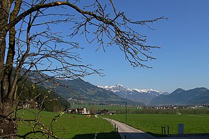
 View of Uderns from the south |
||
| Source: Municipal data from Statistics Austria | ||
Uderns is a municipality in the Zillertal with 1853 inhabitants (as of January 1, 2020) and belongs to the Schwaz district in Tyrol ( Austria ). The community is located in the judicial district of Zell am Ziller .
geography
Uderns lies between Fügen and Ried in the lower Zillertal on the rubble cone of the Finsingbach . In addition to the street village of Uderns, the village of Finsing and the Rotte Kleinboden on the border with Fügen as well as the farm settlement Kupfnerberg on the hillside belong to the municipality.
Community structure
The municipality includes the following three localities (residents as of January 1, 2020):
- Finsing (926)
- Kleinboden (105)
- Uderns (822)
Neighboring communities
Fügen , Fügenberg , Hart im Zillertal , Ried im Zillertal , Stumm .
history
The meaning of the pre-Roman place name is unclear. However, settlement of the area around Uderns is certain as early as the Bronze Age . Between 500 and 600 Bavarians immigrated from the Inn valley and mingled with the local Rhaeto-Romanic population.
Finsing was first documented in 927 as “Funzina” and Uderns in 933 as “Udarnes” , each in ownership transfers to the Archbishopric of Salzburg . In contrast to most of the other communities in the valley, Uderns has always been part of Tyrol. In 1483 Uderns appears for the first time as an independent municipality.
From the 16th to the 19th century, iron ore mining in Finsinggrund and the blast furnaces and iron hammer mill in Kleinboden played a major role in the economic life of Uderns. The Finsingbach supplied energy for several commercial enterprises, the charcoal for the blast furnaces came mainly from the "Kohlstatt" in the municipality of Hart in the Zillertal on the opposite side of the valley. The wood was obtained from the surrounding area and the entire rear of the Zillertal. Until after the First World War, wood was lifted from the Finsinggrund. The closure of the iron hammer mill in Kleinboden in 1870 meant a major economic setback for Uderns.
There was also a well-known oil distillery in the village.
coat of arms
Blazon : In red a slanting left, fallen, red-nailed, silver horseshoe.
The horseshoe symbolizes the blacksmith's trade, which used to be the most important industry along the Finsingbach. The red background shows that Uderns is one of the few communities in the Zillertal that has always belonged to Tyrol.
Culture and sights
economy
In addition to agriculture and tourism, industry and trade are relatively well represented in the municipality. A care facility for disabled children and young people is important. There is also an 18-hole golf course with driving range in town.
traffic
Uderns is located on the Zillertalstrasse and the Zillertalbahn . Since 2006 Uderns has had a new driveway in the middle of the village.
The Zillertal train station in Uderns has been permanently occupied again since 2003. Here people who are accompanied by Lebenshilfe are deployed as workers. This project was submitted for the SozialMarie 2009 in a competition about integration.
Personalities
- Heinz Kinigadner (* 1960), motocross driver
- Friedrich Hell (1892–1957), artist
- Leonhard Posch (1750–1831), sculptor
Web links
- 70935 - Uderns. Community data, Statistics Austria .
Individual evidence
- ↑ Statistics Austria: Population on January 1st, 2020 by locality (area status on January 1st, 2020) , ( CSV )
- ↑ Martin Bitschnau , Hannes Obermair : Tiroler Urkundenbuch, II. Department: The documents on the history of the Inn, Eisack and Pustertal valleys. Vol. 1: Up to the year 1140 . Universitätsverlag Wagner, Innsbruck 2009, ISBN 978-3-7030-0469-8 , p. 103 ff., No. 137 and 141 .
- ↑ Uderns train station (Tyrol) accessed on October 18, 2009


