Schwendau
|
Schwendau
|
||
|---|---|---|
| coat of arms | Austria map | |
|
|
||
| Basic data | ||
| Country: | Austria | |
| State : | Tyrol | |
| Political District : | black | |
| License plate : | SZ | |
| Surface: | 17.35 km² | |
| Coordinates : | 47 ° 12 ' N , 11 ° 52' E | |
| Height : | 620 m above sea level A. | |
| Residents : | 1,760 (January 1, 2020) | |
| Postcodes : | 6283, 6290, 6292 | |
| Area code : | 05285/05282 | |
| Community code : | 7 09 27 | |
| NUTS region | AT335 | |
| Address of the municipal administration: |
Johann-Sponring-Strasse 80 6283 Schwendau |
|
| Website: | ||
| politics | ||
| Mayor : | Franz Hauser | |
|
Municipal Council : (2016) (13 members) |
||
| Location of Schwendau in the Schwaz district | ||
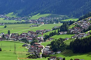
 Schwendau and Hippach-Dorf from the north |
||
| Source: Municipal data from Statistics Austria | ||
Schwendau is a municipality with 1760 inhabitants (as of January 1, 2020) in the Zillertal and belongs to the Schwaz district in Tyrol ( Austria ). The community is located in the judicial district of Zell am Ziller .
geography
Schwendau is located in the rear of the Zillertal, west of the Ziller . Astegg, Burgschrofen, Burgstall, Hippach, Hoarberg, Kleinschwendberg, Kreuzlau, Mühlbach, Mühlen, Penken, Schwendau and Stockach belong to the municipality, which spreads out on the alluvial cones of several streams. The community stretches from the Ziller to the 2590 m high Hoarbergjoch. The main town of Schwendau did not develop until after the Second World War .
Schwendau uses many facilities together with the neighboring municipality of Hippach , so the two municipal offices are housed in the same building in Schwendau (only 30 m from the shared municipality border).
Neighboring communities
| Hippach | Ramsau in the Zillertal | |
| Tux |

|
|
| Finkenberg | Mayrhofen |
history
Schwendau was first around the year 1200 as Swentowe (clearing in a Au) in a land register of the Archbishopric Salzburg mentioned. A castle allegedly sat enthroned on the Burgstallschrofen hill until the 14th century (not yet confirmed after archaeological excavations in 2015). Schwendau has been a political municipality since 1817.
In a referendum in 2003, the population spoke out against the merger with Hippach.
Culture and sights
economy
In addition to commercial operations and agriculture, tourism with the Ski Zillertal 3000 ski area is economically important . A larger proportion of the employees are out-commuters.
TIWAG's Sidan power plant is located on the Sidanbach . It was put into operation in the summer of 1994 and has an engine output of 4.4 MW.
traffic
Schwendau can be reached via the Zillertalstraße and the Ramsau-Hippach train station with the Zillertalbahn .
Web links
- 70927 - Schwendau. Community data, Statistics Austria .
- History-Tyrol: Schwendau


