
Weer
|
Weer
|
||
|---|---|---|
| coat of arms | Austria map | |
 |
|
|
| Basic data | ||
| Country: | Austria | |
| State : | Tyrol | |
| Political District : | black | |
| License plate : | SZ | |
| Surface: | 5.6 km² | |
| Coordinates : | 47 ° 18 ' N , 11 ° 39' E | |
| Height : | 558 m above sea level A. | |
| Residents : | 1,610 (January 1, 2020) | |
| Postal code : | 6116 | |
| Area code : | 05224 | |
| Community code : | 7 09 37 | |
| NUTS region | AT335 | |
| UN / LOCODE | AT TWR | |
| Address of the municipal administration: |
Dorfstrasse 4 6116 Weer |
|
| Website: | ||
| politics | ||
| Mayor : | Markus Zijerveld | |
|
Municipal Council : (2016) (13 members) |
||
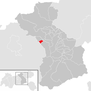
| Location of Weer in the Schwaz district | ||
  |
||
 Weer from the south |
||
| Source: Municipal data from Statistics Austria | ||

Weer is a municipality with 1610 inhabitants (as of January 1, 2020) in the Schwaz district in Tyrol ( Austria ). The community is located in the judicial district of Schwaz .
geography
The clustered village is located on the eastern part of the Murkegel des Weerbach at an altitude of 558 meters. The Weerbach (a small side stream of the Inn ) rises in the Tuxer Voralpen and forms the border between the districts of Schwaz and Innsbruck-Land as well as between the two communities Weer and Kolsass. South of the village in the Tux Alps lies the Geiseljoch , over which a road that is closed to public traffic leads into the Tuxertal .
Of the community area (561 hectares), around 330 hectares are used intensively for agriculture.
Neighboring communities
Neighboring communities are (alphabetically): Kolsass , Kolsassberg , Pill , Terfens and Weerberg .
history
There are numerous prehistoric finds in the area. Many old court and field names also indicate later Roman settlement. From Innsbruck, the Roman road led down the Inn Valley , including through Weer.
Around 550 the Bavarians invaded the Weer area from the Tyrolean Lower Inn Valley. The place name, probably derived from a Celto-Illyrian language root, was first mentioned in a document in 1075. Like the entire Schwazer Bergrevier, Weer experienced a heyday in the 16th century. A gold panning was operated in Weer around 1500, and a smelter was in operation for the iron extracted on the Kolsassberg . In the 16th century, the floodplains on the Inn began to be cleared, which doubled the number of farms.
Weer was a farming village until the Second World War . As a result of the industrialization in the Wattens and Schwaz area, there was a lot of building activity, and so numerous residential buildings were built in the districts of Gries and Weerer Ebene. Weer is therefore a popular community today, so there are more outbound than inbound commuters.
Culture and sights

Personalities
- Veit Graber (1844-1892), zoologist
Individual evidence
- ↑ homepage Gem. Weer , accessed on January 20, 2014
- ^ Agathe Gaisböck: Contribution to the settlement and economic history of the lower Inn Valley. History of the communities Weer and Weerberg , in: Tiroler Heimat 6, 1933, pp. 48–127.
Web links
- 70937 - Weer. Community data, Statistics Austria .
Achenkirch | Aschau im Zillertal | Brandberg | Bruck am Ziller | Book in Tyrol | At the Achensee | Finkenberg | Joining | Fügenberg | Gallzein | Gerlos | Gerlosberg | Hainzenberg | Hart in the Zillertal | Hippach | Jenbach | Kaltenbach | Mayrhofen | Pill | Ramsau im Zillertal | Ried im Zillertal | Rohrberg | Schlitters | Schwaz | Schwendau | Stans | Steinberg am Rofan | Strass im Zillertal | Mute | Stummerberg | Terfens | Tux | Uderns | Vomp | Weer | Weerberg | Wiesing | Zell am Ziller | Zellberg