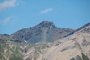
Lizumer Reckner
| Lizumer Reckner | ||
|---|---|---|
|
Lizumer Reckner from the south |
||
| height | 2886 m above sea level A. | |
| location | Tyrol , Austria | |
| Mountains | Tux Alps | |
| Dominance | 7.7 km → Kleiner Kaserer | |
| Notch height | 548 m ↓ Tuxer Joch | |
| Coordinates | 47 ° 8 '39 " N , 11 ° 37' 50" E | |
|
|
||
| rock | Serpentinite | |
|
Lizumer Reckner from the north |
||
The Lizumer Reckner is 2886 m above sea level. A. the highest mountain in the Tux Alps in Tyrol .
Location and surroundings
The Lizumer Reckner is located in the center of the Tux Alps, about 20 kilometers southeast of Innsbruck within the Lizum Walchen military training area . In its west lies the Navistal , in the southeast the Schmirntal , in the east the Wattentaler Lizum . The Tuxertal is not far in the southeast. The neighboring mountain in the south is the vulture . A mountain ridge continues to the north to the Lizumer Sonnenspitze , the Tarntaler Köpfe and further on to the Mölser Berg . To the west of the Lizumer Reckner is the 2824 m high Naviser Reckner .
geology
The Reckner lies on the edge of the Tauern Window , a region of the Eastern Alps in which the Penninic nappes and possibly also the Helvetic nappes are exposed. The summit structure of the Reckner consists of serpentinite , which is mainly embedded in radiolarite . Furthermore, dolomite breccias , limestone slate and other Jura rocks can be found in the geologically diverse environment .
Below the top of the Reckner there are block heaps that are interpreted as the remains of former rock glaciers . Remnants of dead ice can also be found here.
Bases and paths
From the Navistal, the mountain can be reached via the Naviser Hut ( 1767 m ) or the Peeralm ( 1663 m ), among others . In the Schmirntal, the hamlet of Obern serves as the starting point. The Reckner can be reached from the Tuxertal via the 1984 m high Junsbergalm or from Hintertux. The most important base in the Wattentaler Lizum is the Lizumer Hütte ( 2019 m ).
The southern foot of the summit structure can be reached from all these starting points via several marked hiking trails. In particular, the ascent from the Lizum is also possible as a ski tour in winter . The last ascent to the summit is quite minimalist with step / grip aids and requires grade II climbing .
Due to the location within the military training area, climbing the mountain may be temporarily prohibited.
Web links
Individual evidence
- ↑ a b c Austrian map 1: 50,000, AMAP Online. Federal Office for Metrology and Surveying ; Retrieved April 13, 2011
- ↑ FK Bauer: The geological structure of Austria . Ed .: Federal Geological Institute . Springer, 1980, ISBN 978-3-211-81556-4 , pp. 307 ( Google Books ).
- ↑ Christian Dingeldey: Report 1998 on geological recordings in the Quaternary of the Tarntaler Mountains on sheet 149 Lanersbach . Ed .: Federal Geological Institute . S. 305 ( geologie.ac.at [PDF; accessed on April 14, 2011]).
- ↑ Sepp Brandl, Gerhard Hirtlreiter: Kitzbühel Alps, Tux and Zillertal Alps: Brixental, Spertental, Windau, Kelchsau, Wildschönau, Alpbachtal, Zillertal, Tuxer Tal, Hochfügen, Weerberg, Wattentaler Lizum . 50 ski tours in the Tyrolean lowlands, between Inntal and Pass Thurn, Hochfügen and Gerlos. Bergverlag Rother, 2006, ISBN 978-3-7633-5910-3 , p. 95 ( Google Books ).
- ^ Wattenberg community , accessed on April 14, 2011


