
Little Kaserer
| Little Kaserer (Kaserer) | ||
|---|---|---|
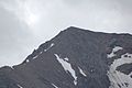
 View of the Kleiner Kaserer from the White Wall |
||
| height | 3093 m above sea level A. | |
| location | Tyrol , Austria | |
| Mountains | Zillertal Alps | |
| Dominance | 0.57 km → Großer Kaserer | |
| Notch height | 108 m ↓ Höllscharte | |
| Coordinates | 47 ° 4 '6 " N , 11 ° 38' 45" E | |
|
||
| rock | Granite , gneiss | |
| First ascent | 1850 on the occasion of the national survey | |
| Normal way | Tuxerjochhaus , north ridge to point 2905, Kaserergrat (northeast ridge) to the summit | |

The Kleine Kaserer is 3093 m above sea level. A. high mountain in the Zillertal Alps in the Austrian state of Tyrol .
It is part of the Kaserer mountain group, which is adjacent to the Olperer , consisting of the large , the wrong and the small Kaserer. Often the Kleine Kaserer is simply referred to as the Kaserer and the Großer Kaserer as the Haserer . There is a summit cross on the summit of the Kleiner Kaserer .
location
The pyramidal Kleine Kaserer borders the Hintertux Glacier (Gefrorne-Wand-Kees) in the west and at the same time forms the end of the Kaserer Winkel, a side valley of the Schmirntal .
Neighboring mountains in the east at the other end of the Hintertux Glacier are the Gefrorene-Wand-Spitzen , in the north the imposing Lärmstange and the Hornspitze and in the south the Große and Falsche Kaserer. In the west, the next elevations are the Schöberspitzen .
Bases and routes
Due to the very low dominance , the hiker is denied a special distant view. The excellent view of the Hintertux Glacier and the Zillertal , Tux and Stubai Alps as well as the relatively easy ascent for a three-thousand-meter peak - according to literature using easy climbing ( difficulty level UIAA I ) - make it a very popular hiking destination.
Easiest routes are:
- From the Tuxerjochhaus at 2313 m above sea level. A. ) you can reach the Kaserer Schartl ( 2,448 m above sea level ) via the Frauenwand ( 2541 m above sea level ). From there of trails lead initially from the north rather gently upward and later reached a little steeper on the survey point 2905 (m oa) from which one on the Kaserergrat (North Ridge) in a light block climbing the peak, difficulty UIAA I .
- An ascent from the west via Höllscharte or Kleegrubenscharte is also easy to climb.
Detailed view of the Kaserer ridge with a clearly recognizable summit cross

The Kaserer Winkel with the Little Kaserer


Literature and map
- Heinrich Klier and Walter Klier : Alpenvereinsführer Zillertal Alps , Munich 1996, ISBN 3-7633-1269-2 , p. OA
- Alpine Club Map 1: 25,000, sheet 35/1.