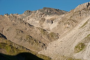
Vulture (Tux Alps)
| vulture | ||
|---|---|---|
|
The vulture from the northeast |
||
| height | 2857 m above sea level A. | |
| location | Tyrol , Austria | |
| Mountains | Tux Alps | |
| Dominance | 0.41 km → Lizumer Reckner | |
| Notch height | 51 m ↓ Scharte to Reckner | |
| Coordinates | 47 ° 8 '24 " N , 11 ° 37' 58" E | |
|
|
||
| rock | Serpentinite , predominantly lherzolite | |
The vulture is the second highest point in the Tux Alps .
The vulture is located in the center of the Tux Alps, where the Schmirntal valley to the southwest, the Navistal valley to the west, the Tux valley to the east , and the Wattental valley to the north come together. The much more rugged Lizumer Reckner , the highest mountain in the Tux Alps, is 450 meters north of the Geier . About 400 meters south-east of the Geier summit, at about 2660 m, lies the Junssee, which is about 200 by 100 meters . With the exception of the southwest flank, the vulture belongs to the Lizum-Walchen military training area . Like the Lizumer Reckner, the Geier can also be climbed from all four adjacent valleys. The Geier is often climbed as a ski tour from the Lizumer Hütte in Wattental, even in winter . At the summit of the Geier there is a sheet metal vulture based on the name of the mountain.
geology
The summit area is mainly formed from serpentinites of the Reckner complex , predominantly lherzolites, subordinate also Harzburgite and Dunite . The Reckner complex is a former oceanic crust , so-called ophiolite . The Reckner complex is located in the border area between the Lower Eastern Alps in the north and the Tauern Window in the south and is assigned to either the Penninic or the Lower Eastern Alps.
Web links
Individual evidence
- ↑ Lizumer Hütte, Skitour auf den Geier ( Memento of the original from December 3, 2013 in the Internet Archive ) Info: The archive link has been inserted automatically and has not yet been checked. Please check the original and archive link according to the instructions and then remove this notice.
- ↑ Friedrich Koller: 5th Workshop of Alpine Geological Studies, Field Tripe Guide E5, Low-T - High-P Metamorphism in the Tarntal Mountains, (Lower Austroalpine Unit) (PDF; 424 kB)
- ↑ Provisional geological map of the Republic of Austria , Geofast 1: 50,000, sheet 149, Lanersbach


