
Brooders
| Brooders | ||
|---|---|---|
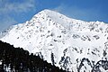
 The Malgrübler vom Glungezer , on the right the Sunntiger |
||
| height | 2749 m above sea level A. | |
| location | Tyrol , Austria | |
| Mountains | Tux Alps | |
| Dominance | 4.1 km → Rosenjoch | |
| Notch height | 270 m ↓ Naviser Jöchl | |
| Coordinates | 47 ° 12 '2 " N , 11 ° 35' 18" E | |
|
||
| rock | Metamorphic rocks of the Innsbruck quartz phyllite complex | |
| Age of the rock | Ordovician to Devon | |
| Normal way | From the Voldertal over the west ridge | |

The Malgrübler is a 2749 m above sea level. A. high mountain in the Tux Alps in the Austrian state of Tyrol . It is the highest point in the ridge between the Voldertal in the west and the Wattental in the east. The east and south-east sides of the mountain are in the area of the Lizum-Walchen military training area .
topography
The Malgrübler has an expansive mountain shape that only drops off steeply in a south-easterly direction. The Malgrübler contrasts with its southern neighbor, the Sunntiger ( 2667 m ), a steep rock head. On its west side, the Malgrübler sends a broad ridge towards the Voldertal . In the area around this ridge, the slopes of the Malgrübleralm lie above the tree line .
Climbs
The Malgrübler can be easily reached from the Vorbergalm in the Voldertal. The ascent leads over the west ridge to the summit. In winter you can also climb the Malgrübler on skis from the Vorbergalm. The usual ascent route roughly follows the west ridge. At the end you climb through a hollow south of this ridge and over a short flank to the summit. But you can also cross from the ascent to the Haneburger to the Malgrübler. Above all, this ascent variant is only recommended in good snow conditions because of the partially blocky ground.
Web links
swell
- ^ Rudolf Weiss: Skitouren Zillertaler Alpen, Tuxer Alpen , Steiger Verlag Berwang 1988, ISBN 3-85423-054-0 , p. 65
The painter brooder from the east

On the Malgrübler with a view to the northwest

From the northwest


