Lungauer Kalkspitze
| Lungauer Kalkspitze | ||
|---|---|---|
|
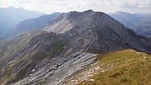
View from the valley floor in the west to the Lungauer Kalkspitze |
||
| height | 2471 m above sea level A. | |
| location | Salzburg , Austria | |
| Mountains | Schladminger Tauern , Lower Tauern | |
| Dominance | 2.7 km → Engelkarspitze | |
| Notch height | 412 m ↓ Znachsattel | |
| Coordinates | 47 ° 16 '20 " N , 13 ° 37' 30" E | |
|
|
||
| rock | weakly metamorphic dolomite and limestone | |
| Age of the rock | Triad | |
The Lungauer Kalkspitze is 2471 m above sea level. A. high peak in the Schladminger Tauern in Austria . It is located in Salzburg's Lungau and is a popular tour destination in both summer and winter.
location
The Lungauer Kalkspitze is located in the western part of the Schladminger Tauern , opposite the somewhat lower Styrian Kalkspitze ( 2459 m ), on which the border between Salzburg and Styria is located. The two peaks form the southern end of the valley of the Styrian Preuneggtal and are separated by the Akarscharte ( 2315 m ). The summit offers an excellent panoramic view of the surrounding mountains: from the Hohe Tauern and Hochkönig in the west to the Dachstein in the north and the Hochgolling in the east to the Nockberge in the south.
geology
A special feature of the mountain is the type of rock from which the mountain stock (including the Styrian Kalkspitze ) is largely built and from which it owes its name. For the most part, this is carbonate rock , while most of the other mountain ranges in the Schladminger Tauern consist of crystalline slate and gneiss , which is typical of the Central Alps . This means that the two limestone peaks are geologically more similar to the neighboring mountains of the Radstädter Tauern than their eastern neighbors in the Schladminger Tauern.
Specifically, it is an inverse sequence (d. E., The age of the rock increases from the footwall to the hanging wall to) from the Middle Triassic and possibly Upper Triassic massive and banked dolomite and Kalkmarmoren. The interfaces of these units dip preferentially to the east. Mainly on the western flank pending Dolomite recent Middle Triassic ( Ladin ) may be an equivalent of the Wetterstein dolomite of the Northern Limestone Alps . On the other hand, on the actual mountain peak, there are Central or Lower Triassic quartzite ("Lantschfeld quartzite"). In addition, in contrast to the Styrian Kalkspitze, there are also paragneiss on the east side of the summit . The entire sequence (excluding the paragneiss) was previously tectonostratigraphically attributed to the weakly metamorphic (green slate facies) Central Alpine Permomesozoic of the Radstadt Alps of the Lower Eastern Alps. The paragneiss of the summit area, on the other hand, has always been attributed to the Schladming crystalline complex of the polymetamorphic basement of the Middle Eastern Alps. Today, however, the entire mountain is interpreted as the overturned (inverse) Central Eastern Alpine (crystalline underlain by the reverse Mesozoic) of the Lower Tauern (formerly called Middle Eastern Alpine).
Ascents
Two of the most popular long-distance hiking trails in Austria, the Zentralalpenweg 02 and the Arnoweg, lead through the Akarscharte , which is why both Kalkspitzen are often climbed. In the summit area, the path to the Lungauer Kalkspitze requires surefootedness.
bases
- Oberhütte (private, 1859 m )
- Giglachseehütte (private, 1955 m )
- Ignaz-Mattis-Hütte , ( ÖAV section Vienna, 1986 m )
Walking times
- from the Ursprungalm ( 1604 m ) via the Znachsattel: 2½ hours
- from Obertauern ( 1739 m ) on long-distance hiking trail 02: approx. 5 hours
- from Hopfriesen ( 1040 m ) over the Giglach Lakes: 5 hours (2 hours from the Ignaz Mattis Hut)
swell
- ↑ G. W. Mandl, A. Matura: Geological Map of the Republic of Austria 1: 50 000. Sheet 127 Schladming. Geological Federal Institute Vienna, 1995 ( PDF 25 MB)
- ^ Walter Kurz, Harald Fritz: Field Trip 2: Structural evolution of the Silvretta-Seckau nappe system in the area of the Schladminger Tauern. Reports from the Federal Geological Institute. Vol. 99 (11th Workshop on Alpine Geological Studies), 2013, pp. 169–177 ( PDF 1.6 MB).
- ↑ G. W. Mandl, A. Matura et al .: Geological map of the Republic of Austria: Explanations on sheet 127 Schladming. Geological Federal Institute Vienna, 2014.


