
Oberhütte
| Oberhütte | ||
|---|---|---|
 |
||
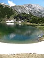
| location | at the Oberhüttensee; Sankt Johann im Pongau , Salzburg , Austria ; Valley location: Forstau | |
| Mountain range | Schladminger Tauern | |
| Geographical location: | 47 ° 16 '50.1 " N , 13 ° 35' 59.5" E | |
| Altitude | 1869 m above sea level A. | |
|
||
| owner | Franz Oberkofler family | |
| Construction type | Alpine hut | |
| Usual opening times | Mid June to mid October | |
| accommodation | 8 beds, 26 camps | |
| Web link | www.oberhuette.at | |
| Hut directory | PES | |

The Oberhütte is a refuge in the Schladminger Tauern in the Austrian state of Salzburg . It is located immediately north-northwest of the Oberhüttensee and the Oberhüttensattel at an altitude of 1869 m above sea level. A. , about halfway between the Ignaz-Mattis-Hütte and the winter sports resort Obertauern on the Tauern-Höhenweg , part of the Central Alpine Trail . It thus represents an alpine base on this route.
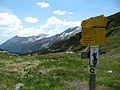
Access and tours
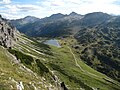
The ascent to the hut leads from Schladming in a westerly direction to Forstau , then in a southerly direction along the Forstaubach over the Vögeialm . Various tours and summit ascents are possible from the Oberhütte:
- Via the Seekarhaus from or to Obertauern 1½ hours.
- Via the Granglerhütte to Weißpriach 2½ hours.
- Ascent of the Styrian and Lungau Kalkspitze in about 1½ hours of walking.
Literature and map
- Hans Führer: Tauern-Höhenweg, from the Seckauer Tauern to the Venediger , Rother hiking guide, Munich 2005, ISBN 978-3-7633-4263-1
- Alpine Club Map 1: 50,000 sheets 45/2, Niedere Tauern II
Web links
Individual evidence
- ↑ Alpenverein, list of huts (queried on December 31, 2009)
- ↑ Homepage of the hut (requested on December 31, 2009)
- ↑ AEIOU about the Alm (queried on December 31, 2009)
- ↑ Austria Lexikon, Oberhüttensee, Walks (accessed on December 31, 2009)

Oberhüttensee

Oberhüttensee towards Meregg and Steirische Kalkspitze
Oberhüttensee against the Steirische and Lungauer Kalkspitze
Oberhüttensattel
View from Brotrinnl to Oberhütte (nsee)

Almidylle at the Oberhüttensee

Hut stamp


-Tiefblick.JPG)

