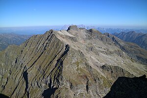
Elendberg
| Elendberg | ||
|---|---|---|
|
Elendberg from the Hochgolling -Nordwestgrat |
||
| height | 2672 m above sea level A. | |
| location | Styria , Austria | |
| Mountains | Schladminger Tauern , Lower Tauern | |
| Dominance | 1.7 km → Hochgolling | |
| Notch height | 346 m ↓ Gollingscharte | |
| Coordinates | 47 ° 17 '4 " N , 13 ° 44' 51" E | |
|
|
||
| rock | Migmatic paragneiss | |
The Elendberg is a 2672 m above sea level. A. high mountain in the Schladminger Tauern in the Austrian state of Styria . After the Hochwildstelle, it is the second highest peak on pure Styrian soil. The mountain gained fame in 1976 as the scene of a plane crash .
Location and surroundings
The Elendberg is the highest elevation of the Geinkelkamm, which extends south of Schladming in NNW- SSE direction and separates the Obertal from the Untertal. Neighboring peaks are the Zwerfenberg ( 2642 m ) in the south and the Pfeifer ( 2627 m ) in the northeast. To the south, the Gollingscharte ( 2326 m ) separates the ridge from the Hochgolling . The summit of the Elendberg is surrounded by karen all around , including the Kühkar on the east side and the Knappenkar and Elendkar on the west side (with Elendbergsee). The base for an ascent is the Gollinghütte .
Geology and geomorphology
The Elendberg is made up of migmatic paragneiss , which belongs to the Schladming crystalline complex. The piper and large parts of the adjacent Kühkar are made of plagioclase eye gneiss . There are local deposits of amphibolite bands . In the area north and south of the summit, a tectonic fault line runs orthogonally to the ridge . A total of six relict rock glaciers , which are made up of the Quaternary rubble inventory , are distributed over the cirques around the summit .
Plane crash
On June 4, 1976, a plane crash in Knappenkar at around 2500 m above sea level. A. four young men, including three Germans, killed. The 26-year-old pilot, the Austrian Hubert Fülle, started in Salzgitter with his friends between the ages of 23 and 33 and, after a stopover in Munich, was en route to Graz . The Morane MS 893 machine had already attracted attention in Upper Bavaria because of its low altitude. At around 4:30 p.m., the sports plane crashed on Elendberg. After the accident site was first suspected at Chiemsee or Waginger See , pilots from the Austrian Ministry of the Interior discovered the wreck after a two-day search in the Schladminger Tauern. Bad visibility ( cumulus clouds ) is assumed to be the cause of the crash .
A Marterl set up at the scene of the accident in 1977 reminds of the accident.
Ascent
The Elendberg is a popular winter peak. The most popular ascent takes 4½ hours from the Eschachalm in Obertal ( 1213 m ) through the Knappenkar, whereby the skis should be deposited under the summit depending on the conditions. The north-facing Elendbergrinne, which is up to 40 degrees steep, offers a demanding descent.
Since the mountain is not accessible by hiking trails, a summer ascent turns out to be arduous. The Eschachalm and the parking lot at the Riesach Falls ( 1079 m ) in Untertal or the Gollinghütte ( 1641 m ) can serve as starting points . From the Eschachalm, the ascent is first along the hiking trail to the Keinsprechthütte and then without a path through the Eiskar, then optionally through the Knappenkar or the Elendkar. The best way to ascend from the east is through the Kühkar, from the Gollinghütte you can expect 2½ hours.
On the summit there is a cassette with a summit book , but no summit cross .
Web links
Individual evidence
- ↑ Digital Atlas of Styria: Geology & Geotechnics. (No longer available online.) State of Styria , archived from the original on June 15, 2012 ; accessed on September 16, 2016 . Info: The archive link was inserted automatically and has not yet been checked. Please check the original and archive link according to the instructions and then remove this notice.
- ↑ Harald Kleinferchner: Block glacier inventory of the eastern Austrian Alps . Diploma thesis at the Institute for Geography and Spatial Research, University of Graz 2010, p. 60. [1]
- ↑ The Ennstaler. Weekly newspaper , edition of June 11, 1976 (vol. 71, no. 24), p. 1.
- ↑ Cumulus clouds killed airmen from Salzgitter. Salzgitter-Zeitung , accessed on September 16, 2016 .
- ↑ Günter and Luise Auferbauer: hike paradise Styria. All 2000s from Dachstein to Koralpe. Styria , Graz 2000, p. 226. ISBN 3-222-12783-2


