Pleschnitz tines
| Pleschnitz tines | ||
|---|---|---|
|
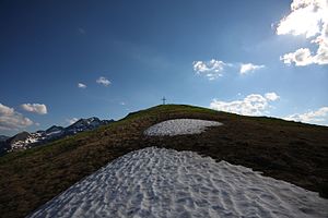
Summit slope and cross |
||
| height | 2112 m above sea level A. | |
| location | Styria , Austria | |
| Mountains | Hochwildstellen-Gruppe , Schladminger Tauern | |
| Coordinates | 47 ° 22 '22 " N , 13 ° 51' 22" E | |
|
|
||
The Pleschnitzzinken is a 2112 m above sea level. A. high summit of the Schladminger Tauern near Pruggern im Ennstal , Styria.
Location and landscape
The summit rises about 6 kilometers south of Pruggern, in the ridge between Seewigtal west and upper Sattental east. It forms a foothill to the Gamskarspitze ( 2491 m above sea level ) and belongs to the Schladminger Tauern group of high game sites. The saddle to the neighboring Scheibleck ( 2117 m above sea level ) is the Ochsenkarhöhe ( 1957 m above sea level ).
The ridge north-east leads down to the Kalteck ( 1968 m above sea level ), the north towards the Hühnerkogel ( 1602 m above sea level ).
The mountain forms the municipal boundary between Michaelerberg-Pruggern and Aich , between Pruggern and Gössenberg .
geology
The Pleschnitzzinkens area is formed from the Wölzer mica schist , which makes up the bulk of the eastern Niedere Tauern . The summit corridor itself is a block of quartzite that runs down into the Sattental.
To the northeast on the Galsterbergalm as well as to the west lie extensive glacial ceilings with moraines from the last Tauern glaciers.
Tours
The mountain is easy to climb. Paths lead up from Pruggererberg as well as from Gössenberg . North below is the Galsterbergalm (approx. 1800 m) on the Kalteck with the summit station of the Galsterberg ski area , directly on the north ridge is the Pleschnitzzinkenhütte ( 1944 m above sea level ), a self-catering hut of the Pruggern ÖAV section. An alternative ascent is via the Perneralm in the Sattental - Peterbaueralm - Ochsenkarhöhe and from the south to the Pleschnitzzinken.
Over the Ochsenkarhöhe you then get to the Scheibleck and Trifachkogel, and on to the Gamskarspitze (Schober). The following crossing to the Hochwildstelle ( 2747 m above sea level ) is high alpine.
The summit cross was only erected in 1976.
Web links
Individual evidence
- ^ Geological map of Austria.
- ↑ Pleschnitzzinken. In the Ennstalwiki .


