
Pruggern
|
Pruggern (former municipality) locality  Cadastral municipality Pruggern |
|||
|---|---|---|---|
|
|||
| Basic data | |||
| Pole. District , state | Liezen (LI), Styria | ||
| Judicial district | Schladming | ||
| Coordinates | 47 ° 25 ' N , 13 ° 52' E | ||
| height | 681 m above sea level A. | ||
| Residents of the village | 739 (January 1, 2020) | ||
| Building status | 249 (2001 ) | ||
| Area d. KG | 21.74 km² | ||
| Postcodes | 8965, 8962 Pruggern or Gröbming | ||
| prefix | + 43/3685 (Grobming) | ||
| Statistical identification | |||
| Community code | 61260 | ||
| Locality code | 15842 | ||
| Cadastral parish number | 67209 | ||
| Counting district / district | Pruggern (61260 001) | ||
 The Ennstal near Pruggern, behind the Kulm and the Kemet Mountains |
|||
| Independent municipality at the end of 2014 Source: STAT : Local directory ; BEV : GEONAM ; GIS-Stmk |
|||

Pruggern is a former municipality in the Ennstal in Styria as well as the capital , locality and cadastral municipality of the municipality of Michaelerberg-Pruggern in the Liezen district .
geography
Pruggern is located between Gröbming and Aich east of Schladming , not far from the entrance to the Sölk Pass .
The cadastral and village area covers an area of 21.74 km² and stretches in a narrow strip from the Enns on the left side of the Sattental to the ridge of the Schladminger Tauern , with the Hochwildstelle ( 2747 m above sea level ) as the highest point. To the north, the high altitudes on the Kulm , the mountain spur at the southern foot of the Kemet Mountains , belong to the area.
In addition to the town of Pruggern , the local area also includes the localities:
- Pruggererberg with the Pruggern hut village and the Vorderes Sattental on the southern shoulder of the Ennstal
- Schlatenbach on the south and Einöd on the north Enns side (the latter with districts in Gröbming )
- Kulm and Kunagrünberg am Kulm (the latter also has local parts in the municipality of Aich )
The alpine pastures in the village are Keinreiteralm, Perneralm, Peterbaueralm, Sattentalalm, Tagalm im Sattental, as well as Untere Galsterbergeralm and Obere Galsterbergeralm (with shelter) at high altitudes.
The Pruggern mountains belong to the Schladminger Tauern Hochwildstellen group , of which they form the north branch.

main place
| Pruggern ( village ) ( capital of the municipality ) | |
|---|---|
| Basic data | |
| Pole. District , state | Liezen (LI), Styria |
| Judicial district | Schladming |
| Pole. local community | Michaelerberg-Pruggern ( KG Pruggern , Michaelerberg ) |
| Locality | Pruggern , Michaelerberg |
| Coordinates | 47 ° 25 '28 " N , 13 ° 52' 26" E |
| height | 681 m above sea level A. |
| Building status | 98 (2016 ) |
| Statistical identification | |
| Counting district / district | Pruggern , Michaelerberg (61260 001, 000) |
 The village of Pruggern, against the Pruggererberg |
|
| Parts of the locality also in KG Michaelerberg ( ⊙ , until 2014 another municipality) Source: STAT : Local directory ; BEV : GEONAM ; GIS-Stmk |
|
The town of Pruggern lies on both sides of the Enns , the old town center is on the right bank (south bank). The border between Pruggern and Michaelerberg runs on the Sattentalbach through the built-up area of the village of Pruggern, so that the eastern part of the village of Pruggern is part of Michaelerberg.
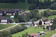
Enns Bridge Pruggern

On the B320 , view into the valley
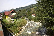
The Sattentalbach in Pruggern


history
Pruggern is - as the place name "Prugg" suggests - an important old bridge town. The Enns Bridge from Pruggern was already important in the High Middle Ages, and between Schladming and Admont Pruggern is the only place that lies on both sides of the Enns.
Pruggern municipality
The local congregation as an autonomous body was established in 1850 after the revolution . After the annexation of Austria in 1938, the community became part of the Reichsgau Steiermark, from 1945 to 1955 it was part of the British zone of occupation in Austria.
Until the end of 2014, Pruggern with its last 615 inhabitants (as of January 1, 2015) belonged to the Gröbming branch of the Liezen district and the Schladming judicial district .
On January 1, 2015, the municipality of Pruggern was merged with the municipality of Michaelerberg to form the new municipality of Michaelerberg-Pruggern as part of the Styrian municipal structural reform .
Population development
In 1869 the then municipality of Pruggern had 496 inhabitants. The highest level was in 1971 with 677 inhabitants, the lowest with 473 in 1900.
Religions
The majority of the population is Catholic. In 1781, when the tolerance patent was issued, a Protestant family lived in Pruggern (vulgo Huber). In 1844 a Protestant school was founded in Pruggern.
Economy and Infrastructure

The holiday village in the middle of the Dachstein-Tauern region, known for skiing, cycling and hiking, offers a comprehensive leisure program that is specially tailored to young families. The place belongs to the Schladming-Dachstein Tourist Association .
The most important tourism infrastructure is the Galsterberg ski area , which leads over the Hühnerkogel ( 1602 m above sea level ) to the Kalteck ( 1968 m above sea level ). It belongs to the Ski amadé network and is marketed as the "Gallic Ski Mountain" because it is one of the last autonomous small ski areas in the highly developed area of the Tauern from Upper Styria to Salzburg.
The Ennstalstraße B 320 runs north through Pruggern, while the Steinerstraße L 712 starts in Pruggern and leads back to the B 320 at Sankt Martin am Grimming via Stein an der Enns and Öblarn .
The Ennstalbahn Bischofshofen – Selzthal runs south of the Enns, Pruggern has a stop for regional trains.
The Sattentalbach is built with several small power plants, the Pruggern, Sattentalbach and Grießbach (in Vorderes Stattental) power plants of the Gröbming electricity works. Upstream of the Enns, the sewage treatment plant of the surrounding towns is still in the cadastral area.
Culture, sights and nature


The local chapel of the Holy Trinity is a listed building .
The rear Sattental with the Sattental-Almen is a scenic walking area, in the rearmost valley the Stierkarsee and the Goldlacken lie , already at the foot of the Hochwildstelle. This valley portions rearmost part of the nature reserve Bodensee-Sattenbachtal for Europe - bird sanctuary Niedere Tauern and the conservation area Schladming Tauern .
The Enns floodplains near Pruggern are also ecologically significant. Upstream from Schlatenbach , parts of the Friesacher Au nature reserve with protected parts of the Enns regulation-competing landscape fall into the area; downstream extends the Ennstal landscape from Ardning to Pruggern with part of the Ennstal European bird sanctuary between Liezen and Niederstuttern (meadows between Einöd, Thalhamm and Tunzendorf).
The Kulm is already part of the Dachstein-Salzkammergut landscape protection area .
For several years - if the weather is suitable - in the Sattental in Pruggern, the winterly icy trees have been staged with light, the event is called Eiswelt Pruggern .

In the back Sattental: Almen, Gamskarspitze - Umlaufer comb

The Stierkarsee


politics
The last mayor was Hannes Huber. After the elections in 2010, the local council composed as follows:
- 7 mandates of the Austrian People's Party (ÖVP)
- 2 mandates of the Social Democratic Party of Austria (SPÖ)
coat of arms
The coat of arms of the former municipality shows a bridge.
Web links
- 61241 - Pruggern. Community data, Statistics Austria .
Individual evidence
- ↑ a b Until the municipal consolidation in 2014, the place was in two municipalities
- ^ Announcement by the Styrian regional government of October 10, 2013 on the unification of the communities Michaelerberg and Pruggern, both political districts of Liezen. Styrian Provincial Law Gazette of November 15, 2013. No. 116, 32nd issue. ZDB ID 705127-x . P. 630.
-
↑ Ski Galsterberg (galsterberg.at) ;
Galsterberg , skiamade.com;
Galsterbergalm / Schladming ski area , bergfex.at. - ↑ H. and W. Senft: The most beautiful alpine pastures in Austria: Customs & Nature - Hiked and experienced. , Leopold Stocker Verlag, 2009, Upper Styrian Enns and Murtal: Sattental-Almen. ( online , at austria-forum).
- ↑ Eiswelt Pruggern. In the Ennstalwiki .