
Öblarn
|
market community Öblarn
|
||
|---|---|---|
| coat of arms | Austria map | |
 |
|
|
| Basic data | ||
| Country: | Austria | |
| State : | Styria | |
| Political District : | Liezen | |
| License plate : | GB | |
| Surface: | 70.17 km² | |
| Coordinates : | 47 ° 27 ' N , 14 ° 0' E | |
| Height : | 668 m above sea level A. | |
| Residents : | 2,035 (January 1, 2020) | |
| Postal code : | 8960 | |
| Area code : | 03684 | |
| Community code : | 6 12 62 | |
| NUTS region | AT222 | |
| Address of the municipal administration: |
Öblarn 47 8960 Öblarn |
|
| Website: | ||
| politics | ||
| Mayor : | Franz Zach ( ÖVP ) | |
|
Municipal Council : ( 2020 ) (15 members) |
||
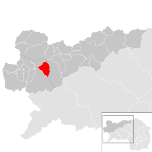
| Location of Öblarn in the Liezen district | ||
  |
||
 Municipal Office |
||
| Source: Municipal data from Statistics Austria | ||

Öblarn is a market town with 2035 inhabitants (as of January 1, 2020) in Styria ( Schladming judicial district ). Since January 1, 2015 it has been merged with the Niederöblarn community as part of the Styrian community structural reform and continues to use the name "Öblarn".
geography
Community structure
The municipality includes the following six localities (population in brackets as of January 1, 2020):
- Gritschenberg (95) including Zamberg and Zeissenberg
- Moosberg, also Sonnberg (29)
- Niederoblarn (471)
- Öblarn (1053) including the stream
- Sonnberg (377) including Edling, Schattenberg and Walchen
- Straßerberg (10)
The municipality consists of the three cadastral municipalities (area 2015):
- Öblarn (391.84 ha)
- Niederöblarn (2,090.34 ha)
- Sonnberg (4,539.23 ha)
Neighboring communities
| Mitterberg-Sankt Martin | ||
.svg)
|
Irdning-Donnersbachtal | |
| Sölk |
history

Historical overview
- 1434: A smelter in the Walchen is mentioned for the first time in a land register.
- 1469: Documentary evidence of the granting of mining rights by the Abbot of Admont to Jakob Schauer, Paul Rieder and Peter zu Talern. The original document is in the archive of Admont Abbey .
- 1552: The trades Lukas Sitzinger and Andreas Prantmayr from Nuremberg take over mining in the Walchen.
- 1565: The Verweserhaus (today the lordship or administrative building) is built. This building housed the mining administration and its size still shapes the market square of Öblarn today.
- 1656: Johann Feuersänger from Salzburg directs the fortunes of the Walchen mining industry for several years, but without success.
- 1666: Hans Adam Stampfer takes over the severely run-down business. For 136 years, his family led the mining and smelting operations to peak. In the second half of the 17th and 18th centuries, mining in Öblarn became known throughout the German-speaking world. The Stampfer process of ore roasting and smelting rosette copper found particular recognition. As a result of this fame, Hans Adam Stampfer and his successors were raised to the nobility and were allowed to bear the title "Count of Walchenberg". The wife of Hans Adam Stampfer, Maria Elisabeth Stampfer, née Dellatore, described the takeover time of the Walchener Bergbau in detail and in a very interesting way in her “ Hausbüchl der Stampferin ”.
- 1802: Count Batthyány has a difficult career after the Stampfer dynasty and fails.
- 1819: The Ritter von Fridau, two brothers, try to help the impoverished community and revive mining and production at great sacrifice.
- 1848: Abolition of the manorial system.
- 1850: The local congregation is established as an autonomous body.
- 1858: A lack of coal and difficult processing of the complex ores force the mining and smelting operations to close. Since then, the roasting halls and smelting furnaces have been left to decay.
- 1891: Leonard Brigl resumes mining for the extraction of pyrites, which he needs to convert cellulose in his paper industry in Niklasdorf .
- 1939: After the annexation of Austria (March 1938) the federal state of Reichsgau Styria becomes the district of Liezen.
- 1945: After the end of the Second World War, Öblarn lies in the British zone of occupation until 1955.
- 1958: After a few interruptions, the mining operations are finally closed this year.
- 1998: With the help of the market town of Öblarn, the Province of Styria and the Austrian Federal Monuments Office, the newly founded mining association Öblarn stops the decline and begins the maintenance work on the mining historical sites.
- 2008: After ten years of hard and consistent work, a good part of the historic ore mining and metal processing plants can make the former size and importance of mining in the Walchen visible again. Today, the Thaddäusstollen, the large roasting barn or "sulfur furnace", the copper furnace and the unique silver burner stove have been manufactured to such an extent that the copper, silver and sulfur extraction process of the 17th, 18th and 19th centuries is easy to imagine.
Copper mining and processing in Öblarn
Öblarn was an important mining town for several centuries. His products gained recognition far beyond what is now Austria.
The copper trail show path begins in the center of Öblarn at the former Verweserhaus, now the “Herrschaftsamt”, and leads south into the Walchental. 14 stations are marked as such.
Culture and sights
- Parish church hl. Andreas
- Calvary
- church Square
- Rectory, originally a school building
- The forestry office on Kirchplatz, the former steward's house of the mining operations, also known as the “Herrschaftsamt”, dates back to the 17th century.
- Mining historical show path Öblarner Kupferweg
- Wooden chapel in the Walchen
Museums
- Paula Grogger Museum in the writer's former home
- Beekeeping Museum with a collection of old beekeeping tools
Regular events
- Annual sheep farming day
- Öblarner Festspiele: Paula Grogger's wedding has been performed every five years since 1992, before that at irregular intervals since 1937.
politics
The municipal council has 15 members.
- With the municipal elections in Styria in 2015 , the municipal council had the following distribution: 8 ÖVP, 4 SPÖ, 2 citizen list Anton Knerzl and 1 FPÖ.
- With the municipal council elections in Styria 2020 , the municipal council has the following distribution: 8 ÖVP, 6 SPÖ and 1 FPÖ.
mayor
- 1965–1981 Josef Rammer
- 1981–1990 Albert Ertlschweiger (SPÖ)
- 1990–2000 Elisabeth Köberl (ÖVP)
- 2000-2006 Anton Knerzl (FPÖ, BZÖ)
- 2006–2008 Ehrenfried Lemmerer (SPÖ)
- since 2008 Franz Zach (ÖVP)
coat of arms
The municipal coat of arms was awarded with effect from October 1, 1996.
Due to the amalgamation of the municipalities, the coat of arms lost its official validity on January 1st, 2015. The re-award took place with effect from November 1, 2015.
The new blazon is:
- "In an ermine shield there are two red posts and a silver St. Andrew's cross bordered with black thread inside, leaving the flanks free."
Personalities
Honorary citizen
- 1972: Ferdinand Tremel (1902–1979), university professor, member of the State Historical Commission for Styria

Sons and daughters of the church
- Paula Grogger (1892–1984), writer
- Ferdinand Tremel (1902–1979), university professor, member of the State Historical Commission for Styria
- Anton Egger (* 1932), professor emeritus for business administration
- Helmut Madl (* 1942), Old Testament scholar
- Hermann Flaschka (* 1945), mathematician and physicist
- Peter Haubenwallner (* 1945), university lecturer, director of the pension office and the main welfare office in Munich
- Eduard Nicka (* 1945), FPÖ politician
- Klaus Kröll (* 1980), ski racer
- Johannes Kröll (* 1991), ski racer
- Manuel Traninger (* 1998), ski racer
literature
- Bundesdenkmalamt (Ed.): Dehio manual. The art monuments of Austria: Styria (excluding Graz). Öblarn. Verlag Berger, Horn / Vienna 1982/2006, 2nd unchanged edition, p. 345ff, ISBN 3-85028-422-0 .
Web links
- 61228 - Öblarn. Community data, Statistics Austria .
- Website of the market town of Öblarn
- Website of the Öblarner Kupferweg
- Steiermark360, 360 ° panorama Öblarn (aerial view)
Individual evidence
- ↑ Announcement of the Styrian state government of October 17, 2013 on the unification of the market community Öblarn and the community Niederöblarn, both political district Liezen. Styrian Provincial Law Gazette of November 15, 2013. No. 124, 32nd issue. ZDB ID 705127-x . P. 632.
- ↑ Statistics Austria: Population on January 1st, 2020 by locality (area status on January 1st, 2020) , ( CSV )
- ↑ cadastral communities Styria. 2015 (Excel file, 128 KB); Retrieved July 29, 2015
- ↑ Öblarn Festival. Retrieved November 28, 2017 .
- ^ Election results for the 2015 municipal council elections in Öblarn. State of Styria, March 22, 2015, accessed on July 26, 2020 .
- ↑ Results of the local council election 2020 in Öblarn. State of Styria, June 28, 2020, accessed on July 26, 2020 .
- ↑ 86. Announcement of the Styrian state government of October 8, 2015 on the granting of the right to use a municipal coat of arms to the market town of Öblarn (political district Liezen) , accessed on October 13, 2015
- ↑ Südost-Tagespost (May 17, 1972), p. 7.

Liezen area: Admont | Aigen im Ennstal | Altaussee | Altenmarkt near Sankt Gallen | Ardning | Bad Aussee | Bad Mitterndorf | Gaishorn am See | Grundlsee | Irdning-Donnersbachtal | Landl | Lassing | Liezen | Rottenmann | Sankt Gallen | Selzthal | Stainach-Pürgg | Shoots | Wild Alps | Wörschach
Area Expositur Gröbming : Aich | Grobming | House | Michaelerberg-Pruggern | Mitterberg-Sankt Martin | Öblarn | Ramsau am Dachstein | Schladming | Sölk