Niklasdorf
|
market community Niklasdorf
|
||
|---|---|---|
| coat of arms | Austria map | |
|
|
||
| Basic data | ||
| Country: | Austria | |
| State : | Styria | |
| Political District : | Leoben | |
| License plate : | LN | |
| Surface: | 15.13 km² | |
| Coordinates : | 47 ° 24 ' N , 15 ° 9' E | |
| Height : | 521 m above sea level A. | |
| Residents : | 2,382 (January 1, 2020) | |
| Postal code : | 8712 | |
| Area code : | 03842 | |
| Community code : | 6 11 10 | |
| NUTS region | AT223 | |
| UN / LOCODE | AT NKD | |
| Address of the municipal administration: |
Hauptplatz 1 8712 Niklasdorf |
|
| Website: | ||
| politics | ||
| Mayor : | Johann Marak ( SPÖ ) | |
|
Municipal Council : (2015) (15 members) |
||
| Location of Niklasdorf in the Leoben district | ||
| Source: Municipal data from Statistics Austria | ||
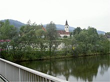
Niklasdorf is a market town with 2382 inhabitants (as of January 1, 2020) in the judicial district and district of Leoben , state of Styria , Austria .
geography
Location and landscape
Niklasdorf is located in the Upper Styrian Murtal, around seven kilometers east of Leoben and ten kilometers west of Bruck an der Mur . The municipality covers 15.13 km² and is located at an altitude of 527 m in the town center. The northern border of the municipality forms the Mur over a length of more than one kilometer. The neighboring communities are Leoben and Proleb in the Leoben district and Oberaich in the Bruck-Mürzzuschlag district .
Far more than half of the municipality consists of forest areas, around a fifth of fields, meadows and approx. 50 hectares of alpine pastures .
structure
The community includes the village of Niklasdorf and consists of three cadastral communities (area 2015):
- Foirach (273.99 ha)
- Niklasdorf (344.42 ha)
- Niklasdorfgraben (894.10 ha)
climate
A continental climate with relatively warm summers, but frequent ingress of cold air and summer rain prevails, the winters are quite severe and sometimes show quite large temperature fluctuations. Precipitation is relatively low.
history
Early history
Archaeological excavations prove the settlement of the region since the earliest times. From the Paleolithic and Middle Stone Age (100,000-4,000 BC), some bone tools were discovered in the surrounding caves (e.g. the Dragon Cave near Mixnitz ). The most famous find from this time in the Niklasdorf municipality is a molar of a mammoth. In the Neolithic Age (4,000-2,300 BC) rural settlement began in Upper Styria. Numerous stone axes were found in the nearby Mühltal and Nennersdorf (municipality of Leoben).
The Bronze Age (2,300-1,200 BC) is often seen as the beginning of mining and metallurgy, which has been of great economic and cultural importance in this region since then (Styrian Iron Road ). Precious finds in the Leoben district attest to this (e.g. a handle-tongue sword from Donawitz ). The discovery of two needles for clothing comes from Niklasdorf.
Antiquity
With the increasing number of iron grave goods, a new era began ( Iron Age - from 800 BC). Around the 4th century. v. Through the immigration of the Celts, the Illyrian population was mixed and the Kingdom of Noricum was founded. Noricum was founded in 15 BC. Part of the Roman Empire under Emperor Augustus (63 BC-AD 16 ) and a Roman province under Claudius (AD 41–54). A relic from this time is the Roman bridge near St. Dionysen.
During the Roman Empire, the Leoben area was largely part of the extensive urban district of Flavia Solva near Leibnitz (south of Graz ), and a smaller part of that of Lauriacum ( Lorch , Upper Austria). Roman inscription stones from the Leoben area are known from this time.
Middle Ages - Duchy of Carantania and Carolingian-Franconian rule
After the fall of the Roman Empire, Slavic population groups settled in the region in the 6th century and founded the Duchy of Carantania (later Carinthia). Numerous place and field names from the Niklasdorf area have been preserved to this day (e.g. Leoben, Donawitz, Proleb, Mötschlach, Mugel, etc.), with the Slavic names dominating along the old Roman road west of the Mur. German settlement names predominate east of the Mur.
In the 8th century the Carantans pushed back the invading Avars with the help of the Bavarians and thus came under Bavarian suzerainty and from 788 under Carolingian-Franconian rule. From this time grave fields were discovered in the towns of Proleb, Trofaiach and Brunn near St. Michael near Niklasdorf . In 828, Carantania became Bavarian again.
Starting with the diocese of Salzburg in the 8th century, Christian missionary work began in Upper Styria and the first churches emerged. In 860 a deed of donation from King Ludwig the German to the Archbishopric of Salzburg named the towns of St. Michael ob Leoben (ad Liestinicham) and Bruck (ad Pruccam), where there were apparently Carolingian manors. St. Michael is the original parish for the later Niklasdorf.
On March 10, 904 in Ingolstadt, King Ludwig gave the child (the only legitimate son of Emperor Arnulf of Carinthia ) to Aribo II (Count of Göss-Schladnitz) 20 Huben with a walled yard at the mouth of the Schladnitz as a free property. Starting from this farm, Aribo took land downriver on both sides of the Mur 1800 Joch . Depending on the research opinion, it could be the later cadastral communities Schladnitz, Schladnitzgraben, Göss, Gössgraben, Leoben, Mühltal, Niklasdorf, Niklasdorfgraben, Foirach, Streitgarn , Forstwald, Oberaich or Leitendorf, Waasen-Vorstadt, perhaps part of Donawitz, Picheldorf and Oberdorf have acted. Although only the Hof zu Schladnitz was mentioned in a document, one can assume that there are several farmsteads, since Aribo II. Was given the selected land "cum curtilibus", i.e. with the farms on it. Parts of these manor houses, which are unique in Upper Styria, have been preserved to this day as so-called "Moarhöfe" ( "Meierhöfe" ).
In 1004 the Göss Monastery , the oldest monastery in Styria, was founded. On April 13, 1148, the possessions of the monastery in Reims, France, were bought by Pope Eugene III. confirmed, including the "ecclesia Sancti Nicholai de Michlindorfr". This is the oldest known document from Micheldorf, today's Niklasdorf. (The earlier name - as in the case of other place names - goes back to the Old High German word "mihhil" with the basic meaning 'large', thus suggesting a more important settlement compared to the surrounding area.) Niklasdorf took this first documentary mention 1998 the occasion for the 850th anniversary of the community.
population
Population development

| Population by marital status Source: Statistics Austria (2001) |
||||||
|---|---|---|---|---|---|---|
| feature | in % | total | Men | Women | ||
| single | 36.9 | 996 | 548 | 448 | ||
| married | 44.0 | 1187 | 598 | 589 | ||
| widowed | 11.2 | 301 | 53 | 248 | ||
| divorced | 7.9 | 213 | 89 | 124 | ||
With 2537 inhabitants (as of January 1, 2016) Niklasdorf ranks fifth among the most populous municipalities in the Leoben district. It is also the most populous market town in the district after St. Michael in Upper Styria . In 1971 Niklasdorf reached the highest population in its history with 3,365 inhabitants. The steady population decline that has existed since then is the result of a high emigration rate (−5% 1991–2001) and a low birth rate (−4.4% 1991–2001). The population density is around 170 inhabitants per square kilometer.
Population by age group
| Population by age group (in years) Source: Statistics Austria (2008) |
||||||
|---|---|---|---|---|---|---|
| feature | in % | total | Men | Women | ||
| until under 15 | 11.9 | 306 | 153 | 153 | ||
| 15 to 64 | 65.5 | 1685 | 836 | 849 | ||
| 65 and older | 22.6 | 583 | 230 | 353 | ||
The population is made up of 52.6% (1355) women and 47.6% men (1219), which results in a slight surplus of 136 female residents (as of 2008). This is due to the generally higher life expectancy of women. From the age of 60 onwards, the female population has increased.
Quota of foreigners
The foreigner quota of 5.2% (133) is higher than the national average due to the location as an industrial location similar to the district capital Leoben. While in 1991 only 2.3% (1717) non-Austrians were registered in the Leoben district, the number had roughly doubled by 2008. Since Niklasdorf, together with Leoben, Vordernberg , St. Michael and Eisenerz, is hardest hit by the emigration of domestic citizens, external immigration has a positive net effect in demographic terms. It curbs the population loss and contributes to improving the age structure. Most of the non-Austrians come from the former Yugoslavia (84), followed by Turkey (12) and Germany (10). 8.1% (208) did not have Austrian citizenship at birth.
languages
95% of the population of Niklasdorf speak German as their mother tongue with regional dialects from Upper Styria, followed by languages from the former Yugoslavia (especially Croatian , Bosnian and Slovenian ). The third strongest language is Turkish . About 30 residents have a different mother tongue.
religion
The majority of the population professes the Roman Catholic Church. Already at the end of the 11th century the church called “St. Nikolaus in Micheldorf ”by the Göss Monastery. Members of the Protestant faith are clearly in the minority and do not have their own place of worship in the community area. Islamic believers and Christian Orthodox are only slightly represented. The number of those with no religious affiliation is well over 10% and the trend is increasing.
politics
Regional policy
Niklasdorf belongs to the LEADER region Steirische Eisenstraße and to the 18th Nov. 2009 Regionext small region Murtal around Leoben. With the municipal structural reform of Styria 2010-2015 , the market municipality will probably remain independent.
coat of arms
The municipal coat of arms was awarded with effect from July 1, 1968.
Blazon :
- "In a shield divided by white and green obliquely to the left, three red balls abutting against each other, below a silver roll of paper placed obliquely to the left."
The three balls (breads) are the attribute of St. Nicholas, whose patronage has replaced the old place name "Michilindorf". The paper roll refers to the cellulose and paper factory Brigl & Bergmeister A. G., the important industrial company located within the municipality.
Culture and sights
Gate to Eisenstraße (design: Georg Brandner)
Pedestrian bridge to Köllach
Personalities
Sons and daughters of the church
- Herwig Ebner (1928–2010), historian
- Adelheid Fürntrath-Moretti (* 1958), ÖVP politician , member of the National Council 2006–2013
- Fritz Goergen (* 1941), publicist
- Alfred Heindler (1927–2005), politician, humorist
- Ernst Leitner (1912 – unknown), athlete
- Alarich Wallner (1922–2005), composer, conductor
Personalities associated with the community
- Johanna Schicker (* 1943), SPÖ politician , member of the Federal Council 1986–2004
- Kathrin Steinberger (* 1982), author of books for children and young people
Web links
- 61110 - Niklasdorf. Community data, Statistics Austria .
- Entry on Niklasdorf in the Austria Forum (in the AEIOU Austria Lexicon )
- Website of the market town
Individual evidence
- ↑ Gerhard Köbler: Old High German Dictionary, 3rd edition 1994. (PDF; 790 kB)
- ↑ The new municipal structure of Styria ( Memento of the original from July 29, 2013 in the Internet Archive ) Info: The archive link was inserted automatically and has not yet been checked. Please check the original and archive link according to the instructions and then remove this notice. . List of final version A01, 2012 (pdf, gemeindeststrukturreform.steiermark.at; 97 kB).


