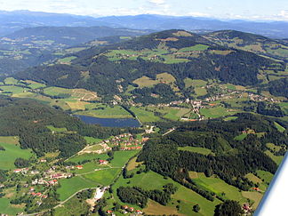
Wimitz Mountains
| Wimitz Mountains | |
|---|---|
|
The Wimitzer Mountains near Sankt Urban |
|
| Highest peak | Schneebauerberg , Hocheck ( 1338 m above sea level ) |
| location | Carinthia , Austria |
| part of | Gurktal Alps |
| Coordinates | 46 ° 48 ' N , 14 ° 15' E |
The Wimitzer Mountains are the part of the Gurktal Alps that is enclosed by the Gurk and Glan rivers . The Wimitz Valley divides the Wimitz Mountains into two parallel ridges: the Zammelsberger Ridge in the north and the Schneebauer Ridge (also known as the Sörger Mountains) in the south. The highest peaks are the Schneebauerberg ( 1338 m above sea level ) and the Hocheck in the Simonhöhe ski area (also 1338 m above sea level ).
photos
Individual evidence
- ↑ Paul Gleirscher : The fortifications on Ottilienkogel near Glantschach above Liebenfels . In: Kärntner Landesmuseum (Ed.): Rudolfinum. Yearbook of the State Museum for Carinthia . tape 2009_2010 , p. 35–50 ( PDF on ZOBODAT [accessed March 25, 2014]).
- ↑ Sea of Fog. Retrieved March 25, 2014 .
- ↑ a b HIKING IN CARINTHIA. Retrieved March 25, 2014 .


