
Sankt Urban (Carinthia)
|
Santa Urban
|
||
|---|---|---|
| coat of arms | Austria map | |
 |
|
|
| Basic data | ||
| Country: | Austria | |
| State : | Carinthia | |
| Political District : | Feldkirchen | |
| License plate : | FE | |
| Surface: | 27.24 km² | |
| Coordinates : | 46 ° 45 ′ N , 14 ° 10 ′ E | |
| Height : | 792 m above sea level A. | |
| Residents : | 1,527 (January 1, 2020) | |
| Population density : | 56 inhabitants per km² | |
| Postal code : | 9554 | |
| Area code : | 0 42 77 | |
| Community code : | 2 10 08 | |
| NUTS region | AT212 | |
| Address of the municipal administration: |
Dorfplatz 1, A-9554 St. Urban | |
| Website: | ||
| politics | ||
| Mayor : | Dietmar Rauter ( FPÖ ) | |
|
Municipal Council : ( 2015 ) (15 members) |
||
| Location of Sankt Urban in the Feldkirchen district | ||
  |
||
 A bird's eye view of Sankt Urban |
||
| Source: Municipal data from Statistics Austria | ||

Sankt Urban is a municipality with 1527 inhabitants (as of January 1, 2020) in the Feldkirchen district in Carinthia .
geography
Sankt Urban is located in the Gurktal Alps in northern Central Carinthia, about 10 km northeast of Feldkirchen . The community is located on the St. Urbaner See . The community area is 520 m (in the Glantal) to 1338 m above sea level (Hocheck, Simonhöhe ).
Community structure
Sankt Urban is divided into the five cadastral communities of Bach, Hafenberg, Rasting, St. Urban and Zirkitz. The municipality includes the following 28 localities (population in brackets as of January 1, 2020):
- Agsdorf (340)
- Agsdorf area (120)
- Bach (142)
- Bach-St. Urban (61)
- Buggl in Bach (9)
- Harrows (2)
- Gall (42)
- Gasmai (16)
- Goeschl (10)
- Goessberg (4)
- Grai (8)
- Hafenberg (48)
- Kleingradenegg (2)
- Lawesen (8)
- Oberdorf (259)
- Reggen (61)
- Retschitz (55)
- Retschitz-Simonhöhe (7)
- Rittolach (4)
- Rye (49)
- St. Paul (5)
- St. Urban (31)
- Simonhöhe (45)
- Stattenberg (47)
- Trenk (93)
- Tumbler (15)
- Zirkitz (26)
- Zwattendorf (18)
Another location is the hamlet of Doppler in Agsdorf.
Neighboring communities
| Steuerberg | Frauenstein | |
.svg)
|
Liebenfels | |
| Feldkirchen | Glanegg |


history
References to the first settlements in what is now the municipality come from the Bronze Age . A Roman Mithras cult site in a rock cave on the Brockenwand is estimated to be around the year 250, but there are no indications of a closed settlement during this time.
The oldest written mention of the church sanctus urbanus comes from the year 1164, since the year 1169 St. Urban has been an independent parish. At that time, the majority of the population was subject to Ossiach Abbey . Documents about the Hafnerburg, ducal ministerials who built the Hafnerburg , also date from the 12th century .
In the late 15th century there were Turkish invasions . In the 16th and 17th centuries gold and copper mining played an important role on the Gößberg.
The political community of St. Urban was constituted in 1849/50. The extent of the municipality has not changed since then, apart from a minor correction in favor of the municipality in 1973.
population
At the 2001 census, Sankt Urban had 1,440 inhabitants, 96.0% of whom were Austrian and 1.6% German . 90.8% of the population confessed to the Roman Catholic and 4.4% to the Protestant Church, 2.6% were without religious beliefs.
Culture and sights
- Parish church of St. Urban , late Gothic church building in Baroque style, first mentioned in a document in 1164, rebuilt and expanded in the first quarter of the 16th century, restored in 1957. The choir and choir tower date from the 14th century.
- The Bach Castle , a Renaissance building with shingle roof from the first half of the 16th century, is located on a hillside north of St. Urban lake.
- The remains of the Hafnerburg can also be found in the municipality.
- A Mithras cult site is located in a natural rock cave on the south side of the Brockenwand, above Lake Urban. A simple image of the sun god Mithras is carved into the rock on the east side .

Mithras rock

Memorial plaque at the Mithras cult site
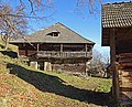
Decaying homestead in Zirkitz


Dobra Moor
The Dobra Moor (other names are Jakobimoor or Freundsamer Moos) is located at an altitude of 902 m. Surrounded by rolling hills and mountains, such as Gößberg, Paulsberg and Illmitzer Wald, it is the habitat for a species-rich flora that is typical for moors. This moor is also home to the Nordic birch, a holdover from the Ice Age, and was only discovered in Carinthia in 1922.
Economy and Infrastructure
Agriculture and forestry are predominant. Summer (lake) and winter tourism (Simonhöhe ski area) also play a role.
politics
The municipal council of St. Urban has 15 members and has been composed as follows since the municipal council election in 2015 :
- mayor
- until 2009 Hermann Huber (SPÖ)
- since 2009 Dietmar Rauter (BZÖ or FPÖ)
coat of arms
A coat of arms of the ministerial family who lived in the Hafnerburg in the Middle Ages was first handed down on May 4, 1230, but it was adopted by the Himmelbergers before 1322 and has been the coat of arms of the Himmelberg community since 1960 . St. Urban therefore only has part of this coat of arms. the silver diagonal right bar in red.
The municipality's coat of arms and flag were awarded on September 10, 1990. The official blazon of the coat of arms is as follows:
"In red a silver diagonal bar, accompanied by a silver sun at the top and a silver branch of the birch tree (betula humilis) with two silver leaves at the bottom."
The silver sun alludes on the one hand to the Mithras inscription on a Roman stone found in the 19th century at the inn in St. Urban, but can also be interpreted as a symbol for tourism. The Nordic bush birch ( betula humilis ) in the lower part of the coat of arms is a specialty in the Dobramoor or Freudsamer Moos, a moor in the municipality that was created and preserved from the meltwater of the Ice Age.
The flag is white and red with an incorporated coat of arms.
Personalities
- Valentin Stubinger (* 1959) nationally known entertainer
- Engelbert Brenter (1897–1976), Austrian inventor and entrepreneur
- Erik Schinegger (* 1948 in Agsdorf), former Austrian ski racer
- Alfons Marktl, curling world champion 2016
Web links
- St. Urban parish
- 21008 - Sankt Urban (Carinthia). Community data, Statistics Austria .
- The Worm Ice Age Dobramoor on the edge of the Draugletscher
Individual evidence
- ↑ Statistics Austria: Population on January 1st, 2020 by locality (area status on January 1st, 2020) , ( CSV )
- ^ Statistics Austria, population census, demographic data. May 15, 2001, accessed March 3, 2019 .
- ^ Dehio manual. The art monuments of Austria. Carinthia , p. 837 f. Anton Schroll, Vienna 2001. ISBN 3-7031-0712-X
- ↑ Huber found his "master" in Rauter . Article dated March 16, 2019, accessed April 21, 2018.
- ↑ orf.at: Results of the mayor's runoff elections . Article dated March 15, 2009, accessed April 21, 2018.
- ↑ FPÖ-Darmann: With Dietmar Rauter, one of the most successful liberal mayors of Austria becomes the new Federal Councilor! . OTS bulletin of March 14, 2017, accessed April 21, 2018.
- ^ Quoted from Wilhelm Deuer: The Carinthian municipal coat of arms . Verlag des Kärntner Landesarchiv, Klagenfurt 2006, ISBN 3-900531-64-1 , p. 256
Albeck | Feldkirchen | Glanegg | Gnesau | Himmelberg | Ossiach | Reichenau | Santa Urban | Steindorf am Ossiacher See | Steuerberg