
Fischa
| Fischa | ||
 The Fischa in the Mitterndorf / Fischa area |
||
| Data | ||
| location | Vienna Basin , Lower Austria | |
| River system | Danube | |
| Drain over | Danube → Black Sea | |
| source |
Haschendorf im Steinfeld 47 ° 52 ′ 35 ″ N , 16 ° 19 ′ 32 ″ E |
|
| Source height | 235 m above sea level A. | |
| muzzle | at Maria Ellend in the Danube Coordinates: 48 ° 7 '10 " N , 16 ° 40' 35" E 48 ° 7 '10 " N , 16 ° 40' 35" E |
|
| Mouth height | 149 m above sea level A. | |
| Height difference | 86 m | |
| Bottom slope | 2.5 ‰ | |
| length | 35 km | |
| Catchment area | 563.1 km² | |
| Small towns | Ebreichsdorf , Fischamend | |
| Communities | Ebenfurth , Pottendorf , Unterwaltersdorf , Mitterndorf an der Fischa , Reisenberg , Gramatneusiedl , Ebergassing , Schwadorf , Enzersdorf an der Fischa , Klein-Neusiedl , Haslau-Maria Ellend | |
| The area where it flows into the Danube was previously used as a protective port. | ||
The Fischa is a right tributary of the Danube in eastern Lower Austria .
Run and landscape
The Fischa rises in the cadastral municipality of Haschendorf in the municipality of Ebenfurth . It drains the so-called Wöllersdorfer rubble cone , whereby the groundwater from deep springs in the Vienna basin collects in two trenches. This makes the Fischa a water-rich river despite its shortness. The only significant tributary, the Piesting , on its way to the confluence with the Fischa, is several times longer than the Fischa itself, but it has less water. The Fischa flows through the Steinfeld and flows into the Danube below Fischamend .
The moist soil around the river causes the appearance of numerous extensive meadows with individual trees or groups of trees. In its lower reaches, the Fischa is surrounded by swamps . Like the Schwechat , it has a dragged estuary , which means that it uses an old arm of the Danube on its last section.
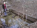
Origin of the Fischa

Confluence with the Danube


About the name
Already in 1063 is at the Fischa - "iuxta flumen Fisek" of - King Henry IV. A diploma in favor of the Bishopric of Brixen issued. Not far from the Fischa there is the Warme Fischa , which flows from Bad Fischau through Wiener Neustadt and flows into the Leitha at Pottendorf . That is why the Fischa is also referred to as Fischa-Dagnitz to distinguish it , whereby the word part Dagnitz refers to the now no longer existing settlement Tagais in the area of Haschendorf.
Hydrography and water use
The water level and temperature are constant throughout the year, which makes them useful for industrial purposes. The important Marienthal spinning mill was located on the river. At Fischamend it has an average water volume of 7.5 cubic meters per second.
Web links
Individual evidence
- ↑ BMLFUW (Hrsg.): Area directory of the river areas: Danube area from the Enns to the Leitha. In: Contributions to Austria's hydrography, issue 62, Vienna 2014, p. 121. PDF download , accessed on July 8, 2018.
- ↑ Martin Bitschnau , Hannes Obermair : Tiroler Urkundenbuch, II. Department: The documents on the history of the Inn, Eisack and Pustertal valleys. Volume 1: By the year 1140 . Universitätsverlag Wagner, Innsbruck 2009, ISBN 978-3-7030-0469-8 , p. 208-209, No. 233 .
- ↑ Reinhard Müller : Fischa ( Memento from February 3, 2010 in the Internet Archive ). Archive for the History of Sociology in Austria.