
Wolfsberg (Carinthia)
|
Borough Wolfsberg
|
||
|---|---|---|
| coat of arms | Austria map | |
_COA.svg) |
|
|
| Basic data | ||
| Country: | Austria | |
| State : | Carinthia | |
| Political District : | Wolfsberg | |
| License plate : | WHERE | |
| Surface: | 278.63 km² | |
| Coordinates : | 46 ° 51 ' N , 14 ° 50' E | |
| Height : | 463 m above sea level A. | |
| Residents : | 25,025 (January 1, 2020) | |
| Postal code : | 9400 | |
| Area code : | 04352 | |
| Community code : | 2 09 23 | |
| NUTS region | AT213 | |
| Address of the municipal administration: |
Rathausplatz 1 9400 Wolfsberg |
|
| Website: | ||
| politics | ||
| Mayor : | Hannes Primus ( SPÖ ) | |
|
Municipal Council : ( 2015 ) (35 members) |
||
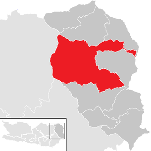
| Location of Wolfsberg in the Wolfsberg district | ||
  |
||
| Source: Municipal data from Statistics Austria | ||


Wolfsberg is a town with 25,025 inhabitants (1 January 2020) and the seat of the district administration of the eponymous district in Carinthia .
geography
The community is located in the middle of the Lavant valley . It covers large parts of the Saualpe . Two foothills of the municipality extend to the Koralpe , which largely enclose the municipality of Frantschach-Sankt Gertraud .
Community structure
The municipality consists of 40 cadastral municipalities (area as of December 31, 2019):
- Aichberg (1,897.01 ha)
- Floodplains (600.55 ha)
- Forest (2,458.67 ha)
- Gräbern-Prebl (1,495.09 ha)
- Gries (93.78 ha)
- Hartelsberg (1,188.11 ha)
- Hattendorf (243.20 ha)
- Hintertheißenegg (1,444.63 ha)
- Kleinedling (435.20 ha)
- Kleinwinklern (48.62 ha)
- Lading (2,335.45 ha)
- Leiwald (1,428.66 ha)
- Michaelsdorf (348.40 ha)
- Oberleidenberg (1,162.33 ha)
- Paildorf (138.81 ha)
- Pfaffendorf (101.08 ha)
- Preims (1,939.64 ha)
- Priel (296.13 ha)
- Reding (149.89 ha)
- Reideben (114.35 ha)
- Reisberg (1,245.59 ha)
- Rieding (1,210.13 ha)
- Ritzing (92.89 ha)
- St. Jakob (107.35 ha)
- St. Johann (112.12 ha)
- St. Marein (110.33 ha)
- St. Margarethen (237.03 ha)
- St. Michael (470.82 ha)
- St. Stefan (732.21 ha)
- Schossbach (14.49 ha)
- Alluvial rats (45.88 ha)
- Thürn (516.80 ha)
- Unterleidenberg (334.56 ha)
- Vordergumitsch (545.23 ha)
- Vordertheißenegg (778.12 ha)
- Waldenstein (1,019.73 ha)
- Weißenbach (125.86 ha)
- Witra (2,185.37 ha)
- Wolfsberg Upper Town (15.49 ha)
- Wolfsberg Lower Town (11.20 ha)
The municipality is divided into 65 localities (population in brackets as of January 1, 2020):
- Aichberg (255)
- Altendorf (415)
- Arling (51)
- Floodplains (810)
- Eselsdorf (27)
- Forest (292)
- Glein (62)
- Graves (121)
- Semolina (1221)
- Grossedling (243)
- Hartelsberg (166)
- Hard cutting stone (31)
- Hattendorf (447)
- Hintertheissenegg (38)
- Little One (1838)
- Kleinwinklern (86)
- Klippitztörl (43)
- Kotsch (12)
- Kragelsdorf (72)
- Lading (236)
- Lading sunny side (236)
- Lausing (55)
- Leiwald (12)
- Magersdorf (54)
- Maildorf (115)
- Michaelsdorf (223)
- Oberleidenberg (376)
- Paildorf (223)
- Pfaffendorf (121)
- Pollheim (381)
- Prebl (305)
- Preims (97)
- Creek (3032)
- Raggl (146)
- Reding (2852)
- Reideben (68)
- Reinfelsdorf (75)
- Reisberg (127)
- Rieding (276)
- Riegelsdorf (54)
- Ritzing (574)
- Schilting (64)
- Bow (549)
- Schossbach (189)
- Alluvial rats (426)
- Siegelsdorf (227)
- St. Jacob (865)
- St. Johann (1056)
- St. Marein (363)
- St. Margarethen im Lavanttal (886)
- St. Michael (538)
- St. Stefan (1723)
- St. Thomas (203)
- Thuringia (198)
- Unterleidenberg (217)
- Volking (175)
- Vordergumitsch (164)
- Vordertheißenegg (216)
- Waldenstein (126)
- Weissenbach Gumitsch (71)
- Weissenbach Rieding (35)
- Witra (121)
- Wois (8)
- Wolfsberg (718)
- Wolkersdorf (134)
- Wölling (121)
Incorporations
In 1973 the large community of Wolfsberg was created through the amalgamation of communities. Until Frantschach-Sankt Gertraud was spun off in 1991, it was the third largest municipality in Austria in terms of area after Sölden (Ötztal) and Vienna . Currently (since 2015) it is the sixth largest.
history
There are finds from the Bronze and Hallstatt Ages as well as a Roman settlement in the municipality.
At the beginning of the 11th century, probably as early as 1007, the area came to the Bamberg diocese . In 1178 the castle was first mentioned as Wolfsperch . The castle was built on the left bank of the Lavant , directly above an important river crossing. Around the Maierhof below the castle, a market settlement was planned around 1220/30 under Bishop Ekbert von Andechs-Meranien , which later became the Upper City. In 1289 the place was already considered a city and was walled on all sides. The Bamberg bishop Werntho (r. 1329-1335) made Wolfsberg in 1328 the seat of the Bamberg vice cathedral for the entire Carinthian possessions (in addition to Wolfsberg and others St. Leonhard , Villach , Feldkirchen , Tarvisio , Griffen ), he also awarded Wolfsberg on September 30, 1331 officially the city rights.
In 1338 the Jews were expelled from the city.
At the end of the 14th century, the suburb, which was built on the other side of the bridge over the Lavant, was incorporated into Wolfsberg as the Lower Town . Both parts of the city were completely walled, with the Upper City and its fortifications also being connected to the castle. The disputes with the respective gentlemen at Hartneidstein Castle , the seat of the sovereign court, dragged on for centuries, until Bamberg also received blood jurisdiction in 1449. The strong city and castle fortifications built in the course of this conflict also protected against the Hungarian and Turkish invasions of 1475–1480. Economically important were trade, handicrafts, viticulture and fruit growing.
In the 16th century Wolfsberg became a center of the Reformation , here the chapel of Bayerhofen Castle deserves a special mention. In the nearby Waldenstein Castle , Hans Ungnad set up one of the first Austrian printing works, in which v. a. Luther Bibles and pamphlets, also in Slovene, were printed. The Vice Cathedral Georg von Stadion carried out the Counter Reformation , had the castle chapel torn down and in 1634 settled the Capuchins .
In 1716 170 houses were destroyed in a fire. In 1759 Wolfsberg came - like the other Bamberg possessions in Carinthia - by purchase to the Habsburgs . After the decline in viticulture, iron trading and processing had become the most important branch of the economy. In 1780 Franz Paul von Herbert founded a white lead factory. In 1846 the Upper Silesian Count Hugo Henckel von Donnersmarck acquired the rule and converted the castle into today's castle in the English Tudor style .

The Lavant Valley Railway to Unterdrauburg was opened in 1879, followed by its northern continuation to Zeltweg in 1900 .
20th century
In 1936 the road connection via the Pack to Graz was opened.
During the July coup of 1934, the National Socialists occupied the city on the afternoon of July 26th. Their district leader Keller proclaimed himself district captain. By taking hostages, they forced the home guards and the gendarmerie to surrender. In the evening, heavy fighting broke out in the south of the city, at the Priel stop and at the cemetery, between army units (1st company of the 11th Alpine Jäger Regiment from Völkermarkt) and home defense units on the one hand and the putschists on the other. The company commander, Major Smolle, was among the dead. The city was evacuated by the coup plotters at 6:30 p.m. on July 27, when the 3 motor vehicle battalion advanced from the north. The majority of the putschists moved to Yugoslavia. In the Wolfsberg district, the fighting claimed 22 lives.
During the Second World War from 1939 to 1945 there was a POW camp in Priel , the Stalag XVIII A , with up to 40 crew barracks and over 7000 prisoners - Poles, French, Dutch, Belgians, Yugoslavs, Russians, English, Canadians and Italians. In an Allied bombing raid on December 18, 1944, 94 camp inmates and 50 civilians were killed. After the end of the war, this camp served as the most important internment camp for the British occupying forces , in which heavily and less polluted National Socialists from the British occupation zone (Carinthia, East Tyrol and Styria - excluding the Ausseerland) were imprisoned. In the course of denazification and re- education , around 3,000 to 4,000 members of National Socialist organizations and suspected war criminals were arrested in the Wolfsberg camp after the Second World War . In 1948 this camp was handed over to the Austrian authorities.
Honorary citizenship of Hitler and contaminated street names
In 1932, the then Reisberg community granted Adolf Hitler honorary citizenship . Adolf Hitler subsequently became an honorary citizen of Wolfsberg through incorporations. On December 20, 2019, the Wolfsberg municipal council unanimously decided to revoke the honorary citizenship granted by the Reisberg municipality in 1932. It was legally unclear whether an honorary citizenship expires with death.
Polluted street names have already been changed in Wolfsberg. The municipality had set up a historian's commission for this in 2012/13.
population
The municipality has 25,025 inhabitants (as of January 1, 2020). At the time of the 2001 census, 95.8% of the population were Austrian and 1.1% Bosnian citizens. In 2016, 8% of the total population were not born in Austria.
Since 2001 there has been a steady decline in the population.
Population development

religion
In the 2001 census, the religious affiliation was 89.3% Roman Catholic, 2.0% Protestant and 2.1% Islamic. 5.2% were without religious beliefs. Imports from the United States originated religious movement Scientology has one of its four Austrian locations here.
Culture and sights
- Wolfsberg Castle
- Waldenstein Castle
- Thürn Castle
- Weissenau Castle
- Reideben Castle
- Bayerhofen Castle
- Catholic parish church Wolfsberg hl. Markus
- Catholic parish church Forst hl. John the Baptist
- Catholic parish church Prebl hl. Martin
- Catholic parish church of St. Marein in the Lavant valley of the Assumption of Mary
- Catholic parish church Theißenegg hl. Magdalena and cemetery, former fortified church complex
- Catholic parish church of St Michael in Lavanttal
- Wolfsberg baker's chapel
- Container 25
Site design
As part of the European “ Entente Florale Europe ” competition, the mountain village of Theißenegg was awarded a silver medal in the village category in 2001.
Sports
Wolfsberg's sporting flagship is the Wolfsberger AC soccer club , which has been playing in the top Austrian division, the tipico Bundesliga , since 2012 .
Economy and Infrastructure
In the Census of the Statistics Austria 2001 1.180 workplaces were counted with a total of 11,396 employees. That was 25.8% more employees and 41.1% more employers than in 1991.
Wolfsberg is the district's service and commercial center. In addition, the metalworking industry in particular, with many small and medium-sized companies, is based in Wolfsberg.
Notable companies include:
- Schwing GmbH in St. Stefan
- Tubex Tubenfabrik GmbH in Kleinedling
- Johann Offner group in alluvial rats
- PMS Elektro- und Automationstechnik GmbH in St. Stefan
- Montex in St. Andrä
The two ÖBB train stations Wolfsberg and St. Stefan im Lavanttal and the Wolfsberg Reding stop, which replaced the Priel stop in 2011, are located on the Lavanttalbahn in the municipality of Wolfsberg . In 2017, the passenger traffic between Wolfsberg and Bad St. Leonhard was discontinued so the route was completely left to the Mondi company and the S-Bahn line 3 was installed to Klagenfurt main station via the Jauntalbahn and Drautalbahn , which runs every hour with 20 pairs of trains (workdays Monday– Friday) wrong. The ÖBB intercity bus from Klagenfurt to and from Graz also stops at the bus station .
The Postbus operates in the city of Wolfsberg seven city bus lines:
- Line 1: Bahnhof - Altendorf - St. Michael - St. Jakob
- Line 2: Railway station - (Stadionbad - Grießkreuz -) St. Margarethen - Weißenbach Thermalbad
- Line 3: Bahnhof - Stadionbad - St. Johann - St. Stefan
- Line 4: Bahnhof - St. Thomas - St. Marein - Kleinedling
- Line 5: St. Michael - Altendorf - train station - Buchhof - Frantschach
- Line 6: Lading - St. Michael - Hattendorf - St. Jakob - Bahnhof
- Line 7: Forst - Arlinggraben - Pollheim - Hattendorf - train station - Stadionbad
politics
The municipal council consists of 35 members and has been composed of mandataries from the following parties since the municipal council and mayoral elections in Carinthia in 2015 :
- mayor
- Hans Lagger (SdP)
- 1979–1989 Harald Kunstätter (SPÖ)
- 1989–1998 Manfred Kraxner (SPÖ)
- 1998–2011 Gerhard Seifried (SPÖ)
- 2011–2020 Hans-Peter Schlagholz (SPÖ)
- since 2020: Hannes Primus (SPÖ)
Town twinning
coat of arms
Wolfsberg originally had the coat of arms of the Archbishopric of Bamberg since the end of the 13th century , a soaring lion covered with an oblique thread, which is proven by a copy of a document dated July 14, 1295. At the end of the Middle Ages, the heraldic animal changed into a wolf, evidently in reference to the place name. Later - in the sense of a "talking" coat of arms - a green mountain was added; this variant was still used in letterhead by the municipality in 1968. On the occasion of the issue of a coat of arms certificate (issued on August 12, 1969), the mountain was omitted due to a lack of historical justification and the figure of the wolf was given a lion's nail (tail) to take into account the oldest Bamberg component.
The official blazon of the coat of arms reads:
- "In the golden triangular shield there is a red-tongued, soaring black wolf (with a lion's nail), overlaid by a silver, diagonal thread."
The flag of Wolfsberg is yellow and black with an incorporated coat of arms.
Personalities
sons and daughters of the town
- Michael Tangl (1861–1921), historian and diplomat
- Gerhart Ellert (1900–1975), pseudonym of the writer Gertrud Schmirger
- Franz Novak (1913–1983), SS-Hauptsturmführer
- Ingeborg Capra-Teuffenbach (1914–1992), writer
- Armin Dahlen (1919–2013), actor and director
- Harald Kunstätter (1926–2003), politician (SPÖ)
- Wolfgang Gasser (1927–2007), actor, voice actor
- Carl Schell (1927–2019), Swiss actor
- Ottokar Uhl (1931–2011), architect
- Hermann Schmid (* 1939), actor and director
- Ulrich Habsburg-Lothringen (* 1941), politician (The Greens)
- Anneliese Rohrer (* 1944), journalist
- Gerhard Abraham (* 1947), politician (SPÖ)
- Helmut Konrad (* 1948), historian and university professor
- Christof Zernatto (* 1949), politician, governor
- Wolfgang Aichinger (* 1952), cellist and university professor
- Hans-Peter Schlagholz (* 1953), mayor, member of the state parliament, sports official
- Andy Töfferl (1955–2012), musician
- Harald Trettenbrein (* 1957), politician, member of the National Council and the State Parliament
- Johannes Prinz (* 1958), choirmaster and conductor
- Martin Kušej (* 1961), theater director, opera director and artistic director
- Gerhard Seifried (* 1961), mayor, ORF journalist, communications expert
- Dietmar W. Winkler (* 1963), theologian
- Johann Weber (* 1965), politician (ÖVP)
- Walter Kogler (* 1967), soccer player and coach
- Fritz Kaltenegger (* 1971), politician and manager
- Heinz Arzberger (* 1972), soccer goalkeeper
- Isa Riedl (* 1974), painter and graphic artist
- Christian Schatz (* 1975), natural track tobogganist
- Rainer Schönfelder (* 1977), alpine skier
- Thomas Jöbstl (* 1978), horn player
- Elisabeth Köstinger (* 1978), politician (ÖVP)
- Patrick Friesacher (* 1980), ex-Formula 1 driver
- Kai Schoppitsch (* 1980), soccer player
- Samuel Knabl (* 1982), basketball player
- Christian Prawda (* 1982), former football player
- Stefan Kopp (* 1985), priest and theologian
- Eva Wutti (* 1989), triathlete and cyclist
- Sabine Schöffmann (* 1992), snowboarder
- Yannick Steinkellner (* 1992), poetry slammer
People related to the city
- Christine Lavant (1915–1973), poet
- Alfred Fister (1928–2014), First Vice Mayor of Wolfsberg 1973–79
Web links
- 20923 - Wolfsberg. Community data, Statistics Austria .
- Entry on Wolfsberg (Carinthia) in the Austria Forum (in the AEIOU Austria Lexicon )
- City of Wolfsberg
Individual evidence
- ↑ Regionalinformation , bev.gv.at (1,094 kB); accessed on January 10, 2020.
- ↑ Statistics Austria: Population on January 1st, 2020 by locality (area status on January 1st, 2020) , ( CSV )
- ↑ List of the largest municipalities in Austria by area
- ↑ 1000 years of Wolfsberg - or why not? - on Lovntol.at .
- ↑ Peter Feldbauer et al., Rule structure and class formation: Contributions to the typology of the Austrian countries and their medieval foundations (Oldenburg 1973), p. 106
- ↑ Minutes (version in accordance with § 45 Paragraph 6 K_AGO). (PDF; 197.5 kB) Agenda: 4. 100 years of the 2020 referendum, revocation of the honorary citizenship granted by the Reisberg community in 1932 to Adolf Hitler (notification pursuant to Section 16 (2) K-AGO). In: City of Wolfsberg. December 20, 2019, p. 3 .
- ↑ News from the city - Wolfsberg. Revocation of honorary citizenship of Hitler. In: City of Wolfsberg. December 26, 2019, accessed April 10, 2020 .
- ↑ Michael Bachner: Adolf Hitler no longer an honorary citizen in Wolfsberg - from Friday. In: kurier.at . December 18, 2019, accessed April 10, 2020 .
- ↑ Hitler no longer an honorary citizen of Wolfsberg. In: kaernten.ORF.at . December 18, 2019, accessed April 10, 2020 .
- ↑ Scientology: Hubbard's Native Followers. In: DiePresse.com. July 7, 2012, accessed January 6, 2018 .
- ↑ Flower Office Austria .
- ^ Office of the Carinthian Provincial Government ( Memento from May 25, 2015 in the Internet Archive )
- ↑ Mayor newspaper *** Internet newspaper and specialist portal for municipalities *** .
- ↑ Little newspaper . Retrieved April 19, 2020.
- ↑ Mayor - Wolfsberg. In: wolfsberg.at. December 15, 1953, accessed February 16, 2019 .
- ↑ a b New Wolfsberg Mayor. In: ORF.at . August 6, 2020, accessed August 7, 2020 .
- ^ Quoted from Wilhelm Deuer: "Die Kärntner Gemeindewappen", Verlag des Kärntner Landesarchivs, Klagenfurt 2006, ISBN 3-900531-64-1 , p. 302
Cities: Bad St. Leonhard im Lavanttal | Saint Andrew | Wolfsberg . Municipalities: Frantschach-Sankt Gertraud | Lavamünd | Preitenegg | Reichenfels | Sankt Georgen im Lavanttal | Sankt Paul im Lavanttal