
Dravograd
|
Dravograd Unterdrauburg |
|||
|
|||
| Basic data | |||
|---|---|---|---|
| Country |
|
||
| Historic region | Koroška and Spodnja Štajerska | ||
| Statistical region | Koroška (Slovenian Carinthia) | ||
| Coordinates | 46 ° 35 ' N , 15 ° 1' E | ||
| height | 390 m. i. J. | ||
| surface | 105 km² | ||
| Residents | 8,863 (January 1, 2018) | ||
| Population density | 84 inhabitants per km² | ||
| Telephone code | (+386) 02 | ||
| Post Code | 2370 | ||
| License Plate | SG | ||
| Structure and administration | |||
| Community type | city | ||
| Mayor : | Marijana Cigala | ||
| Mailing address | Trg 4. julija 7 2370 Dravograd |
||
| Website | |||


Dravograd ( German : Unterdrauburg ) is a small town and municipality in Slovenia , which is part of the statistical region Koroška .
Surname
Unterdrauburg was the last downriver municipality in the Duchy of Carinthia an der Drau on the historical border with Lower Styria . Hence the naming, in contrast to Oberdrauburg , the first place upstream where the Drau, coming from East Tyrol, reaches Carinthia.
From the medieval name Traberch the Slovenian name came Tráberk which is still used by the local population. From 1948 the name Dravograd was introduced, the basis of the name change was a law from 1948, which provided for the renaming of all religious and German names for places, squares and streets.
geography
location
Dravograd is important Slovenian rivers at the crossroads of three: The air flowing from the south Mislinja ( Miss Ling ) is combined with the coming of the southwest Meža ( Miess ), in turn, about a kilometer after the Drau ( Drava flows). In addition, even the southern branch which includes Koralpe ( Golica ), the western end of Pohorje ( Bacher Mountains ) and eastern parts of the Karawanken ( Karavanke ) for municipality. The highest mountain is the Koschenak (Slovenian: Košenjak ) with a height of 1522 m.
The municipality includes parts of two historical regions, namely Koroška ( Lower Carinthia ) and Spodnja Štajerska ( Lower Styria ). The last valid border ran from the north on a ridge of the Koralpe between the villages Kozji Vrh (belonged to Koroška) and Vrata (to Spodnja Štajerska) following to the Drava . From there it followed the course of the river to the west to the confluence of the Meža and then along the river just mentioned to the current municipal boundary. The northern and western half of today's municipality, including the main town, belonged to Koroška , the southern and eastern half to Spodnja Štajerska .
The next larger cities are Slovenj Gradec about 10 km south, Maribor about 47 km east and Klagenfurt in Austria about 55 km west. In addition, the place is the seat of the administrative unit Dravograd ( Slov .: Upravna enota Dravograd ), which only includes Dravograd itself.
Community structure
The municipality comprises seven parts of the municipality, Dravograd, Črneče, Libeliče, Šentjanž pri Dravogradu and Trbonje, which consist of 25 localities. The German exonyms in brackets were mainly used by the German-speaking population until the area was ceded to the Kingdom of Serbs, Croats and Slovenes in 1918 and are largely uncommon today. (Population figures as of January 1, 2017):
|
|
|
1 The villages of Libeliče and Libeliška Gora were divided into two by the Treaty of Saint-Germain on September 10, 1919. The Austrian villages of Leifling and Berg ob Leifling are now part of the Neuhaus community .
2 Tolsti Vrh is only partly part of the Dravograd municipality, the Ravne na Koroškem municipality includes another part.
Neighboring communities
| Neuhaus ( A ) | Lavamünd ( A ) | Eibiswald ( A ) |
| Ravne na Koroškem |
.svg)
|
Muta |
| Ravne na Koroškem | Slovenj Gradec | Vuzenica |
badges and flags
The city coat of arms has the shape of a shield. Above the green field at the lower edge of the sign is a white Easter lamb with a red flag and a white cross on a blue background. The basis for the design of the coat of arms is the Unterdrauburg seal from 1575.
The municipality's flag is red with the coat of arms in the lower part. The ratio of length to width of the flag is 1: 2.
history
Finds in Dravograd show that the Drau Valley was already settled in the Stone Age. There was also a Roman settlement and road on the southern bank of the Drava, as evidenced by finds at the cemetery in Šentjanž pri Dravogradu.

middle Ages
Unterdrauburg was mentioned in writing for the first time in 1161 as Traberch (Drauburg): In a document around 1161 there is a report of an Ortolfus senior de Traberch and of a castle that was built above the Drau. This castle, which was illegally built on the grounds of the St. Paul Abbey in the Lavantal by Cholo I (also: Kolo I) von Trixen , a Styrian ministerial who was related to the Spanheimers , was the nucleus of the Traberch settlement, which arose opposite the confluence of the Mieß in the Drava. A ferry across the Drava secured the trade and the toll income. The city is therefore one of the oldest documented places in today's Slovenia.
The abbot of St. Paul Abbey in Lavantal complained to Pope Alexander III on August 9, 1177 . that the castrum Trahburck was illegally built on the grounds of the monastery. The Pope then commissioned the Archbishop of Salzburg, Konrad III. von Wittelsbach and the bishop of Gurk, Roman von Leibnitz , with the destruction of the castle. However, because Pope Alexander III. was in dispute with Emperor Friedrich Barbarossa and the Salzburg bishopric was disputed, but the castle was not demolished and the settlement was not destroyed.
Since Cholo could no longer be driven out, the St. Paul Abbey made a settlement between 1180 and 1190 with Cholo and his brother Heinrich I von Trixen: The area remained under the suzerainty of the Abbey and the Trixener family kept the castle and the surrounding area as a fief . The castle with its settlement on the river became more and more important, so that a market Traberch with a bridge over the Drau and a toll station is mentioned as early as 1185 .
Over the years, the Unterdrauburg rulership developed from the area north of the Drau around the Unterdrauburg Castle, to which u. a. the settlements Witsch (Slovenian: Vič), Sankt Sebastian (Sveti Boštjan), Bernik, Klausen, Rovinhof and Mohrenhof belonged. In 1237 the place was so big that its own parish, Sankt Veit , was established.
In 1261 the Trixen family died out (according to other sources in 1278) and Count Heinrich von Pfannberg acquired Unterdrauburg as a fiefdom of the St. Paul monastery in exchange for a cash payment. After Heinrich's death in 1282 the rule was taken over by his eldest son Herrmann, who died in 1286 or 1287. His wife was Elisabeth von Heunburg , the daughter Ulrich II. Von Heunburg , so that from 1286/87 Count Ulrich II. Was the owner of Unterdrauburg. In 1303 Elisabeth married again, namely Heinrich von Hohenlohe , and brought the Unterdrauburg rulership as a dowry into her second marriage.
In 1304, Duke Heinrich of Carinthia recognized the old feudal rights of the St. Paul Monastery for castle and lordship. His successor, the Duke of Carinthia and Carniola, Otto III. Shortly afterwards he acquired the lordship and castle of Unterdrauburg from Abbot Weriand. This temporarily ended the relationship between the monastery and Unterdrauburg.
Otto III. pledged Unterdrauburg to his Misterial Konrad III after the purchase . from Auffenstein . Konrad died in 1368 at the Battle of Bleiburg when he was involved in an uprising against the Habsburg dukes Albrecht III. and Leopold III. participated.
So the rule came to the Habsburgs in 1368 , which Unterdrauburg lent to the Stubenberger .
In 1375 the castle and rule of Unterdrauburg was awarded to Johann von Liechtenstein . Twelve years later it was given as a fief to Count Hermann II von Cilli in 1387 . The area remains with the Counts of Cilli until the last Count of Cilli, Ulrich II , dies on November 9, 1456. According to the inheritance treaty, the castle and rulership fell to the Habsburgs, who owned it until 1613.
Modern times
In that year the Prince-Bishop of Lavant , Georg III. von Palmburg , Unterdrauburg for his diocese. On June 8, 1629 Abbot Hieronymus Marchstaller was able to acquire the castle and lordship of Unterdrauburg again for the St. Paul monastery for 20,000 guilders.
In 1715 the plague took a large part of the population. On April 10, 1787, under Emperor Joseph II, the St. Paul Monastery was dissolved as part of the Josephine church reform and its possessions were sold. Count Alois von Kuenburg bought the castle and the lordship of Unterdrauburg became the Habsburg crown possession.
In 1782 Unterdrauburg was a market town with a regional court and in 1972 had residents. In 1826 the rule of Unterdrauburg was dissolved from Carinthia and added to the newly created kingdom of Illyria . In 1849 the area came back to Carinthia and was assigned to the Wolfsberg district administration .
Due to the turmoil of the war, the population fell to 388 in 1826. Despite a cholera epidemic in 1832/33, the population rose to 2,175 in 1843 and to 2,477 in 1857.
On June 1, 1863, the Drautalbahn from Klagenfurt to Marburg was opened and Unterdrauburg was connected to the Austrian railway network. Another route, the Lavant Valley Railway , ran from Unterdrauburg towards Vienna.
In 1880 the Unterdrauburg market had 711 inhabitants. Of these, 503 were German (70%) and 192 Slovenian (27%). At that time the place in Carinthia was a German language island in an area mainly populated by Slovene, but directly connected to the closed German language area via Styria: via the communities of Eibiswald and Hohenmauthen (today Muta).
20th and 21st centuries
At the end of the First World War , as part of the Carinthian defensive struggle, from November 18, 1918, fighting broke out between the Slovenian volunteer army under Rudolf Maister , the "Maistrovi borci", and soldiers from the Carinthian volunteer army. Under Franjo Malgaj , the Carinthian forces were pushed back into the Lavant Valley and Unterdrauburg was occupied by Slovenes. During these battles Malgaj, who is revered as a folk hero in Slovenia, was killed in Fettengupf near Unterdrauburg (Slovenian: Tolsti Vrh pri Ravnah na Koroškem ).
On April 29, 1919, Yugoslavia broke the armistice in order to conquer Klagenfurt and Villach, the Carinthian troops were able to repel the attack and at the beginning of May they advanced across the Drau and occupied Unterdrauburg. On May 9, 1919, the Carinthian troops had to withdraw again because of the negotiations in St. Germain and Yugoslav forces marched into Unterdrauburg.
So Unterdrauburg and the traffic junction at that time (the train station was on the right bank of the Drau and thus in the Duchy of Styria ) like Lower Styria since May 1919 through the provisions of the Treaty of Saint Germain of September 10, 1919 together with the Miessal, definitely belonged to the SHS state . The place was now officially named Tráberk .
In the Second World War was during the Balkan Campaign in the night of 8 to 9 April 1941 by the 2nd Army under Colonel General Unterdrauburg of Weichs occupied and that the Corps mountainous 49th under General Ludwig Kübler .
Unterdrauburg now became the district capital of the surrounding areas of the former Carinthia and Carniola occupied by the German Empire . Today's municipal office (Hauptplatz No. 7) was the Gestapo branch and prison from 1941 to 1945 ( Gestapo branch ). Hundreds of so-called “bandits”, i.e. resistance fighters, partisans and their sympathizers, were tortured and murdered here. The criminal prosecution of the perpetrators, mostly from Carinthia, did not take place in Austria after 1945.
The use of the Slovene language was banned, as were all Slovene organizations, and numerous Slovene people were deported to central Germany or to the area ruled by the military administration in Serbia. Local Slovenian political activists were either executed or were sent to National Socialist concentration camps.
In 1941 a prisoner of war camp for 600 soldiers was built on the banks of the Drau.
In July 1941, local artist Franjo Golob organized an anti-Nazi resistance cell, but it was soon discovered. A brutal repression followed, which hindered the further development of the anti-fascist resistance in Unterdrauburg. In mid-1943, Yugoslav partisans intensified their activities in the Unterdrauburg area, which grew stronger and stronger until 1944, despite the brutal repression by the Nazis.
In April 1945 the city was bombed by the Allies; in the process, the hydropower plant, which was completed in 1944 and built by Soviet prisoners of war, was partially destroyed.
After the German surrender on May 8, 1945 and the nearby battle of Poljana on May 14 and 15, 1945, the entire area was controlled by communist partisans.
In the summer of 1945 the German population was completely expelled.
In 1948, German and religious names of places were changed across Slovenia; partly they were translations, partly invented names. The city received the name "Dravograd".
Since all the bridges over the Drau were blown up at the end of the war and the city was now in an unfavorable peripheral and traffic situation, it could no longer develop dynamically.
In the 10-day war of 1991 in Dravograd there were serious clashes between the forces fighting for Slovene independence and the Yugoslav federal army.
.JPG)
Transport and economy
The Drava has been rafted since the Middle Ages . A toll booth in Unterdrauburg is mentioned as early as the end of the 12th century. The railway, built in 1863, was no competition for the raftsmen due to the high costs. At the beginning of the 20th century, there were up to 2000 rafts per year on the Drava. In 1938 Unterdrauburg was the largest raft port on the Drau with wood from the Mieß and Missling valley. A total of 474 rafts were dispatched this year; the wood was transported to Belgrade. The rafting ended in 1941; after that it was no longer possible because of the power plants on the Drau in Lavamünd and Unterdrauburg.
In 1863 the community was opened up by the south-west branch line Marburg - Franzensfeste , which connected Styria with Carinthia and Tyrol. In 1878 Unterdrauburg became a railway junction through the connection to the Lavant Valley Railway running from here . At Ottitschnigberg, a cycle path called Štrekna was laid out on the abandoned southern section of the Lavant Valley Railway . The main line Marburg - Klagenfurt was out of service from 1945, in 1952 it was reopened for passenger and freight traffic.
After the First World War, oil was extracted on the south bank of the Drau and a lubricating oil factory was built; but the deposits were soon exhausted. Between 1941 and 1944, the German occupiers had a hydroelectric power station built on the Drau by Soviet prisoners of war. It is the first pier power plant in Europe. After the bombing in April 1945 it was partially damaged. In 1955 all three turbines supplied electricity again. Today wood processing as well as agriculture and forestry are the most important employers.
administration
The city council consists of 18 council members and the mayor Dr. Marijana Cigala, who has been in office since 2013.
;_Kirche_St._Veit,_12._Jh.jpg)
Attractions
The area is known to art lovers for the numerous historically significant churches.
- Unterdrauburg Castle (Slovene: Grad Dravograd ), a medieval castle ruin on the Schlossberg in the north of the city.
- St. Vitus Church (Slovenian: cerkev sveti Vida ), a Romanesque church built between 1167 and 1171. In 1237 it became a parish church. It is the oldest building in the city and one of the oldest churches in Slovenia. The church was renovated in 1985 and is now used as a venue.
- Parish Church of St. John the Evangelist (Slovenian: cerkev svetega Janeza Evangelista ), a late Gothic church building that was built around 1386. It became the new parish church after St. Vitus was too small for the place. In 1621 it was made Baroque, and in 1784 the baroque onion dome was built.
- Gestapo prison museum in the basement of the town hall; Trg 4. Julija number 7.
- Fisheries Museum on the Drava (Slovenian: Ribiški muzej ), Ribiška pot 11.
- Lake Črneška (also Lake Dravograd); a reservoir above the Dravograd hydropower plant. It is an important nature reserve and a Natura 2000 reserve with over 150 breeding bird species.
In the municipality but outside the city of Dravograd:
- Castle ruin Buchenstein (also Puchenstain, Puchenstein), Slovene Grad Pukštain , a Romanesque castle ruin, built around 1200 in Bukovje pri Dravogradu (German: Buchenstein ). After a fire in 1706 it fell into disrepair. The north wall of the tower and part of the palace are still preserved.
- Buchenstein Castle, Slovenian dvorek Pukštajn (also: dvorek Bukovje ) in Bukovje pri Dravogradu (German: Buchenstein ), a small baroque castle with a chapel from 1710, rebuilt in 1899. Today it's a museum.
- Ruins of a medieval round tower in Dobrava pri Dravogradu.
- Parish Church of St. John the Baptist in Šentjanž pri Dravogradu (German: Sankt Johann ob Drauburg ). The oldest walls and the lower bell tower are Romanesque and date from the second half of the 13th century; the Gothic building was built by 1510. In the first quarter of the 16th century the church was redesigned in Baroque style.
- Sankt Sebastian and Sankt Rochus in Sveti Boštjan pri Dravogradu (German: Sankt Sebastian bei Drauburg ). A late Gothic church from the second half of the 15th century. Baroque style in the 17th century. The Gothic-style interior contains traces of Gothic painting.
- Church of the Holy Spirit in Sveti Duh pri Dravogradu (German: Heiligengeist in Kärnten ), a basilica from the beginning of the 17th century.
The church is famous for its ceiling painting, which is the largest signed and dated ceiling painting in Slovenia. The ceiling painting was created between 1626 and 1627.
- Parish church of St. Martin and charnel house in Libeliče (German: Leifling ). The church was built in the middle of the 18th century, but it is noticeable because of its crooked church tower.
Next to the church is a two-story ossuary from the 12th century.

- Pilgrimage church Sveti Petra in Kronska gora (German: Sankt Peter auf dem Kronberg ). The baroque church on the Kronberg with a wonderful view of the Missling valley was built between 1745 and 1750.
Personalities
- Emil Schlander (1888–1978), Oto-Rhino-Laryngologist
- Boštjan "Boki" is the neighbor of Slovenian national basketball players
- Adrej Pečnik (born September 27, 1981), Slovenian national football player
- Nejc Pečnik (born January 3, 1986), Slovenian national football player
- Lucija Mori (born January 31, 1988), national soccer player
- Eva Boto (born December 1, 1995), pop singer
Historical maps

Cadastral sheet of Unterdrauburg, 1827

Unterdrauburg and the lower Miessal in the recording sheet of the land survey 1877/1878

The Drautal east of Unterdrauburg

Geology of the area of Unterdrauburg


Historical views

Unterdrauburg around 1800; Etching by F. Runk and J. Ziegler.

Postcard from 1899 with market and castle Unterdrauburg

Unterdrauburg 1914

Unterdrauburg 1919
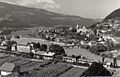
Dravograd 1950


.jpg)

.jpg)
literature
- Olga Moder, Jože Koropec, Jože Curk u. a .: Dravograd 1185–1985, 800 Let. (800 years Drauburg), Dravograd municipality 1985.
Web links
Individual evidence
- ↑ PC-AXIS podatkovni portal. http://pxweb.stat.si/ , accessed on February 21, 2017 .
- ↑ Spremembe naselij 1948–95 (German: change of settlement names 1948–1995). 1996. Database. Ljubljana: Geografski inštitut ZRC SAZU, DZS.
- ↑ Special map of the Austro-Hungarian monarchy 1: 75,000 - Unterdrauburg 5354. (1913)
- ↑ Special map of the Austro-Hungarian monarchy 1: 75,000 - Unterdrauburg 5354. (1913)
- ↑ Population tables of the Statistical Office of the Republic of Slovenia ( Slovene )
- ↑ http://rkd.situla.org ; Ministry of Culture of Slovenia; Register of Immovable Cultural Heritage, No.EŠD: 29280
- ↑ Pavle Blaznik, Slovenska Štajerska in Jugoslovanski del Koroške do leta 1500 (Maribor 1986), p 167
- ↑ http://www.gradovi.net/grad/dravograd_grad
- ↑ http://web.archive.org/web/20170703092158/http://www.mocis.si/files/delightful-downloads/2016/06/Brosura_Gradovi.pdf
- ↑ https://adw-goe.de/en/digital-library/hoefe-und-residenzen-im-spaetmittelalterlichen-reich/gsn/rf15_IV-1608/
- ↑ Certificate number 104 in the archive of St. Paul Abbey
- ↑ Christian Domenig: Tuon kundt. The Counts of Cilli in their documents; S 316; University of Klagenfurt, January 2004
- ↑ Certificate, signature 1375 in the archive of St. Paul Abbey
- ^ Carinthia - Journal of Patriotic Studies, Instruction and Entertainment, No. 7 and 8, Beda Schroll: The Benedictine monastery of St. Paul; S 173; Klagenfurt 1876
- ↑ Mlinarič, Jože: Kartuziji Žiče in Jurklošter ( chartreuse Zice (Seitz village) and Jurk Loster (Gairach) ); Založba Obzorja Maribor. st. 456; 1991. COBISS 29339137. ISBN 86-377-0587-1
- ↑ Source: Historical local dictionary of the Austrian Academy. Statistical documentation on population and settlement history, Carinthia p. 14; Vienna 2016
- ↑ The Kingdom of Illyria according to its latest division; Klagenfurt 1826, p. 53
- ↑ Source: Historical local dictionary of the Austrian Academy. Statistical documentation on population and settlement history, Carinthia p. 14; Vienna 2016
- ↑ KK Statistische Central-Commission, Special-Orts-Repertorien of the kingdoms and countries represented in the Oesterreichischen Reichsrathe. Volume V Carinthia (Vienna 1883) p. 92.
- ^ Gerhard Pilgram, Wilhelm Berger, Gerhard Maurer: Kärnten. Down through - a unique hiking travel book. Universitätskulturzentrum Unikum, Klagenfurt ²1999, pp. 23–26
- ^ Novak, Gregor: Zgodovina dravskih hidroelectrarn med Dravogradom in Mariborom ( history of the Drava hydropower plants between Dravograd and Maribor ); University of Maribor, 2016
- ^ Independent historians' commission on the history of the Reich Labor Ministry 1933-1945, Working Papers Series A No. 8th; Elizabeth Harvey and Kim Christian Priemel. Local dimension of labor input. Mining in the CdZ areas of Lower Styria, Carinthia and Carniola; 2017
- ↑ Spremembe naselij 1948–95 (German: change of settlement names 1948–1995). 1996. Database. Ljubljana: Geografski inštitut ZRC SAZU, DZS.
- ^ History
- ^ Journal of the Historisches Verein für Steiermark, Volume 63, 1972; Frank Leskoschek: Shipping and rafting on the Drava from Unterdrauburg (Dravograd)
- ^ Journal of the Historisches Verein für Steiermark, Volume 63, 1972; Frank Leskoschek: Shipping and rafting on the Drava from Unterdrauburg (Dravograd); P. 140
- ↑ http://rkd.situla.org ; Ministry of Culture of Slovenia; Register of Immovable Cultural Heritage, No. EŠD: 7387
- ↑ http://rkd.situla.org ; Ministry of Culture of Slovenia; Register of Immovable Cultural Heritage, No.EŠD: 126
- ↑ http://rkd.situla.org ; Ministry of Culture of Slovenia; Register of Immovable Cultural Heritage, No.EŠD: 2956
- ↑ http://rkd.situla.org ; Ministry of Culture of Slovenia; Register of Immovable Cultural Heritage, No. EŠD: 7459
- ↑ http://rkd.situla.org ; Ministry of Culture of Slovenia; Register of Immovable Cultural Heritage, No. EŠD: 7384
- ↑ http://rkd.situla.org ; Ministry of Culture of Slovenia; Register of Immovable Cultural Heritage, No. EŠD: 7385; 7400
- ↑ http://rkd.situla.org ; Ministry of Culture of Slovenia; Register of Immovable Cultural Heritage, No. EŠD: 7378
- ↑ http://rkd.situla.org ; Ministry of Culture of Slovenia; Register of Immovable Cultural Heritage, No.EŠD: 3025
- ↑ http://rkd.situla.org ; Ministry of Culture of Slovenia; Register of Immovable Cultural Heritage, No.EŠD: 2958
- ↑ http://rkd.situla.org ; Ministry of Culture of Slovenia; Register of Immovable Cultural Heritage, No.EŠD: 3210
- ↑ http://rkd.situla.org ; Ministry of Culture of Slovenia; Register of Immovable Cultural Heritage, No. EŠD: 3101
- ↑ http://rkd.situla.org ; Ministry of Culture of Slovenia; Register of Immovable Cultural Heritage, No. EŠD: 295
Črna na Koroškem · Dravograd · Mežica · Mislinja · Muta · Podvelka · Prevalje · Radlje ob Dravi · Ravne na Koroškem · Ribnica na Pohorju · Slovenj Gradec · Vuzenica