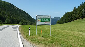
Pielachtaler Gscheid
| Pielachtaler Gscheid | |||
|---|---|---|---|
|
Pass height |
|||
| Compass direction | northwest | Southeast | |
| Pass height | 841 m above sea level A. | ||
| district | Sankt Pölten-Land , Lower Austria | Lilienfeld , Lower Austria | |
| Watershed | Pielach → Danube | Türnitz → Traisen → Danube | |
| Valley locations | Schwarzenbach an der Pielach | Türnitz | |
| profile | |||
| Ø pitch | % (283 m /? Km) | % (175 m /? Km) | |
| Map (Lower Austria) | |||
|
|
|||
| Coordinates | 47 ° 56 '20 " N , 15 ° 25' 38" E | ||
The Pielachtaler Gscheid (also Türnitzer Gscheid ) is 841 m above sea level. A. high mountain pass in southern Lower Austria , which connects the Pielachtal with the Traisental .
Starting from the B 39 Pielachtal Straße , the little-traveled state road L 102 leads to Schwarzenbach an der Pielach and on through the Brunnrotte, where the road climbs up to the top of the pass with up to 12% inclines and, after similar inclines , leads to Türnitz , where it finally leads to the B 20 Mariazeller Straße . On both sides of the pass the road winds in a few switchbacks to reach the less spectacular saddle.
Individual evidence
- ↑ Pielachtaler Gscheid and the surrounding area on ÖK 50 , www.austrianmap.at , Federal Office for Metrology and Surveying Austria, Austrian map, scale 1: 50,000.
- ↑ http://www.quaeldich.de/paesse/tuernitzer-gscheid/

