
Schwarzenbach an der Pielach
|
Schwarzenbach an der Pielach
|
||
|---|---|---|
| coat of arms | Austria map | |
 |
|
|
| Basic data | ||
| Country: | Austria | |
| State : | Lower Austria | |
| Political District : | Sankt Pölten-Land | |
| License plate : | PL | |
| Main town : | Well rot | |
| Surface: | 45.37 km² | |
| Coordinates : | 47 ° 57 ' N , 15 ° 23' E | |
| Height : | 510 m above sea level A. | |
| Residents : | 380 (January 1, 2020) | |
| Postal code : | 3212 | |
| Area code : | 02724 | |
| Community code : | 3 19 39 | |
| NUTS region | AT123 | |
| Address of the municipal administration: |
Brunnrotte 40 3212 Schwarzenbach an der Pielach |
|
| Website: | ||
| politics | ||
| Mayor : | Andreas Ganaus ( ÖVP ) | |
|
Municipal Council : ( 2020 ) (13 members) |
||
| Location of Schwarzenbach an der Pielach in the Sankt Pölten-Land district | ||
  |
||
 View of the town center with the parish hall (second house from the left) and church |
||
| Source: Municipal data from Statistics Austria | ||

Schwarzenbach an der Pielach is a municipality with 380 inhabitants (as of January 1, 2020) in the district of Sankt Pölten-Land in Lower Austria .
geography
Schwarzenbach an der Pielach is located in the Mostviertel in Lower Austria. The area of the municipality covers 45.37 square kilometers, about 82 percent of the area is forested. In Schwarzenbach an der Pielach, on the border with Annaberg, lies the highest mountain in the St. Pölten district, the Hennesteck ( 1334 m ). The second largest cave in Lower Austria, the “Trockene Loch” (dry cave), is located on the Schwarzenbach an der Pielach - Annaberg pilgrimage route; the cave is specially protected.
Community structure
The municipal area includes the following 13 street names that have existed longer than the access roads, hence the names "area", "forest" and "Rotte". The settlement with the street name Obertal was added in the 1980s (population in brackets as of January 1, 2020):
- Brunnrotte (98) including Schwarzenbach an der Pielach
- Finzenebengebiet (1)
- Gravestone Forest (0)
- Guttenhof area (54)
- Haslaurotte (36)
- Hofrotte (34)
- Loicheck area (1)
- Obertal (45)
- Schwarzenbach area (7)
- Sea Rot (42)
- Reservoir area (13)
- Stone rot (20)
- Taschlgrabenrotte (23)
- Weissenbach (6)
The community consists of the only cadastral community Schwarzenbach an der Pielach.
history
In ancient times, the area was part of the Noricum province . Schwarzenbach was first mentioned in a document in the fief book of Albrecht V. 1411.
Population development
On January 1st, 2014 there were 368 inhabitants, according to the results of the 2001 census it was 427. In 1991 the municipality had 450 inhabitants, in 1981 476 and in 1971 511 inhabitants.
Culture and sights
Economy and Infrastructure
In 2001 there were 17 non-agricultural workplaces, according to the 1999 survey there were 46 agricultural and forestry holdings. According to the 2001 census, the number of people in employment in their place of residence was 184, the employment rate in 2001 was 45 percent.
Security and Social
health
The office of the Arbeiter-Samariter-Bund was incorporated into Frankenfels, members from Schwarzenbach are doing their job there, and the area also includes Schwarzenbach.
fire Department
Schwarzenbach an der Pielach has its own volunteer fire brigade. The commandant is fire chief Andreas Ganaus, who has also been the commandant of the Kirchberg an der Pielach fire department section since October 30, 2009.
Ski lift
In the winter, a drag lift was operated in Schwarzenbach an der Pielach until 2009 (Schilift Enne). The lift was located southwest of the village not far from the Haslaurotte. The slopes are exposed to the northeast, there were no artificial snow-making systems.
Sports
There is the Schwarzenbach sports club, founded in 1978, and the Schwarzenbach Active Club, which also organizes sporting activities. Together with the neighboring community of Frankenfels , the FCU Frankenfels / Schwarzenbach plays in 2nd class in the foothills of the Alps.
traffic
Railroad and bus
The Mariazellerbahn does not run through the municipality of Schwarzenbach, but there is still a Schwarzenbach an der Pielach train station 6 km away in the municipality of Frankenfels .
Up until the beginning of the 2000s there was a regular bus connection from Schwarzenbach train station (in some timetable periods from Frankenfels train station) to the town once or twice a working day (more often on school days). This bus connection was discontinued and since then Schwarzenbach can only be reached by private car.
Street
Schwarzenbach is located on a state road L 102, which leads from Pielachtal Straße B 39 via Schwarzenbach an der Pielach and the Pielachtaler Gscheid to Türnitz , where it joins Mariazeller Straße B 20.
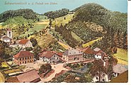
Schwarzenbach an der Pielach, around 1912

Steinberg lift from the valley station

The Schwarzenbach an der Pielach train station in the municipality of Frankenfels, which was demolished on March 11, 2015 and replaced by a glass bus shelter opposite


Web links
- 31939 - Schwarzenbach an der Pielach. Community data, Statistics Austria .
- www.schwarzenbach-pielach.gv.at community website of Schwarzenbach an der Pielach
Individual evidence
- ↑ Statistics Austria: Population on January 1st, 2020 by locality (area status on January 1st, 2020) , ( CSV )
- ^ Report of the St. Pölten District Fire Brigade Command, accessed on November 3, 2009

Altlengbach | Asperhofen | Böheimkirchen | Brand-Laaben | Eichgraben | Frankenfels | Gablitz | Gerersdorf | Hafnerbach | Haunoldstein | Herzogenburg | Hofstetten-Grünau | Inzersdorf-Getzersdorf | Kapelln | Karlstetten | Box near Böheimkirchen | Kirchberg an der Pielach | Kirchstetten | Loich | Maria-Anzbach | Markersdorf-Haindorf | Mauerbach | Michelbach | Envious | Neulengbach | Neustift-Innermanzing | Nussdorf ob der Traisen | Ober-Grafendorf | Obritzberg-Rust | Perschling | Press tree | Prinzersdorf | Purkersdorf | Pyhra | Rabenstein an der Pielach | Schwarzenbach an der Pielach | St. Margarethen an der Sierning | Statzendorf | Stössing | Traismauer | Tullnerbach | Weinburg | Wilhelmsburg | Wölbling | Wolf pit
Cadastral communities: Schwarzenbach
Locations: Brunnrotte | Finzenebengebiet | Gravestone Forest | Guttenhof area | Haslaurotte | Hofrotte | Loicheck area | Schwarzenbach area | Sea rott | Reservoir area | Stone rot | Taschlgrabenrotte
Village: Schwarzenbach an der Pielach Scattered houses: Brunnrotte | Finzenebengebiet | Guttenhof area | Haslaurotte | Hofrotte | Schwarzenbach area | Sea rott | Reservoir area | Stone rot | Taschlgrabenrotte
Counting district: Schwarzenbach an der Pielach