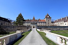
Inzersdorf-Getzersdorf
|
Inzersdorf-Getzersdorf
|
||
|---|---|---|
| coat of arms | Austria map | |
|
|
||
| Basic data | ||
| Country: | Austria | |
| State : | Lower Austria | |
| Political District : | Sankt Pölten-Land | |
| License plate : | PL | |
| Main town : | Inzersdorf ob der Traisen | |
| Surface: | 13.57 km² | |
| Coordinates : | 48 ° 19 ′ N , 15 ° 40 ′ E | |
| Height : | 260 m above sea level A. | |
| Residents : | 1,617 (January 1, 2020) | |
| Population density : | 119 inhabitants per km² | |
| Postcodes : | 3130 and 3131 | |
| Area code : | 02782 | |
| Community code : | 3 19 13 | |
| NUTS region | AT123 | |
| Address of the municipal administration: |
Dorfstrasse 20 3131 Inzersdorf |
|
| Website: | ||
| politics | ||
| Mayor : | Ewald Gorth ( ÖVP ) | |
|
Municipal Council : ( 2020 ) (19 members) |
||
| Location of Inzersdorf-Getzersdorf in the Sankt Pölten-Land district | ||
| Source: Municipal data from Statistics Austria | ||
Inzersdorf-Getzersdorf is a municipality with 1617 inhabitants (as of January 1, 2020) in the district of Sankt Pölten-Land in Lower Austria .
geography
Inzersdorf-Getzersdorf is located in the Mostviertel in Lower Austria. The area of the municipality covers 13.72 square kilometers. 8.45 percent of the area is forested.
Community structure
The municipality includes the following five localities (population in brackets as of January 1, 2020):
- Anzenberg (73)
- Getzersdorf (527) including the station settlement
- Inzersdorf ob der Traisen (506)
- Walpersdorf (410)
- Wetzmannsthal (101)
The community consists of the cadastral communities Anzenberg, Getzersdorf, Inzersdorf an der Traisen, Walpersdorf and Wetzmannsthal.
history
In ancient times, the area was part of the Celtic kingdom of Noricum and later the Roman province of the same name.
In 1850, independent communities were formed in Inzersdorf and Getzersdorf. The Getzersdorf municipality, which was only independent until 1863, was merged with Inzersdorf and only became a separate municipality again in 1919. In 1970 the councils of Inzersdorf and Getzersdorf decided to merge the two communities under the name Inzersdorf-Getzersdorf.
Population development
According to the results of the 2001 census, there were 1399 inhabitants. In 1991 the municipality had 1,335 inhabitants, in 1981 1,133 and in 1971 1,143 inhabitants.
Archaeological sites
Getzersdorf
When gravel mining was carried out in the "railway gravel pit next to the Getzersdorf station", some graves from the Latène period were uncovered from 1899 to 1923 . There were a total of 13 body burials, including a double grave, which can be dated from the Early to the Middle Ages. The archaeologists found a choker ( torques ) with seal-like ends and plastic ornamentation as well as some richly decorated bracelets among grave goods . The graves belong to a group of such objects that extend in the hinterland of the Traisen on a river terrace.
Inzersdorf
A group of graves with body burials, a cremation and round or square borders were discovered here. Ceramic goods , some fine pottery wheels, some coarser hand-made objects, as well as brooches , belt hooks, lance tips, knife and shield humps allowed the dating to the early La Tène period. Some of the bone finds showed signs of polio, others of skull fractures.
Walpersdorf
A settlement from the late Hallstatt to Latène period on the left bank of the Traisen, also located on a river terrace, is the most extensive site in this area. The buildings were partly sunk, partly erected in post-and-beam construction. Beautifully worked and polished pottery wheel ceramics from the late Hallstatt period , a gold-decorated crucible , animal and human bone finds deposited in pits - including a skull with traces of trepanation - point to an agrarian manor house.
In the northwest of the group of buildings, an extensive burial ground was found using aerial archeology . A group of graves uncovered in 1987 revealed eleven bodies and one cremation. Two women, eight men and three young people with additions of ceramics, belt hooks, rings, brooches and the amber handle of a nail cleaner were discovered. Another group of graves west of it resulted in a total of 34 grave sites (18 body and 16 cremation burials) with similar finds.
politics
Ewald Gorth has been the mayor of the municipality since November 18, 2014. After the 2020 municipal council elections , there will be 19 seats in the municipal council as follows: ÖVP 14, SPÖ 4, FPÖ 1, others no seats.
Culture and sights
Economy and Infrastructure
In 2001 there were 45 non-agricultural workplaces, and according to the 1999 survey there were 74 in agriculture and forestry. The number of people in work at home was 636 according to the 2001 census. The 2001 employment rate was 46.53 percent.
Web links
- Municipality of Inzersdorf-Getzersdorf Homepage of the municipality
- 31913 - Inzersdorf-Getzersdorf. Community data, Statistics Austria .
Individual evidence
- ↑ Statistics Austria: Population on January 1st, 2020 by locality (area status on January 1st, 2020) , ( CSV )
- ^ Susanne Sievers / Otto Helmut Urban / Peter C. Ramsl: Lexicon for Celtic Archeology. A-K and L-Z ; Announcements of the prehistoric commission published by the Austrian Academy of Sciences , Vienna 2012, ISBN 978-3-7001-6765-5 , p. 635.
- ↑ a b Sievers / Urban / Ramsl: Lexicon of Celtic Archeology. A-K and L-Z ; P. 832 f.
- ↑ Results of the municipal council election 2020 in Inzersdorf-Getzersdorf. Office of the Lower Austrian State Government, January 26, 2020, accessed on February 25, 2020 .


