
Frankenfels
|
market community Frankenfels
|
||
|---|---|---|
| coat of arms | Austria map | |
 |
|
|
| Basic data | ||
| Country: | Austria | |
| State : | Lower Austria | |
| Political District : | Sankt Pölten-Land | |
| License plate : | PL | |
| Surface: | 56.16 km² | |
| Coordinates : | 47 ° 59 ' N , 15 ° 20' E | |
| Height : | 464 m above sea level A. | |
| Residents : | 1,941 (January 1, 2020) | |
| Population density : | 35 inhabitants per km² | |
| Postal code : | 3213 | |
| Area code : | 02725 | |
| Community code : | 3 19 06 | |
| NUTS region | AT123 | |
| Address of the municipal administration: |
Markt 10 3213 Frankenfels |
|
| Website: | ||
| politics | ||
| Mayor : | Heinrich Putzenlechner ( ÖVP ) | |
|
Municipal Council : ( 2020 ) (21 members) |
||
| Location of Frankenfels in the district of Sankt Pölten-Land | ||
  |
||
| Source: Municipal data from Statistics Austria | ||

Frankenfels is a market town with 1941 inhabitants (as of January 1, 2020) in the district of Sankt Pölten-Land in Lower Austria .
geography
The market town is located in the Mostviertel in Lower Austria, in the Pielach Valley . The area of the market town covers 56.11 square kilometers, on the Pielach itself, on the Nattersbach and on the Weißenbach , two of its left tributaries.
57.34 percent of the area is forested.
Community structure
The municipality includes 2020 following 19 localities: Falkenstein rotting together Redtenbach, Fischbachmühlrotte, Franken Rock, Grasser rotting, Gstettengegend, Hofstadtgegend, carrot , Laubbach area Lehen area, brand impact rotting, Ödrotte, Pernarotte, Pielachleitengegend, Rosenbühelrotte, Taschlgrabenrotte, low grave rotting , transition rotting, Weissenburg area including Weissenburg and meadow rotting . As of 2020, the community will only consist of one village.
The community consists only of the cadastral community of Frankenfels.
Counting districts are Frankenfels central area (Frankenfels, parts of Hofstadt area, Lehen area and Rosenbühelrotte) and Frankenfels area (rest of the community).
Neighboring communities
history

In the 11th century Bavarian settlers made the land under the Enns arable. The settlement of the area around Frankenfels and the urbanization of the Upper Pielach Valley also fell during this period . Back then, the Bavarian colonial rulers occasionally met Slavic settlers , local names such as Gillus, Zigga, Perna and others confirm this thesis.
Around 1300 Konrad Sommerauer von Wallsee sold land to Archduke Albrecht as the land around Franchenvels , today's Frankenfels. Are already in this document, many place names that still exists in the cadastral plan are noted detained. A large part of the farms still in operation today were first mentioned in the Wallsee land register from 1449. The division of the region into Rotten has existed since 1629.
In 1596/97 the Puchenstuben host Christian Haller also gathered many farmers from Frankenfels to fight against the imperial family . The uprising, triggered by the unbearable tax burden, was put down after heavy fighting. Many had to lose their lives.
In the 16th and 17th centuries, Frankenfels gained economic and social importance , mainly through the work of the Tattenbach family from Weißenburg . The granting of market rights to Frankenfels in 1655 crowned this endeavor. Around 1630, the division into the division of the groups and areas, which is still in use today, followed. The house numbering and the first plans for the cadastral map (Josefinic cadastre - named after Josef II ) were created between 1770 and 1787.
With the opening of the second section of the Mariazellerbahn , Frankenfels was connected to the railway network.
In 2015, Frankenfels was one of the main venues for the Lower Austrian provincial exhibition under the title ÖTSCHER: REICH - The Alps and Us .
Population development
After a strong increase in population in the second half of the 20th century, the number of inhabitants has decreased slightly since 2000.

politics
_Town_hall_in_Frankenfels.jpg)
Community representation
In the municipal council there are a total of 21 seats after the municipal council election on January 26th, 2020
- 15 mandates of the Austrian People's Party (ÖVP)
- 5 mandates of the Social Democratic Party of Austria (SPÖ)
- 1 Mandates for the Freedom Party of Austria (FPÖ)
Mayor of the market town is Heinrich Putzenlechner (ÖVP).
mayor
_Grave_of_family_P%C3%B6gner_at_cemetery_Frankenfels.jpg)
- Josef Pögner (1830–1899), innkeeper at the Neuhaus , shopkeeper (dealer) , travel agent ( postmaster) and founder of the fire service, 1867–1889
- Franz Fahrngruber, landlord in the Schmeisselmühle , 1889–1990
- Josef Fahrnberger, landlord at Fuchsstein , 1890–1891
- Josef Schafhuber, innkeeper in the tavern am Steg , approx. 1891–1900
- Anton Pögner (1871–1926), innkeeper at Neuhaus and merchant, approx. 1901–1906
- Leopold Wieder (* 1859), landlord and mill owner in the Schmeisselmühle , approx. 1906–1918
- Josef Schagerl (* 1868), business owner in the Pielachleiten , 1918–1929
- Josef Niederer, business owner, 1929–1938
- Leopold Friewald (* 1897), teacher, 1938
- Franz Labner (1894–1984), estate manager, 1938–1945
- Josef Niederer, business owner, 1945
- Franz Winter, business owner, 1945–1946
- Josef Niederer, business owner, 1946–1956
- Alois Fahrnberger (1895–1966), owner of the Fuchsstein farm , 1956–1965
- Franz Großerbacher (1916–1999), community secretary, 1965–1987
- Friedrich Griesauer (* 1938), business owner at Hinter-Hehenberg , 1987–1999
- Ernst Langthaler (* 1941), employee, 1999–2009
- Franz Großerbacher (* 1957), community secretary, 2009–2019
- Heinrich Putzenlechner (* 1958), farmer, from 2019
Town twinning
Frankenfels is a partner municipality of Hollstadt in Lower Franconia .
Capital of the municipality
|
Frankenfels ( capital of a market town ) locality area / Rotte |
|
|---|---|
| Basic data | |
| Pole. District , state | Sankt Pölten-Land , Lower Austria |
| Pole. local community | Frankenfels ( KG Frankenfels ) |
| Coordinates | 47 ° 58 ′ 55 ″ N , 15 ° 19 ′ 31 ″ E |
| height | 464 m above sea level A. |
| Residents of the village | 1941 (January 1, 2020) |
| Building status | 120 (2001) |
| Statistical identification | |
| Locality code | 05435 |
| Counting district / district | Frankenfels Central Area (31906 000) |
| Source: STAT : index of places ; BEV : GEONAM ; NÖGIS | |
The community capital as well as the village is the market town of Frankenfels . It is located about 32 kilometers as the crow flies southwest of St. Pölten. It is located in the middle of the municipality, at about 460 m above sea level. A. Höhe in the valley of the Nattersbach , the left (western) tributary of the Pielach near the Pielach area , and extends for a little more than a kilometer downstream and up the church .
The village has around 120 buildings with around 460 inhabitants, that's a good 1 ⁄ 5 of the community's population.
Almost the entire Hofstadt area out of the valley, a few houses close to the fiefs and most of the Rosenbühelrotte in the valley belong to the counting district Frankenfels-Zentralgebiet . This includes around 230 buildings with around 900 inhabitants ( 2 ⁄ 5 of the community population) and corresponds to the valley settlement area on the lower Nattersbach.
The valley runs through the local area along Pielachtal Straße (B39) and Mariazellerbahn , the village is connected by the Frankenfels stop .
- Neighboring towns and cities
| Leaning area (O) | Hofstadtgebiet (O) | |
| Rosenbühelrotte (O) |
.svg)
|
Falkensteinrotte (O) |
|
Brand grotto (O)
|
stone
Grass rotting (O) |
Stein, classified by Statistics Austria as scattered houses, describes the objects Unter-Stein, Mitter-Stein and Ober-Stein , which are known locally as Stein -häuser. The courtyards were called Super Lapide in Latin in 1300 and were not divided up until a few centuries later.
Economy and Infrastructure
In 2001 there were 71 non-agricultural workplaces, and there were 162 agricultural and forestry holdings according to the 1999 survey. The number of people in employment at home was 1,019 according to the 2001 census. The employment rate in 2001 was 47.87 percent.
traffic

- railroad
Frankenfels is located on the Mariazellerbahn . This railway line stops in the municipality at the Schwarzenbach an der Pielach stops in Hofstadtgebiet , Frankenfels , at the Laubenbachmühle depot and at the Boding near Pernarotte stop . The Weißenburg and Unterbuchberg stops were closed, the former as early as the mid-1920s, the latter in 2010. The route is led through several tunnels and bridges in the Frankenfels municipality.

Schwarzenbach an der Pielach stop

Frankenfels train station

Boding stop

Laubenbachmühle station
.jpg)


- Street
Frankenfels is connected to the higher-ranking road network by the B39 ( Pielachtal Straße ) . In addition, major national roads lead via Weißenburg and Plankenstein to Texing , as well as via Schwarzenbach an der Pielach and the Pielachtaler Gscheid to Türnitz . There are also connections to Schlagerboden and St. Gotthard . There are also 101 km of freight routes , most of which are managed by freight road communities (as of March 2018).
Security and Social
- health
Frankenfels has a general practitioner with his own medicine cabinet and a specialist in dentistry and maxillofacial medicine.
Since 1961 there has also been a local office of the Arbeiter-Samariter-Bund , which was largely founded by members of the SPÖ Frankenfels. There are three rescue vehicles in use for the population of Frankenfels and the immediate vicinity (as of 2018), with the fleet last being supplemented in 2017 with a new rescue transport vehicle. Around 50 paramedics are active for the Frankenfels rescue center and there are almost 300 supporting members. In addition, two to five people doing community service are always involved in rescue and ambulance transport.
There is also Volkshilfe and Meals on Wheels in Frankenfels.
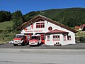
- fire Department
The Frankenfels volunteer fire brigade has existed in Frankenfels since 1883 . The founder and first fire chief was Mayor Josef Pögner. Due to the large community area and the exposed location of the mainly agricultural objects, the Weißenburg branch was established in the Weißenburg area on January 1, 1938, which initially had the strength of a group and was later a separate train from January 1, 1970. From this unit, which was later stationed in the Tiefgrabenrotte and from 1986 referred to as the Weißenburg fire station, the newly founded Weissenburg volunteer fire station emerged on May 7, 2017.
There is also a disaster control camp in the Hofstadt area.
On November 21, 1992, the youth fire department was founded in Frankenfels and presented at the annual general meeting in 1993.
_Painting_from_Josef_Z%C3%B6chling_at_fire_station_and_museum_in_Frankenfels.jpg)
In 2008, a museum was built on the initiative of Erich Gonaus, head of the administrative service of the Frankenfels volunteer fire brigade, which was opened in 2009. The following exhibits are currently on display:
- Founder syringe (Hydrophor) (1883)
- Hook ladder (1883)
- Large hydrophor on horse-drawn cart (1898)
- Wooden winch (around 1900)
- Stretcher (1928)
- Fire engine motorcycle (1955)
- Land Rover with portable pump trailer (1957)
- Rescue case (1945)
- Five portable pumps
- Linen, leather and fire buckets
- Communication devices
- Clothing
- Orders, decorations and badges
Thomas Wutzl is the commander of the Frankenfels volunteer fire brigade, Günter Tuder is the commander of the Weißenburg volunteer fire brigade.

ASBÖ Frankenfels and Raiffeisenbank, behind the Falkenstein wall (2018)

Founding photo of the Frankenfels volunteer fire brigade (1883)

The fire station of the Frankenfels volunteer fire brigade is currently being demolished and will be rebuilt in 2020.
Fire station of the volunteer fire brigade Weißenburg in the Tiefgrabenrotte , which was renovated and expanded from 2009 to 2012 on the basis of the fire station built in 1980 (2012)

Interior view of the Fire Brigade Museum in Frankenfels (2017)
_ASB%C3%96_Frankenfels,_Raiffeisenbank_and_behind_the_Falkensteinmauer.jpg)

_Feuerwehrhaus_Frankenfels,_Austria.jpg)

_Feuerwehrmuseum_Frankenfels.jpg)
Culture and sights
Buildings

Interesting buildings are the Castle White Castle , the Schwabeck Cross (actually already on Texinger area ) that Grasser mill that Anna Cross , and other chapels and the parish church Frankenfels . The station and operations base of the Mariazellerbahn, the Laubenbachmühle station, was rebuilt .

The Schwabeck Cross

The Anna cross

.jpg)
Natural attractions
_Falkensteinmauer_in_Frankenfels,_Austria.jpg)
In Frankenfels there are natural attractions, the Nix cave, developed as a show cave, the dominant Falkenstein wall and the Taubenbach gorge .

The Nix cave

Tourism and leisure facilities
_Bahnhof_Frankenfels.jpg)
- Bergbauernmuseum Hausstein
- Mariazellerbahn
- Frankenfelser tree circle
- Hotel complex Steinschaler Dörfl
In addition to marked walking and hiking trails, the following open-air activities are offered in Frankenfels: The climbing gardens at the up to 80 m high Falkenstein wall, at Schrambach, Gillus and Anglbach; Nature trails; Mountain bike trails; Natural toboggan runs; Frankenfels outdoor pool; Beach volleyball court; Game reserve. There are also some businesses that offer farm holidays .
Cultural life

As in many other municipalities in the region, cultural life is strongly influenced by the activity of local associations and organizations.
- Trachtenmusikverein Frankenfels, emerged from the Hölzl chapel in 1924 and founded in 1959.
- Music association Ötscherland
- The rural youth Frankenfels regularly organizes the so-called farmer's theater in Franconian restaurants.
Regular events
Every year there are balls, Wednesday events with regional culinary specialties and tent parties of the clubs and local organizations (e.g. the fire brigade festivals). There are also regular pilgrimages on foot to Mariazell (via Schwarzenbach an der Pielach ) and to St. Gotthard via the Schwabeck cross at Tiefgrabenrotte in Weißenbach.
Every five years, Frankenfels is also the scene of the 'Pielachtalter Dirndlkirtag', a major regional event that takes place annually alternately in another village in the Pielach Valley. Most recently, the Frankenfelser Dirndlkirtag 2017 took place, where the official number of visitors was 15,800 according to the organizer and the municipality.
Sports
The Union Raika Frankenfels football club, founded in 1980, is entitled to play with the fighting team in the 2nd class of the Alpine Foreland. In addition, the FCU currently names five youth teams from U9 to U16.
The Frankenfels shooting club , founded in 1965, plays in the national league. In addition, several other sports activities, such as B. winter sports, organized in associations and clubs.
There is a ski lift in the Hofstadt area. Since December 2011 there has been a fan club in Frankenfels for ÖSV professional Marc Digruber , who lives in Fischbachgraben in Frankenfels.
Personalities
- sorted by date of birth:
- Josepha Werndl (1806–1867), wife of Leopold Werndl and mother of the arms manufacturer Josef Werndl
- Johannes Fahrngruber (1845–1901), theology professor, local researcher, art historian and founder of the St. Pölten Diocesan Museum
- Siegfried Stockmayer (1868–1933), physician, botanist and community doctor from Frankenfels
- Hugo Jury (1887–1945), community doctor and later a National Socialist politician
- Franz Niederer (1903–1948), musician, founder of several music groups and victim of a rampage
- Josef Stangl (1911–1966), pastor and resistance fighter
- Franz Großbacher (1916–1999), mayor, fire brigade commander and district chairman of the Lower Austrian brass band
- Anton Wicho (1924–1960), ski racer
- Anton Gollubitsch (1928–1980), skibob senior world champion from 1971
- Franz Niederer (1929–2019), musician and professor
- Bernhard Gamsjäger (* 1949), author of several books on local and regional history, winner of the Theodor Körner Prize in 1983 and winner of the Lower Austrian Culture Prize in 1989 and 2010.
- Ernst Langthaler (* 1965), historian, university professor, winner of the Lower Austrian Culture Prize in 2004 and 2005
- Martin Neubauer (* 1973), chess player and trainer
- Norbert Prammer (* 1982), actor
- Josef Kugler (* 1984), cyclist
- Christian Schagerl (* 1986), cook
- Marc Digruber (* 1988), ski racer
- Sascha Fahrngruber (* 1989), soccer player in the first division ( SKN St. Pölten , SKU Amstetten and SK Vorwärts Steyr )
literature
- Bernhard Gamsjäger : Frankenfelser Häuserbuch , Frankenfels 1987.
- Bernhard Gamsjäger and Ernst Langthaler (eds.): Das Frankenfelser Buch , Frankenfels 1997.
- Franz Xaver Schweickhardt : Depiction of the Archduchy of Austria under the Ens, district of Upper Vienna Woods (today around Mostviertel) . Volume 7: Schwerbach area (Kirchberg rulership) to Weissenbach . Vienna 1837 ( online version ).
Web links
- Marktgemeinde Frankenfels Homepage of the municipality
- Entry on Frankenfels in the Austria Forum (in the AEIOU Austria Lexicon )
- 31906 - Frankenfels. Community data, Statistics Austria .
Individual evidence
- ↑ Klein : Historical local dictionary . Ed .: VID. Lower Austria part 3, carrot , p. 82 ( online document - oD [update]).
- ^ Statistics Austria, A look at the community of Frankenfels, population development. Retrieved February 7, 2019 .
- ↑ Bernhard Gamsjäger, Ernst Langthaler (Ed.): The Frankenfelser book . Frankenfels 1997, p. 378 etc.
- ^ Bernhard Gamsjäger: Frankenfelser Häuserbuch , Frankenfels 1987, page 85
- ^ ASBÖ Frankenfels: Group: fleet, active and members. 2018, accessed March 14, 2018 .
- ↑ Frankenfels volunteer fire brigade: Annual report 2010
- ^ Website of the Frankenfels Trachtenmusikverein ( Memento from November 9, 2011 in the Internet Archive ), accessed on June 30, 2010.
- ↑ Dirndlkirtag in the Dirndlwiki. Retrieved March 15, 2018 .
- ↑ Stefanie Fahrngruber: Frankenfels - Annual Review and Dirndlkirtag Review. In: www.frankenfels.at. Marktgemeinde Frankenfels, December 20, 2017, accessed on March 15, 2018 .
- ^ Bernhard Gamsjäger and Ernst Langthaler (eds.): The Frankenfelser book . Frankenfels 1997, p. 264.

Altlengbach | Asperhofen | Böheimkirchen | Brand-Laaben | Eichgraben | Frankenfels | Gablitz | Gerersdorf | Hafnerbach | Haunoldstein | Herzogenburg | Hofstetten-Grünau | Inzersdorf-Getzersdorf | Kapelln | Karlstetten | Box near Böheimkirchen | Kirchberg an der Pielach | Kirchstetten | Loich | Maria-Anzbach | Markersdorf-Haindorf | Mauerbach | Michelbach | Envious | Neulengbach | Neustift-Innermanzing | Nussdorf ob der Traisen | Ober-Grafendorf | Obritzberg-Rust | Perschling | Press tree | Prinzersdorf | Purkersdorf | Pyhra | Rabenstein an der Pielach | Schwarzenbach an der Pielach | St. Margarethen an der Sierning | Statzendorf | Stössing | Traismauer | Tullnerbach | Weinburg | Wilhelmsburg | Wölbling | Wolf pit
Cadastral communities: Frankenfels
Localities (subdivision: regions and rotten ) *:
Falkensteinrotte |
Fischbachmühlrotte |
Frankenfels |
Grass rotting |
Gstetten area |
Hofstadtgebiet |
Carrot |
Laubenbach area |
Feudal area |
Brand grotto |
Ödrotte |
Pernarrot |
Pielachleiten area |
Rosenbühelrotte |
Taschlgrabenrotte |
Tiefgrabenrotte |
Transition rot * |
Weißenburg area |
Wiesrotte
* not mentioned in the community structure
Market place: Frankenfels | Rotten: Hofstadt area • Rosenbühelrotte • Weißenburg | Scattered houses: Falkenstein rotting • Fischbachmühlrotte • Grasser rotting • Gstettengegend • carrot • Laubbach area • fief area • brand impact rotting • Ödrotte • Pernarotte • Pielachleitengegend • Redtenbach • Stone • Taschlgrabenrotte • Deep grave rotting • transition rotting • White Castle area • Meadow Rottenberg | Other locations: Grassermühle • Weissenburg ruins
Counting district: Frankenfels central area | Frankenfels area

| Previous station |
Mariazellerbahn R8 |
Next station |
|---|---|---|
| Schwarzenbach a. d. Pielach Hst. | Frankenfels Hst. | Boding Hst. |