
Altlengbach
|
market community Altlengbach
|
||
|---|---|---|
| coat of arms | Austria map | |
 |
|
|
| Basic data | ||
| Country: | Austria | |
| State : | Lower Austria | |
| Political District : | Sankt Pölten-Land | |
| License plate : | PL | |
| Surface: | 35.54 km² | |
| Coordinates : | 48 ° 9 ' N , 15 ° 55' E | |
| Height : | 302 m above sea level A. | |
| Residents : | 3,025 (January 1, 2020) | |
| Population density : | 85 inhabitants per km² | |
| Postal code : | 3033 | |
| Area code : | 02774 | |
| Community code : | 3 19 01 | |
| NUTS region | AT123 | |
| Address of the municipal administration: |
Altlengbach 93 3033 Altlengbach |
|
| Website: | ||
| politics | ||
| Mayor : | Michael Göschelbauer ( ÖVP ) | |
|
Municipal Council : ( 2020 ) (21 members) |
||
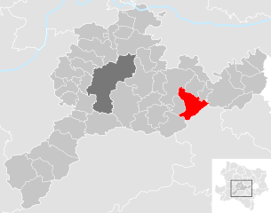
| Location of Altlengbach in the Sankt Pölten-Land district | ||
  |
||
| Source: Municipal data from Statistics Austria | ||


Altlengbach is a market town with 3025 inhabitants (as of January 1, 2020) in the district of Sankt Pölten-Land in Lower Austria .
geography
Altlengbach is located in the Mostviertel in Lower Austria. The area of the market town covers 35.58 square kilometers. 48.94 percent of the area is forested.
Altlengbach is a member of the Wienerwald Initiative Region .
Community structure
The municipality includes the following 26 localities (population in brackets as of January 1, 2020):
- Altlengbach (1016) including Prinzbach
- Audorf (47)
- Ausserfurth (119) including the Reitermühle
- Gottleitsberg (13)
- Grossenberg (21)
- Gschaid (69)
- Haagen (10)
- Hard (74)
- Hocheichberg (65)
- Höfer (8)
- Innerfurth (53)
- Kienberg (26)
- Kleinberg (13)
- Kogl (25)
- Leitsberg (107)
- Lengbachl (210) including Lengbachl-Klara Höhe
- Linden (72)
- Maiß (209) with Kaltenberg and Steineckl
- Manzing (9)
- Nest (13)
- Wasteland (11)
- Ödengraben (30)
- Pamet (5)
- Schoderleh (73)
- Stone House (528)
- Unterthurm (199)
The community consists of the cadastral community Altlengbach.
history
In ancient times, the area was part of the Noricum province .
Altlengbach was mentioned in a document around 1150 as a Kirchweiler.
In 1529 Altlengbach, Prinzbach, Gschaid, Pamet, Windpichl and Hart were destroyed by the Turks during the siege of Vienna ; the fire sites are mentioned in the Altlengbach parish record . On 15./16. In September 1590, Altlengbach was shaken by an earthquake, destroying the village of Unterthurm and causing severe damage to Thurm Castle.
Until the abolition of the basic rule in 1848 Altlengbach seat was a separate rule. The local congregation was formed in 1850. In 1980 the local community Altlengbach was raised to a market community.
Population development
According to the results of the 2011 census, there were 2725 inhabitants, in 2001 there were 2791 inhabitants. In 1991 the market town had 2670 inhabitants, in 1981 2108 and in 1971 1828 inhabitants. The increase in population is explained on the one hand by the brisk construction activity of non-profit cooperatives, as well as by the arrival of townspeople who want to live in the country.
politics
The municipal council has a total of 21 seats. The municipal council election on January 26, 2020 resulted in the following distribution of mandates: ÖVP 13, SPÖ 7, FPÖ 1.
- mayor
- 2003–2015 Wolfgang Luftensteiner (SPÖ)
- since 2015 Michael Göschelbauer (ÖVP)
Culture and sights
- Parish church Altlengbach : The church is part of a castle-church complex. The nave has three naves and three bays. The area of the central nave has a Romanesque origin, the extension by adding the side aisles is likely to have taken place in the 14th century. The elevated choir with a 5/8 end and stepped buttresses dates from the 13th century.
economy
In 2001 there were 113 non-agricultural workplaces, agricultural and forestry operations 108 according to the 1999 survey. According to the 2001 census, the number of people in employment at home was 1329. The employment rate was 48.9 percent in 2001 and 53.2 percent in 2011. The advantages of Altlengbach as a business location, such as the optimal connection to the motorway and the attractive property prices, have recently been recognized again, which has resulted in an above-average number of businesses in the region.
Personalities
- Honorary citizen of the community
- Michael Häupl (* 1949 in Altlengbach), former mayor and governor of Vienna
- People related to the community
- The popular actress Sissy Löwinger settled in the village.
- The comedian Götz Kauffmann spent his childhood in Altlengbach.
- The composer Erwin Trojan lived in Altlengbach from 1933 until his death in 1957.
Web links
- Marktgemeinde Altlengbach Homepage of the municipality
- 31901 - Altlengbach. Community data, Statistics Austria .
Individual evidence
- ↑ Statistics Austria: Population on January 1st, 2020 by locality (area status on January 1st, 2020) , ( CSV )
- ^ History of Altlengbach
- ^ Sackmauer Ludwig : Altlengbacher Chronik, Volume 1 of 2; 1981/84; Self-published
- ↑ Bundesdenkmalamt (Ed.): Dehio-Handbuch. The art monuments of Austria. Lower Austria, south of the Danube , part 1, page 34f., Berger publishing house, Horn / Vienna 2003, ISBN 3-85028-364-X

Altlengbach | Asperhofen | Böheimkirchen | Brand-Laaben | Eichgraben | Frankenfels | Gablitz | Gerersdorf | Hafnerbach | Haunoldstein | Herzogenburg | Hofstetten-Grünau | Inzersdorf-Getzersdorf | Kapelln | Karlstetten | Box near Böheimkirchen | Kirchberg an der Pielach | Kirchstetten | Loich | Maria-Anzbach | Markersdorf-Haindorf | Mauerbach | Michelbach | Envious | Neulengbach | Neustift-Innermanzing | Nussdorf ob der Traisen | Ober-Grafendorf | Obritzberg-Rust | Perschling | Press tree | Prinzersdorf | Purkersdorf | Pyhra | Rabenstein an der Pielach | Schwarzenbach an der Pielach | St. Margarethen an der Sierning | Statzendorf | Stössing | Traismauer | Tullnerbach | Weinburg | Wilhelmsburg | Wölbling | Wolf pit
Cadastral municipality: Altlengbach
Locations: Altlengbach | Audorf | Ausserfurth | Gottleitsberg | Grossenberg | Gschaid | Haagen | Hard | Hocheichberg | Höfer | Innerfurth | Kienberg | Kleinberg | Kogl | Leitsberg | Lengbachl | Linden | Mayß | Manzing | Nest | Wasteland | Ödengraben | Pamet | Schoderleh | Steinhäusl | Unterthurm
Market place: Altlengbach Villages: Leitsberg • Linden • Steinhäusl • Unterthurm Settlement: Lengbachl-Klara Höhe Weiler: Gottleitsberg • Haagen • Höfer • Kaltenberg • Reitermühle • Öd • Pamet Rotten: Audorf • Ausserfurth • Großenberg • Gschaid • Hart • Hocheichberg • Innerfurth • Kienberg • Kogl • Lengbachl • Manzing • Nest • Ödengraben • Prinzbach • Schoderleh • Steineckl Scattered houses: Kleinberg • Maiß Other locations: Tannenmühle Castle
Counting district: Altlengbach central area | Altlengbach area