Hennesteck
| Hennesteck | ||
|---|---|---|
|
Summit with alp from the west |
||
| height | 1334 m above sea level A. | |
| location | Lower Austria , Austria | |
| Mountains | Türnitz Alps | |
| Dominance | 4.1 km → Ahornberg | |
| Notch height | 409 m ↓ Am Reidl | |
| Coordinates | 47 ° 53 '33 " N , 15 ° 21' 36" E | |
|
|
||
| rock | Gutenstein lime | |
| Age of the rock | Anisium | |
|
Summit cross |
||
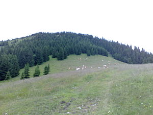
The Hennesteck is a 1334 m above sea level. A. high mountain in the western Türnitz Alps in Lower Austria . It forms an elongated ridge that runs roughly in a south-west-north-east direction.
Environment, name and geology
The flanks of the Hennesteck are predominantly wooded and interspersed with some rock faces. The most comfortable ascent path leads up the relatively gentle south-west flank via Almböden , but there are steep slopes in the north and south-east . Here are cliff-like, diversely layered rock fragments, one of which can be admired directly west of the summit (with a beautiful little wooden cross ). The Mitterkeil ( 1248 m ), which is geomorphologically similar to the Hennesteck, towers about three kilometers to the northwest . Here, too, the forest harbors rockfalls in the north and especially in the south-east. The name Henn appears again on a rock face a few kilometers southwest - not far from Gösing in the almost 200 m high Henn wall .
Ski area Annaberg and Anna-Alm
Part of the south side of the Hennesteck is accessible through the Annaberg ski area with a total of nine lifts (as of December 2012). A four-seater chairlift leads up to the summit ridge at around 1290 m , just under a kilometer southwest of the highest point. Right next to the mountain station has been the Anna-Alm, which has also been managed in the summer season since 2006 .
Climbs
The Hennesteck is a well-suited destination for mountain hikes in summer. The shortest climbs start on Mariazeller Straße (B20) or on Annaberg -attel. A longer, well-marked path leads from Gösing on the Mariazellerbahn over the gentle southwest flank to the summit. Since 2010 it has been possible to cross the entire mountain ridge from Annaberg on the specially marked Herzerlweg (the route on the maps resembles the shape of a heart).
In winter, the Hennesteck's terrain is suitable for both ski tours and snowshoe hikes . Away from the ski slopes, it is rarely visited and has retained its quiet character.
literature
- Franz Hauleitner: Ötscher. Mariazell - Türnitz - Traisentaler Berge , Bergverlag Rudolf Rother , Munich 2010, 4th edition. ISBN 978-3-7633-4026-2
- Csaba Szépfalusi: snowshoeing. The most beautiful tours in Vienna's local mountains , Kral-Verlag, Berndorf. ISBN 978-3-99024-008-3
Individual evidence
- ↑ See the title of the hiking tip in the standard
Web links
- The Anna-Alm serves: Hiking tip from the daily newspaper Der Standard , June 26, 2009 (accessed on December 31, 2012)


