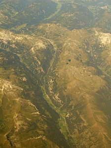
Taurach Valley
| Taurach Valley | ||
|---|---|---|
|
Aerial view, north direction; with the three valley sections: above (Pongau side near Untertauern), upper middle (Obertauern), below (Lungau side near Tweng) |
||
| location | Pongau / Lungau , State of Salzburg | |
| Waters | (Northern) and (Southern) Taurach | |
| Mountains | Hochfeind Group ( Radstädter Tauern ) / Kalkspitzen Group ( Schladminger Tauern ) | |
| Geographical location | 47 ° 15 ' N , 13 ° 33' E | |
|
|
||
| height | 850 to 1738 m above sea level A. | |
| length | 35 km | |
| particularities | Altstrasse | |
The valley of two rivers called Taurach is called the Taurach Valley , both of which arise near the Radstadt Tauern Pass , but drain in opposite directions.
The Talzug connect the Ennstal with the Murtal in north-south direction and separated in the Niedere Tauern , the group Radstadt Tauern to the west of the Schladming Tauern in the East. The valley is the second most easterly of the Salzburg Tauern valleys .
The two streams that run down from the Tauern Pass are:
- The Northern Taurach (also Pongauer Taurach ) is a right tributary of the Enns . It rises south below the Seekarspitze , east of the Tauern Pass, mainly from two streams and flows into the Enns after about 20 kilometers at Radstadt ( 858 m ). This is where the Radstadt basin of the Salzburg Enns Valley connects .
- The southern Taurach (also Lungau Taurach ) is a left tributary of the Mur and flows across the Lungau . It rises south of Obertauern and flows into the Mur at Tamsweg after about 40 kilometers . The valley ends at Mauterndorf ( 1123 m ) and flows into the Tamsweg Basin (Lungau Basin) of the Upper Mur Valley
The outer valleys are agricultural settlement areas. The inner valley of the Talszuges begins on the steep slope between Johannes case and sweeping head (Tauernhof), then passes largely flat on the 1600 m in the pass landscape of Obertauern , and ends in Twenger Talpass to Tennfall (Tauern WT). The place Obertauern is a pure ski tourism settlement of the 20th century in an alpine region.
Communities in the Taurach valleys are from north to south: Radstadt with the village of Höggen in the valley, Untertauern and Tweng (with the common village of Obertauern), and Mauterndorf.
The mountains west are the group of high enemy to Ennsquelltal - Zederhaustal , the east, the group of Kalkspitzen to Forstau Valley - Weißpriachtal . The fact that the Tauern Valley runs through without a high-alpine pass obstacle is what makes it important for traffic.
The Radstädter Tauern forms one of the historically most important Alpine crossings, the road from Roman times was almost certainly the Roman road Virunum - Iuvavum , with the Mansio In Alpe on the Tauern Pass. Today's B99 has lost its importance due to the Tauern Autobahn in the western side valley between Altenmarkt and St. Michael (Oberstes Ennstal and Zederhaustal) and its tunneling under the main Alpine ridge , the Tauern tunnel .
Web links
- Entry on Taurachtal in the Austria Forum (in the AEIOU Austria Lexicon )

