
German handles
|
German handles
|
||
|---|---|---|
| coat of arms | Austria map | |
 |
|
|
| Basic data | ||
| Country: | Austria | |
| State : | Carinthia | |
| Political District : | Sankt Veit an der Glan | |
| License plate : | SV | |
| Surface: | 71.5 km² | |
| Coordinates : | 46 ° 51 ' N , 14 ° 4' E | |
| Height : | 847 m above sea level A. | |
| Residents : | 897 (January 1, 2020) | |
| Population density : | 13 inhabitants per km² | |
| Postal code : | 9572 | |
| Area code : | 0 42 79 | |
| Community code : | 2 05 03 | |
| NUTS region | AT213 | |
| Address of the municipal administration: |
Deutsch-Griffen 23, 9572 Deutsch-Griffen |
|
| Website: | ||
| politics | ||
| Mayor : | Michael Reiner ( FPÖ ) | |
|
Municipal Council : ( 2015 ) (11 members) |
||
| Location of Deutsch-Griffen in the district of Sankt Veit an der Glan | ||
  |
||
| Source: Municipal data from Statistics Austria | ||

Deutsch-Griffen is a municipality with 897 inhabitants (as of January 1, 2020) in the Sankt Veit an der Glan district in Carinthia .
geography
Deutsch-Griffen is located in northern Carinthia around 30 kilometers northwest of Klagenfurt in a left side valley of the Gurktal on the Griffnerbach. The municipality stretches from the Gurk River to the Carinthian-Styrian border in the eastern Nock Mountains . At the northern edge of the town is the valley of Paalbaches , in the Mur drained. This barely inhabited part of the community can be accessed from the Flattnitz and can only be reached with a long detour from Deutsch Griffen and is therefore colloquially counted as part of the Flattnitz. The neighboring communities in Carinthia are Glödnitz and Albeck . In the north the community borders on Styria .
Community structure
The community consists of the only cadastral community Deutsch-Griffen. The municipality includes the following 25 localities (population in brackets as of January 1, 2020):
- Silly (13)
- Arlsdorf (10)
- Bach (43)
- Bischofsberg (22)
- Well (14)
- German handles (357)
- Faulwinkel (2)
- Gantschach (0)
- Goeschelsberg (31)
- Trench (9)
- Gray (20)
- Hintereggen (15)
- Hochrindl (4)
- Lessnitz (43)
- Meisenberg (8)
- Messaneggen (14)
- Mitteregg (57)
- Upper Lamb (3)
- Pesseneggen (10)
- Ratzendorf (2)
- Rush harrows (67)
- Sand (16)
- Pointed meadows (89)
- Tanzenberg (46)
- Lower lamb (2)
history
Griffen was first mentioned in a document in 927 as "Grivinne". Around 1043 a church was mentioned. The current parish church was first mentioned in 1157 when the Gurk bishop came into possession.
The community was constituted in 1850, although the current name did not develop until the 1860s. In 1920 there were border corrections to the neighboring municipality of Albeck . In 1973 Deutsch-Griffen was integrated into the newly formed large community of Weitensfeld-Flattnitz , but became independent again in 1991 after a referendum.
population
The municipality of Deutsch-Griffen has 1023 inhabitants (2001), 97.8% of whom are Austrian and 1.6% German citizens. 93.9% of the population profess to the Roman Catholic and 2.5% to the Protestant Church, 3.2% are without religious belief.
Economy and Infrastructure
According to the 2001 census, there are 82 employees in the municipality and 271 out-commuters. Agriculture and forestry are economically dominant. There are 96 agricultural and forestry holdings (38 of which are the main occupation), which together cultivate 5169 ha (1999). In the north of the municipality is the Hochrindl ski area , which also includes the municipality of Albeck .
Deutsch-Griffen has a connection to the Gurktal Strasse (B 93), which runs past the southern municipal boundary, via the L 64 state road .
Culture and sights
The sights of the municipality of Deutsch-Griffen include the parish church of St. James the Elder , a Romanesque building from the 12th century that was later expanded and converted into a fortified church , the crib museum in the parish hall, the mill trail and the Lenten cloth. There is a lime kiln on the Flattnitz in the municipality of Deutsch Griffen .
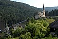
Parish Church of Saint James the Elder

Parish barn with nativity museum

Filial church hl. John the Baptist in Spitzwiesen
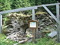
Lime firing furnace on the Flattnitz


politics
Municipal council
The municipal council consists of 11 members and has been composed as follows since the 2015 municipal council election :
The directly elected mayor is Michael Reiner (FPÖ).
coat of arms
The municipality of Deutsch-Griffen was awarded a coat of arms with the following blazon on September 12, 1995 : “In green, a silver sloping right-hand bar in the form of a corridor covered with shingles and pierced in black between brick pillars above a railing of wooden slats, accompanied by a silver Gothic finial , below by a silver uprooted spruce. ” The flag is green and white with an incorporated coat of arms.
The design of the sloping right-hand bar is based on a symbol of the community, the long staircase to the parish church of St. Jacob the Elder , located above the village . The finial indicates the decorations on the pinnacles of the triumphal arch wall to the left of the church choir. The spruce stands for the abundance of forests and their importance for both forestry and tourism.
Partner municipality
Sons and daughters of the Deutsch-Griffen community
- Gerhard Dörfler (* 1955), former politician (FPÖ, BZÖ, later FPK), Governor of Carinthia from 2008 to 2013
- Sieglinde Trannacher (1961–2015), politician ( SPÖ )
Web links
- Deutsch-Griffen municipality
- 20503 - German handles. Community data, Statistics Austria .
Individual evidence
- ↑ Statistics Austria: Population on January 1st, 2020 by locality (area status on January 1st, 2020) , ( CSV )
- ↑ Office of the Carinthian Provincial Government ( Memento of the original from May 25, 2015 in the Internet Archive ) Info: The archive link was inserted automatically and has not yet been checked. Please check the original and archive link according to the instructions and then remove this notice.
- ↑ Office of the Carinthian Provincial Government ( Memento of the original from November 18, 2015 in the Internet Archive ) Info: The archive link was automatically inserted and not yet checked. Please check the original and archive link according to the instructions and then remove this notice.
- ^ Quoted from Wilhelm Deuer: The Carinthian municipal coat of arms . Verlag des Kärntner Landesarchiv, Klagenfurt 2006, ISBN 3-900531-64-1 , p. 70
Althofen | Brückl | German handles | Eberstein | Frauenstein | Friesach | Glödnitz | Cucumber | Guttaring | Hüttenberg | Kappel am Krappfeld | Little Saint Paul | Liebenfels | Metnitz | Micheldorf | Mölbling | Sankt Georgen am Längsee | Sankt Veit an der Glan | Strasbourg | Weitensfeld in the Gurktal