Guttaring
|
market community Guttaring
|
||
|---|---|---|
| coat of arms | Austria map | |
|
|
||
| Basic data | ||
| Country: | Austria | |
| State : | Carinthia | |
| Political District : | Sankt Veit an der Glan | |
| License plate : | SV | |
| Surface: | 54.92 km² | |
| Coordinates : | 46 ° 53 ' N , 14 ° 31' E | |
| Height : | 624 m above sea level A. | |
| Residents : | 1,485 (January 1, 2020) | |
| Population density : | 27 inhabitants per km² | |
| Postal code : | 9334 | |
| Area code : | 0 42 62 | |
| Community code : | 2 05 09 | |
| NUTS region | AT213 | |
| Address of the municipal administration: |
Unterer Markt 3 9334 Guttaring |
|
| Website: | ||
| politics | ||
| Mayor : | Herbert Kuss ( FPÖ ) | |
|
Municipal Council : ( 2015 ) (15 members) |
||
| Location of Guttaring in the Sankt Veit an der Glan district | ||

|
||
| Source: Municipal data from Statistics Austria | ||
Guttaring is a market town with 1485 inhabitants (as of January 1, 2020) in the north of Carinthia in Austria .
geography
The municipality is located in a basin-like landscape open to the south (Guttaringer Basin) between Krappfeld and Görtschitztal and is traversed by the Silberbach.
Community structure
Guttaring is divided into seven cadastral communities (Baierberg, Deinsberg, Guttaring, Guttaringberg, Hollersberg, Verlosnitz, Waitschach) and comprises the following 24 localities (population in brackets as of January 1, 2020):
- Baierberg (47)
- Dachberg (13)
- Deinsberg (65)
- Dobrich (1)
- Gobertal (11)
- Guttaring (901)
- Guttaringberg (60)
- Höffern (15)
- Hollersberg (80)
- Maria Hilf (5)
- Oberstranach (8)
- Rabachboden (17)
- Rat digging (21)
- Schalkendorf (5)
- Schelmberg (20)
- Schrottenbach (0)
- Sonnberg (4)
- St. Gertruden (2)
- Übersberg (95)
- Urtl (34)
- Urtlgraben (45)
- Verlosnitz (6)
- Waitschach (18)
- Wine Village (12)
history
Antiquity
The area around Deinsberg with the former parish church is historically significant. The Roman inscription stones walled into the western vestibule bear witness to an early settlement of this area above today's community center, which used to be a marshland.
middle Ages
Today's municipality came into the possession of the Archdiocese of Salzburg in the 10th century , which established the mother parish for the entire upper Görtschitztal and made Guttaring the seat of an archbishop's office. In August 1201, a synod was held under the Salzburg Archbishop Eberhard II and in the presence of the future Duke Bernhard von Spanheim . Near Friesach was the most important city in Carinthia at that time. In 1346 the place was given a keep , which is still in ruins today. Guttaring suffered from a number of catastrophes, including the earthquake of January 25, 1348, which, as in almost all of Carinthia, caused complete destruction. In 1469 and 1476 there were devastating Turkish invasions, in 1483 there was a plague of locusts and in 1348 the plague raged . Towards the end of the Middle Ages (between 1438 and 1505) the parish was occupied from Rome, which indicates its importance at the time.
Modern times
In 1542 it was raised to the market by Archbishop Ernst von Salzburg. The community of Guttaring, formed in 1850, grew in 1865 through the incorporation of Waitschach. The plague hit Guttaring again in 1715, with 399 dead.
The historical iron production in the Noric region, especially on the nearby Hüttenberger Erzberg and in the Lölling , made Guttaring a place of passage and resting place on the way to Althofen . In Guttaring itself, however , iron was smelted in a raft furnace , one of the oldest of its type in Europe, in the Urtlgraben until 1834 . A lignite deposit was mined on the Sonnberg , which was first mentioned in 1773. This coal was used to produce alum and iron (II) sulphate until 1839 , but it was unsuitable for iron production because of its high sulfur content. After several changes of ownership - including Treibacher Industrie AG - the mining industry finally came to a standstill in 1939 due to the exhaustion of the deposits.
In 1973 Guttaring became a smaller part of the dissolved municipality of Wieting.
population
According to the 2017 census, Guttaring has 1,481 inhabitants, the vast majority of whom are Catholics.
Culture and sights
- Parish church Guttaring : The Romanesque-Gothic parish church of St. Rupert with its baroque high altar, which was first mentioned in a document as early as 1160, is of cultural significance.
- Dobritsch parish church : on Guttaringberg on the border with the municipality of Friesach
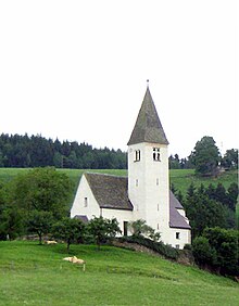
- Filialkirche Deinsberg : In the course of a restoration in 1968 and 1969, valuable wall frescoes from the middle of the 14th century were discovered and uncovered in the former parish and today's subsidiary church.
- Karner: To the north of the church there is a remarkable Karner , a Romanesque round building with a bay-shaped eastern apse .
- Maria Hilf ob Guttaring : The late baroque pilgrimage church Maria Hilf is clearly visible above the town.
- Maria Waitschach : The high altitude late Gothic pilgrimage church is a former branch church of Guttaring and is also a popular hiking destination.
- The ruins of a raft furnace from the 16th century with an adjacent rest station - the former so-called Verweserhaus - in the Urtl bear witness to historical iron mining.
- A special feature of the place is the “field of stone lenses” between Guttaring and St. Gertraud, where you can easily find fossils , so-called nummulites , which are reminiscent of lenses in shape and size .
- Guttaring has a number of well-tended hiking trails that are precisely documented using GPS data and which can be used to get to the various churches.
- Founded in 1872, the Guttaring men's choir is one of the oldest choral societies in Carinthia.
- Willi's beer museum
Economy and Infrastructure
Agriculture , wood processing and tourism are of certain economic importance. Ferdinand Kassl's inn is well known beyond the region. The most important company is the Stingl machine factory, which produces machines and control systems for the wood and sawmill industry. Numerous employees commute, especially to the neighboring community of Althofen .
politics
City council and mayor
The municipal council consists of 15 members and has been composed as follows since the municipal council election in 2015 :
Directly elected mayor after the mayoral election in 2015 is Herbert Kuss (FPÖ).
coat of arms
On September 8, 1618, King Ferdinand II awarded the Markt Guttaring a coat of arms, which shows the parish patron Rupert , the first Salzburg bishop, in episcopal vestments .
The blazon of the coat of arms reads: “In the blue shield [growing], facing the beholder, St. Rupert in episcopal regalia with white [silver] alb, red [gold-lined] vespers cloak and gold inful, in his right hand a gold chalice in front of his chest and in the left holding a golden bishop's staff. "
Personalities
Sons and daughters of the church
- Josef Wolfgang Dobernig (1862–1918), politician and journalist
literature
- Egon Kaiser: 120 years of the Guttaring volunteer fire brigade . Festschrift for the Guttaring market and its fire brigade, 1999.
- Evelin Pirker, Dietmar Wanko: The Noric Region . Styria, 1995, ISBN 3-222-12349-7 , pp. 44-59.
- Valentin Ramschak: Guttaring community. Chronicle . Guttaring 1992.
- Notifications from the market town of Guttaring: official notification. Periodical publication since 2010
- Guttaring parish letter. Periodical publication since 1990
Web links
- Guttaring market town
- 20509 - Guttaring. Community data, Statistics Austria .
Individual evidence
- ↑ Statistics Austria: Population on January 1st, 2020 by locality (area status on January 1st, 2020) , ( CSV )
- ↑ Office of the Carinthian Provincial Government: Municipal Council Election 2015 ( Memento of the original from August 15, 2015 in the Internet Archive ) Info: The archive link was inserted automatically and has not yet been checked. Please check the original and archive link according to the instructions and then remove this notice.
- ^ Quoted from Wilhelm Deuer: The Carinthian municipal coat of arms . Verlag des Kärntner Landesarchiv, Klagenfurt 2006, ISBN 3-900531-64-1 , p. 132


