High wall
| High wall | ||
|---|---|---|
|
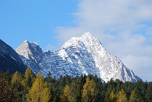
High face from the Inn Valley (from the southeast) |
||
| height | 2719 m above sea level A. | |
| location | Tyrol , Austria | |
| Mountains | Mieming chain | |
| Dominance | 1.9 km → Hochplattig | |
| Notch height | 402 m ↓ Alplscharte | |
| Coordinates | 47 ° 21 '32 " N , 11 ° 0' 46" E | |
|
|
||
| rock | Wetterstein lime | |
| Age of the rock | Ladinium - Carnium | |
| First ascent | Hermann von Barth August 9, 1873 | |
| Normal way | Rise from the south, UIAA I | |
|
The high face from the Gaistal (from the east) |
||
The high wall , also high wall or dead wall , is a 2719 m above sea level. A. , according to other information, 2721 m high mountain in the Mieminger Mountains in Tyrol , Austria .
Location and surroundings
The high wall is located in the eastern section of the Mieminger chain north of Telfs in the Inn Valley . The south face of the mountain above the Alpltals is craggy ground , in deeper regions also Laces belts and dumps embossed, pierced by a vertical broken rocks ( "Dead wall"). In the south-west, the high face is separated from the Hochplattig by the 2317 m high Alplscharte , the highest peak in the Mieminger Mountains at 2768 m . In the north-west is the Schwarbachkar , in the north and north-east the high face with up to 1000 meter high rock walls drops steeply down to the Gaistal , at the foot of which firn fields can hold all year round . To the southeast, a ridge runs over the 2,469 m high Karkopf to the Niedere Munde crossing ( 2,059 m ), to which the Hohe Munde ( 2,662 m ) connects.
The main summit of the high wall is preceded by a 2715 m high secondary summit ( 47 ° 21 ′ N , 11 ° 1 ′ E ) about 200 meters southwest , which also bears the summit cross .
ways
The Alplhütte ( 1504 m ) or the Strassberghaus ( 1191 m ) above Telfs serve as a starting point for climbing the high face on the normal route . The increase leads as a marked trail that however slight climb in difficulty I (UIAA) requires, on the southern flank to the southwest summit. The pathless transition to the main summit also has difficulty level I, the rock here, as on the normal route, is very brittle. The first ascent succeeded Hermann von Barth on August 9, 1873rd
From the Karkopf or the Niedere Munde, the high face can be climbed via the southeast ridge (II). The south-west ridge of the Alplscharte is more demanding with a difficulty of III, as are various routes through the west and north-west faces, which are considered extremely fragile. More important climbing routes lead from the Gaistal through the harder rock of the north face, such as the north-west ridge (IV) , the north face through the Schnöllkar (V), the north-east ridge (IV) or the north face to the north-east ridge (IV).
Other climbing routes run through the Dead Wall on the south flank, such as the south face ( VI A1) and the south face intersection (V).
geology
Like its neighboring mountains , the high face is built from Wetterstein limestone , a rock from the Triassic . This also forms large parts of the breccias that cover the southern flank. Rocks from the Raibler strata lie underneath ; the main dolomite can be found even deeper .
The geologist and alpinist Otto Ampferer succeeded in the first ascent of the southwest ridge in the course of his geological studies on the high face on September 25, 1897 .
On March 23, 2012, the largest rock fall in Tyrol for several decades occurred on the south side of the high face. The rock masses penetrated over two kilometers into the Alpltal and destroyed the small power station of the Alplhütte.
Web links
Individual evidence
- ↑ a b c Alpine Club Map No. 4/2 Wetterstein Mitte, 2002
- ↑ Federal Office for Metrology and Surveying : Austrian Map 1: 50,000, AMAP Online , accessed on October 9, 2011
- ↑ a b c d e f Rudolf Wutscher: Mieminger chain. A guide for valleys, huts and mountains (= Alpine Club Guide . Eastern Alps. ). Written according to the guidelines of the UIAA. Bergverlag Rother, Munich 1989, ISBN 3-7633-1099-1 , pp. 110-120.
- ^ Otto Ampferer : About hanging breccias of the northern limestone Alps. A suggestion for further research. In: Yearbook of the Imperial Royal Geological Institute. Vol. 57, No. 4, 1907, ZDB -ID 217948-9 , pp. 727-752, here pp. 746-747, ( digital copy (PDF; 1.49 MB) ).
- ↑ A massive rock fall in the Oberland , orf.at from March 31, 2012, accessed on March 31, 2012


