Pfafflar
|
Pfafflar
|
||
|---|---|---|
| coat of arms | Austria map | |
|
|
||
| Basic data | ||
| Country: | Austria | |
| State : | Tyrol | |
| Political District : | Reutte | |
| License plate : | RE | |
| Main town : | Bschlabs | |
| Surface: | 33.59 km² | |
| Coordinates : | 47 ° 17 ' N , 10 ° 37' E | |
| Height : | 1314 m above sea level A. | |
| Residents : | 105 (January 1, 2020) | |
| Population density : | 3.1 inhabitants per km² | |
| Postal code : | 6647 | |
| Area code : | 05635 | |
| Community code : | 7 08 25 | |
| NUTS region | AT331 | |
| politics | ||
| Mayor : | Bernd Huber | |
|
Municipal Council : (2016) (9 members) |
||
| Location of Pfafflar in the Reutte district | ||
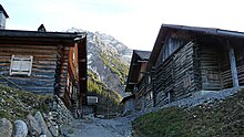
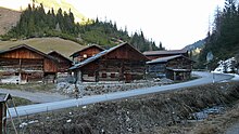
 Village of Boden in Pfafflar |
||
| Source: Municipal data from Statistics Austria | ||
Pfafflar is a municipality with 105 inhabitants (as of January 1, 2020) in the Reutte district in Tyrol ( Austria ). The community is located in the judicial district of Reutte .
geography
Pfafflar is located in the Bschlabertal , a side valley of the Lech Valley . Here, the road (L72 extends Hahntennjoch / L266 Bschlaber road ) from Lech via the Hahntennjoch (the border is the community) to Imst in Oberinntal that for the upper Lech a shorter distance than over the remote pass represents.
Community structure
The municipality includes the following two localities (residents as of January 1, 2020):
- Floor (41)
- Bschlabs (64)
In addition, there is the not permanently inhabited part of the municipality Pfafflar, after which the cadastral community and counting district are named. Bschlabs is the capital of the municipality .
Neighboring communities
| Elmen | Stanzach | |
| Häselgehr |

|
|
| Imst ∗ ( Bez. Imst ) |
The neighboring cadastral communities run analogously, as all neighboring communities only include one cadastral community.
- ∗The Imst area comprises the majority of the municipality ( Namloser Wetterspitze in the northeast to Lichtspitze in the southwest). Namlos in the northeast and Gramais in the southwest do not border.
history
Originally, the first settlement took place in Pfafflar. Today only Bschlabs and Boden are settled all year round, Pfafflar is just a kind of alpine village, the houses of which are partly inhabited by holiday guests in summer.
Place name
To 1284 Pfafflar was Pavelaers called the Romansh word from pabulariu derived and feed censure means.
Middle Ages and early modern times
The first permanent settlers in this side valley of the Lechtal were refugees from the Engadin who were persecuted for their beliefs. They received permission from Count Starkenberg from Imst to colonize the valley. The Swiss came with their cattle over the Hahntennjoch (formerly called Hohentennen), a pass that connects the Lech Valley with the Inn Valley, and settled in Pfafflar around 1280. According to documents, there were four Schwaighöfe there in 1284 . Then courtyards were built in Bislafes (today's Bschlabs) and Boden.
The settlers cleared forests in order to have meadows for cattle breeding (goats, sheep, cows) and arable farming (potatoes, grain, flax and beans). So they were economically independent. Back then, life in the mountains was an uphill battle for survival. The mountain meadows were partly mowed up to an altitude of 2,300 m in order to have hay for the cattle in winter. Some oral traditions say that mining was carried out above the Boden district, at the foot of the Rotkopf. Was mined calamine and lead. A small mountain tunnel below the Rotkopf still testifies to this today.
In 1500 the area around Pfafflar was a popular hunting area for Prince Maximilian.
In 1629 the valley was combined into a tax district of the Imst court. In 1811 the settlement was declared a tax and in 1848/49 a local municipality (political municipality) Pfafflar. Pfafflar reached its highest population in 1840 with 320 residents. These lived mostly from the yield of the barren agriculture.
In 1894 the district of Pfafflar was left as a permanent settlement and the mountain farmers moved into the ground 250 m lower. However, Pfafflar was still used as a summer settlement, where the farmers stayed from spring to late autumn.
During the First World War, ten men from Bschlabs and Boden fell as soldiers in Lemberg (Ukraine), Russia, Hungary, Italy and Vienna for the fatherland.
In 1930 a road from Elmen to Bschlabs was built. About five years later from Boden towards Bschlabs. The first car could drive to Bschlabs in 1937, but not to Boden until 1947. Pfafflar was part of the Imst district until 1938 and part of the Imst judicial district until 1947 . Due to the road connection into the Lechtal, the Bschlabertal was politically assigned to the Reutte district in 1938.
During the Second World War, eight men from the community died as soldiers in Africa, Russia, Romania, Silesia, Italy and Yugoslavia.
post war period
The municipality of Pfafflar has had electricity since 1954.
In 1960 one began with the avalanche protection barriers (steel snow bridges, afforestation, avalanche galleries and under tunnels) in order to make the places and especially the access road safer in winter. Before these protective measures, the municipality of Pfafflar had the most avalanche-prone access road of all municipalities in Austria (e.g. in the winter of 1981/82 the places in the municipality were cut off from the outside world for a total of 80 days, which in turn resulted in the highest population decline of all municipalities in Austria in the following years) .
With the opening of the Hahntennjochstraße in 1969 - at least for the summer months - the sleepy village of Bschlabs became more lively due to the heavy through traffic. In addition to a traffic connection, it is now a popular excursion route among motorcyclists and cyclists, although it is closed in the winter months.
During this time, technical progress did not stop at the municipality of Pfafflar. Radio and television reception improved and the Internet made its way. The everyday life of the mountain farmers was made much easier by new agricultural machines. Despite many improvements, the emigration of young people from the valley could not be stopped. Associations such as the music band, which enriched cultural and church life, disbanded due to a lack of members.
In recent years, film teams have repeatedly appeared in the community to make feature films and TV films such as Der Bergdoktor , Christmas Wolf , Apollonia , The Reconciliation , The Architect and The Midwife .
At the end of the 2013/14 school year, the single-class elementary school in Bschlabs was closed.
coat of arms
The colors of the municipality flag are yellow-green.
The coat of arms symbolizes the name of the community, which in its oldest known form is Pavelaers and means 'at the feeding towns'. It is a reminder of the beginnings of settlement and, with the three number, of the villages of Pfafflar, Bschlabs and Boden.
The Tyrolean state government awarded the coat of arms to the municipality of Pfafflar at its meeting on May 19, 1981.
Population development

Culture and sights
literature
- Florian Gasser: How a valley dies. In: The time. July 28, 2011, accessed July 30, 2011 .
- Frank Haun: The mountain villages of the Tyrolean side valleys of the upper Lech. Namlos, Pfafflar, Gramais, Kaisers, Hinterhornbach. In: Contributions to Alpine Economic and Social Research 116, 1971.
- Gertraud Jandorek-Ebner: Settlement and economic history of the high mountain valleys Pfafflar and Namlos. Diss. Univ. Innsbruck 1944.
historical novels:
- Walter Lechleitner: The sworn valley . ISBN 978-3-901821-18-9 .
- Walter Lechleitner: savior of the homeland . ISBN 978-3-901821-19-6 .
Web links
- Entry on Pfafflar in the Austria Forum (in the AEIOU Austria Lexicon )
- 70825 - Pfafflar. Community data, Statistics Austria .
- Pfafflar , in History Tyrol
- Forgotten Bschlabertal , photo gallery, time online, July 2011
Individual evidence
- ↑ Statistics Austria: Population on January 1st, 2020 by locality (area status on January 1st, 2020) , ( CSV )
- ↑ Extract from a Pfafflar certificate


