
Bach (Tyrol)
|
Brook
|
||
|---|---|---|
| coat of arms | Austria map | |
 |
|
|
| Basic data | ||
| Country: | Austria | |
| State : | Tyrol | |
| Political District : | Reutte | |
| License plate : | RE | |
| Surface: | 56.86 km² | |
| Coordinates : | 47 ° 16 ′ N , 10 ° 24 ′ E | |
| Height : | 1070 m above sea level A. | |
| Residents : | 623 (January 1, 2020) | |
| Postal code : | 6653 | |
| Area code : | 05634 | |
| Community code : | 7 08 01 | |
| NUTS region | AT331 | |
| Address of the municipal administration: |
Oberbach 90 6653 Bach |
|
| Website: | ||
| politics | ||
| Mayor : | Egon Brandhofer | |
|
Municipal Council : (2016) (11 members) |
||
| Location of Bach in the Reutte district | ||
  |
||
 View of Bach in the Lechtal |
||
| Source: Municipal data from Statistics Austria | ||

Bach is a municipality with 623 inhabitants (as of January 1, 2020) in the Reutte district in Tyrol ( Austria ). Bach belongs to the judicial district of Reutte .
geography
Bach is located in the upper Lech Valley , four bodies of water flow through the municipality, two larger bodies of water, these are the river Lech (Tiroler Lech Nature Park) and the Alperschonbach and two smaller bodies of water: the Modertalbach and the Sulzlbach. The altitude is 1070 meters.
Community structure
Bach consists of a single cadastral municipality of the same name or three localities (residents as of January 1, 2020):
- Bach (399)
- Schoenau (53)
- Stockach (171)
|
structure
|
||||||
|
Legend for the breakdown table
|
The settlement is formed by several hamlets and farm groups and consists of the following districts: Kraichen, Sulzlbach, Schönau, Stockach, Winkl, Unterbach, Oberbach, Benglerwald, Seesumpf, Klapf and Bichl.
Neighboring communities
Five of the six neighboring communities are in the Reutte district.
| Elbigenalp | Häselgehr | |
| Holzgau |
.svg)
|
Gramais |
| Emperor | Zams ( Landeck district ) |
history
Bach was first mentioned in a document in 1427. Frescoed houses are a reminder of the former seasonal workers in the Lech Valley who moved abroad. As is often the case in the Lechtal, the municipality of Bach was settled very late. In order to obtain new land and new farms, landlords commissioned farmers to clear land and then maintain it in a special feudal relationship.
Bach was subordinate to the Ehrenberg court and was assigned to the Mitter-Lechtal attorney around 1500 . In the Ehrenberg court around 1649, the political communities were referred to as parishes, with Bach being part of the Elbigenalp parish . Until 1854 Bach was always referred to as Stockach , only in the following time did the community name Bach come into use.
Population development

politics
The municipal council has 11 members.
- With the municipal council and mayor elections in Tyrol in 2016, the municipal council has the following distribution: 7 together for the municipality of Bach, 2 village community of Bach, 1 for one another in the municipality of Bach, 1 We Bacher for Bach.
- mayor
- until 2010 Albert Wolf (ÖVP)
- since 2010 Egon Brandhofer (ÖVP)
coat of arms
Blazon :
- "In silver, a right blue sloping bar with three silver fish jumping upwards and turning to the right."
The municipal coat of arms, awarded on October 30, 1973, symbolizes the place name as a talking coat of arms .
Tourism and economy
Bach is a two-season tourist municipality . The place is the starting point for many mountain hikes (e.g. in the Madautal , the Sulztal and via a lift to the 2226 m high Jöchelspitze ).
In summer you can hike numerous alpine pastures and huts from Bach (e.g. Madau, Sulzlalm, Baumgartalm, Sonnalm, Frederic-Simmshütte , Memminger Hütte , Ansbacher Hütte , Württemberger Haus ). Furthermore, some themed and long-distance hiking trails lead through Bach:
- The European long-distance hiking trail E5 branches off at Bach into the Madautal.
- The long-distance hiking trail - Lechweg has been running through Bach since July 2012 .
- The Lechtaler Panoramaweg leads from the mountain station of the Jöchelspitzbahn to the Bernhardseckhütte.
- Botanical nature trail leads from the mountain station of the Lechtaler Bergbahnen to the nearby Lachenkopf and directly to the Lechtaler Heuberg Museum.
- The Anna Stainer-Knittel Memorial Trail leads from the center of Bach in the direction of Madau to the Saxer Alm. Nine stations tell about the artistic career, the family history and the ups and downs of her career.
In winter there are numerous trails and a Nordic WISBI training route. This is a training slope with permanent timekeeping. Additional cross-country trails are available in the meadows between Bach and Stockach with timekeeping. Of course, the community also lives from the Jöchelspitze ski area or the nearby ski area in Warth .
There are many hotels, grocery stores, inns and businesses in Bach. However, many residents of the community also commute to their workplaces in the surrounding areas or to Reutte .
Power generation
The community has its own drinking water power plant with an annual output of around 700,000 kWh. If necessary, the water can be pumped back into an elevated tank around 70 m higher. This system is a milestone for the whole community and secures the community budget.
| Technical data for the system | |
|---|---|
| Amount of water | 30 l / s |
| Gross head | 420 m |
| Expansion capacity | 155 kW |
| Pressure line | 2.2 km |
| planning | Alpecon culture technology |
| Laying & civil engineering | Swietelsky |

Panoramaweg Bach

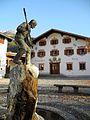
Saint Nepomuk on the Lech Bridge

View of the parish church

The turquoise-blue Lech near Bach
Klotzkapelle with memorial plaques (towards Madautal)
Village square with fountain (autumn)
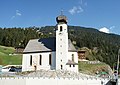
Bach parish church

View of Bach and the Lechtal Alps (winter)


Culture and sights

- Parish Church of Our Lady of the Purification : The church was built between 1790 and 1792 and, like almost all Lechtal churches, stands on a rock safely above the floods of the Lech. In 1992/93 an interior renovation was carried out and the original baroque state was restored. Next door is the cemetery with a cemetery chapel and a war memorial.
- The Lech Bridge near the church as a cable-stayed bridge was rebuilt in 2009 after the flood in 2005. The rectory was demolished.
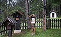
- Swamp chapel
- Anthony's Chapel
- Local chapel Schönau
- Expositur Church of St. Joseph in Oberstockach
- Log chapel and cemetery
- Heuberg Museum on the Jöchelspitze
- Modertal waterfall Seesumpf
Personalities
- Anselm Klotz from the Stockach district conquered the Freispitze for the first time and, in 1875, the Parseierspitze from the Lechtal side.
- Josef Alois Knittel (1814–1875), the Freiburg sculptor, was born in the Oberbach district.
- Karl Selb (1760–1819), painter and lithographer from Unterstockach, teacher of Anton Falger (1791–1876), also a painter and lithographer.
- Toni Knittel (* 1963), artist name Bluatschink , is a well-known singer, songwriter and author of the musical Ritter Rüdiger and the well-known Lechtalmesse .
Individual evidence
- ↑ Statistics Austria: Population on January 1st, 2020 by locality (area status on January 1st, 2020) , ( CSV )
- ↑ Provincial Law Gazette for Tyrol No. 84/1973 (digitized version )
- ↑ lechtal-info.com
- ↑ Lech Bridge Bach. Swietelsky, March 12, 2009, archived from the original on January 16, 2014 ; accessed on March 30, 2013 .
Web links
- 70801 - Bach. Community data, Statistics Austria .
- History-Tyrol: Bach
Bach | Berwang | Biberwier | Bichlbach | Breitenwang | Ehenbichl | Ehrwald | Elbigenalp | Elmen | Forchach | Grän | Gramais | Häselgehr | Heiterwang | Hinterhornbach | Courtyards | Holzgau | Young wood | Emperor | Lechaschau | Lermoos | Musau | Nameless | Nesselwängle | Pfafflar | Pflach | Pinswang | Reutte | Schattwald | Stanzach | Steeg | Tannheim | Vils | Vorderhornbach | Wängle | Weißenbach am Lech | Zöblen