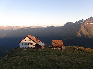
Ansbacher Hut
| Ansbacher hut DAV hut category I |
||
|---|---|---|
|
Ansbacher Hut |
||
| location | Southeast slope of the Samspitze; Tyrol , Austria ; Valley location: Schnann , Flirsch | |
| Mountain range | Lechtal Alps | |
| Geographical location: | 47 ° 10 '6 " N , 10 ° 24' 11" E | |
| Altitude | 2376 m above sea level A. | |
|
|
||
| owner | Section Ansbach of the DAV | |
| Built | 1906 | |
| Construction type | hut | |
| Usual opening times | Early July to late September | |
| accommodation | 0 beds, 88 beds | |
| Winter room | 16 bearings | |
| Web link | Ansbacher Hut | |
| Hut directory | ÖAV DAV | |
The Ansbacher Hütte is an alpine club hut of the Ansbach section of the German Alpine Club in the Lechtal Alps , Tyrol , Austria .
location
The Ansbacher Hut, built in 1906, is located at 2376 m above sea level. A. on the southeast slope of the Samspitze, in the municipality of Flirsch , directly on the border with Pettneu am Arlberg .
Accesses
- from Schnann , ascent on the southern slope via the Fritzhütte ( 1800 m ), walking time: 3½ hours,
- from Schnann, along the Schnanner Bach to the Alperschon Joch and over the Flarsch Joch, walking time: 4 hours
- from Flirsch , ascent on the southern slope, walking time 4 hours
- from Bach via Madau, up the Alperschon valley to Knappenboden, on over the Flarsch-Joch, walking time: 5 hours
Neighboring huts and crossings
- To the Kaiserjochhaus via Flarschjoch, Alperschonjoch, Hinterseejoch and Kridlonscharte, 4½ hours. The crossing of the frontseespitze O-ridge is rope insured, inexperienced people should only walk in the company of experienced hikers or guides.
- To the Memminger Hütte over the Winterjoch and the Grießscharte, 5½ hours, rope insurance on the descent from the Grießscharte, which can be uncomfortable when iced over. Inexperienced people should only undertake the path in the company of experienced mountain hikers or guides.
- To the Simmshütte via Flarschjoch, Stierlahnzugjoch and Kälberlahnzugjöchl, 4½ hours.
- To the Augsburger Hütte via the Augsburger Höhenweg , 8–10 hours. This path is a long and demanding high-altitude path, which can cause problems even for experienced people in poor conditions, especially the ice on the northern slopes to be crossed. Inexperienced people should definitely only undertake the path in the company of experienced mountain hikers or guides.
summit
- Samspitze ( 2624 m ), marked trail, ¾ hour
- Feuerspitze ( 2851 m ), marked trail, 3 hours
- Freispitze ( 2884 m ), pathless, short climbing up to difficulty level II , 4½ hours
- Grießlspitze ( 2830 m ), pathless, short climbing up to difficulty level II, 2 hours
- Frontseespitze ( 2889 m ), pathless, climbing up to difficulty level II, 3½ hours
- Fallenbacherspitze ( 2723 m ), pathless, short climbing up to difficulty level II, 3 hours
- Stierkopf ( 2589 m ), unmarked path, ½ hour
cards
- Alpine Club Map 3/3 Lechtal Alps - Parseierspitze (1: 25,000)
literature
- Dietmar Weiss, Herbert Jauernig, Norbert Meindorfer: 100 years of Ansbacher Hut - a gem in the Lechtal Alps . In: DAV Panorama . No. 2 , April 2006, ISSN 1437-5923 , p. 72-76 ( PDF , 2.1 MB).

