Ulm Hut
| Ulmer hut DAV hut category II |
||
|---|---|---|
|
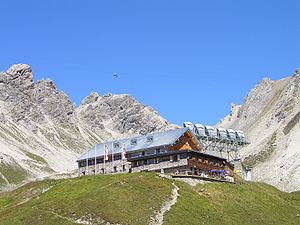
Ulmer hut with Valluga cable car and telecommunication antennas |
||
| location | upper Valfagehrkar; Vorarlberg , Austria | |
| Mountain range | Lechtal Alps | |
| Geographical location: | 47 ° 8 '49 " N , 10 ° 12' 33" E | |
| Altitude | 2288 m above sea level A. | |
|
|
||
| owner | DAV - Ulm section | |
| Built | 1903 | |
| Construction type | hut | |
| Usual opening times | Mid-July to mid-September, December to April | |
| accommodation | 52 beds, 0 camps , 10 emergency camps | |
| Winter room | no | |
| Web link | Ulm Hut | |
| Hut directory | ÖAV DAV | |
The Ulmer Hütte is an alpine club hut of the Ulm section of the German Alpine Club in Vorarlberg . It is located in the Lechtal Alps at an altitude of 2288 m above sea level. A. The Ulmer Hütte was built in 1903 and has been expanded repeatedly since then.
location
The cabin is today in the midst of the ski resort of St. Anton and St. Christoph am Arlberg . However, it is still located in the municipality of Klösterle in Vorarlberg , 400 meters southeast of the hut is the border with the state of Tyrol . Other places nearby are Stuben , Lech and Zürs .
reachability
In summer the Ulmer Hütte is a base on the Lechtaler Höhenweg. At the same time, the Ulm DAV section has developed a wide network of hiking and trails in all lengths and difficulties.
- The easiest access is from St. Anton am Arlberg with the cable car to the Galzig and on the marked path over the Arlensattel, 1½ hours or with the cable car to the Vallugaschulter and descent over the Valfagehrjoch , marked path.
- from St. Christoph am Arlberg , 1½ hours
- from the Alpe Rauz car park (2 hours)
- from St. Anton am Arlberg through the Steißbachtal, 3 hours
In winter the hut can be reached via various lifts and slopes. Ski tourers can reach the Valluga from the hut .
- The hut can be reached via the Valfagehrbahn chairlift from Alpe Rauz on the Arlbergpassstrasse.
Neighboring huts and crossings
- to the Stuttgarter Hütte over the Vallugaschulter, Schrofen with rope insurance, approx. 3½ hours. The summit of the Valluga can be "taken with you", marked path, Schrofen, approx. 1 hour more effort.
- to the Stuttgarter Hütte via the Trittscharte and the Robert-Bosch-Weg , 3 hours. The descent from the Trittscharte is very problematic in late summer / autumn due to the bare ice of the Pazielferner without crampons. In addition, an unstable block slope was exposed due to the glacier retreat below the notch (as of September 2012).
- to the Leutkircher hut over the Valfagehrjoch. The crossing of the southern slope of the Weißschrofenspitze leads through a terrain that is considered a bit unsafe and easily prone to falling rocks, here also rope insurance. From the Kapall junction, you can take a parallel path to the south, below, to Bacheregg, from where you return to the path to the Leutkircher hut.
- to the Kaltenberghütte via St. Christoph in four hours.
Hikes and via ferrata (selection)
- Trittkopf 2719 m - walking time 2½ hours
- Valluga 2808 m - walking time 2 hours
- Schindlerspitze 2647 m - walking time 1½ hours
- Arlberger via ferrata - walking time to the start 1 hour (complete walking time: approx. 4 hours)
cards
- Alpine club map 3/2 Lechtal Alps - Arlberg area (1: 25,000)
literature
- Dieter Seibert: AVF Lechtaler Alpen alpin , Bergverlag Rother , ISBN 3-7633-1268-4
- Heinz Groth, Rudolf Wutscher: Area Guide Lechtal Alps , Bergverlag Rother, ISBN 978-3-7633-3261-8


