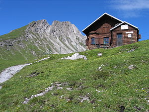
Loreahütte
| Loreahütte DAV self-catering hut category I. |
||
|---|---|---|
|
View over the Loreahütte to the Loreakopf |
||
| Mountain range | Lechtal Alps | |
| Geographical location: | 47 ° 20 '47 " N , 10 ° 47' 29" E | |
| Altitude | 2018 m above sea level A. | |
|
|
||
| owner | DAV - Isar Valley Section | |
| Construction type | Self-catering hut | |
| Usual opening times | June to the end of September, SAT / SUN partially supervised, groups please contact the section. | |
| accommodation | 0 beds, 20 camps | |
| Web link | Hut website | |
| Hut directory | ÖAV DAV | |
The Loreahütte (also Otto-Reinhardt-Hütte ) is an alpine club hut of the Isar Valley section of the German Alpine Club in the Lechtal Alps , Tyrol , Austria . It is a self-catering hut and is accessible from June to the end of September with the help of an Alpine Club key.
location
The Loreahütte is located at an altitude of 2018 m , southeast of the Loreakopf over the Fernpass or Nassereith . It lies on an elongated ridge of grass to the south above the Loreaalm. A cable car from Nassereith to the hut planned by the community in the 1960s was never realized.
history
After the Isartal Alpine Club Section, founded in 1918, was awarded the Lorea Group as a work area in 1921, the section soon began planning the construction of a shelter. After initial tough resistance on the part of the community board, it was finally possible in autumn 1926 to reach a consensus with the Nassereith community on the acquisition of 1342 square meters of building land for the hut. In the early summer of 1927, construction work began under the direction of a Nassereither carpenter and on September 2, 1928, the accommodation was officially opened.
After the Second World War, the hut, which had been badly damaged by looters, had to be repaired. In 1960 the roof was renewed, the now weathered wooden shingles were replaced by sheet metal, and in 1961 the attic was converted into a bedroom. After the renovation of the kitchen in 1967, the building was expanded in 1973/74.
The water supply from a spring set up in 1971 was supplemented by another spring and a storage tank in 1977, and electrical lighting was installed in the same year. The diesel generator connected for this purpose was replaced in 1982 by a wind turbine on the chimney and in 1987 by a photovoltaic system.
Surname
The accommodation was built as a Lorea hut. After the death of the longstanding first chairman of the section, Otto Reinhardt, the section decided in 1953 to give the hut the nickname Otto-Reinhardt-Hütte in order to honor his services to the hut and the section. In official publications by the DAV (and the section), however, the shelter is primarily listed under the original name of Loreahütte.
Accesses
- from Fernsteinsee southwest of the Fernpass, 3 hours ( geographic coordinates )
Neighboring huts and crossings
- to the Anhalter Hut via Loreascharte, Heimbachtal, Tegestal and the Hintere Tarrenton-Alpe, 8 hours
- to the Heiterwandhütte via Loreascharte, Heimbachtal, Tegestal and Reisenschuhtal, 5 hours
- to the Wolfratshauser Hütte via the eastern Kreuzjoch, Bichlbächler Jöchle, Gartnerwand and Grubigstein , 8½ hours, partially exposed.
summit
- Loreakopf , 2471 m, marked trail, 1½ hours
- Eastern Kreuzjoch, 2236 m, marked trail, 1½ hours
- Roter Stein , 2366 m, marked trail, 2½ hours
- Tagweide, 2128 m, difficulty level I, 1½ hours
cards
- Alpine Club Map 4/1 Wetterstein and Mieminger Mountains - West (1: 25,000)
Sources and literature
- Heinz Groth: Alpine Club Leader Lechtaler Alpen , Bergverlag Rother , Munich
Web links
- DAV section Isartal - Festschrift for the 75th anniversary. (PDF) DAV section Isartal, accessed on September 4, 2014 .
- 50 years of Lorea - Otto-Reinhard-Hütte. (PDF) DAV section Isartal, accessed on September 4, 2014 .

