Grubigstein
| Grubigstein | ||
|---|---|---|
|
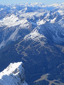
Grubigstein seen from the Zugspitze ; Ehrwald in the foreground; Biberwier left and Lermoos right on the mountain flank |
||
| height | 2233 m above sea level A. | |
| location | Tyrol , Austria | |
| Mountains | Lechtal Alps ( Northern Limestone Alps ) | |
| Dominance | 0.1 km → Gartnerwand-Ostgrat | |
| Notch height | 20 m ↓ unnamed notch west of the Grubigstein | |
| Coordinates | 47 ° 22 '58 " N , 10 ° 50' 26" E | |
|
|
||
| rock | Plattenkalk | |
| Age of the rock | Triad | |
The Grubigstein is a 2233 m above sea level. A. high peak in the Austrian Alps .
location

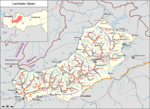
The Grubigstein is located in Tyrol on the eastern edge of the Lechtal Alps , a mountain group of the Northern Limestone Alps , and represents a rugged three-peaked upswing at the end of the Gartnerwand east ridge. The summit is about 6 km (as the crow flies ) southwest of Ehrwald and immediately southwest of Lermoos or west of Biberwier . Despite its low independence with regard to the geographical parameters dominance and prominence , its perspective-related optical independence is great, especially from Lermoos.
The 3168 m long Lermoos tunnel , a section of the Fernpassstraße (B179), runs through the northeast and east side of the valley foot . In the southwest, the Grubigstein towers over the headwaters of the Loisach , in the south the Fernpass .
tourism
The Lermoos ski area is located on the northeast and eastern flanks of the Grubigsteins. The private Grubighütte ( 2028 m above sea level ) can be reached by cable car on a rocky step below the summit . The German Alpine Association operates the Wolfratshauser Hut ( 1753 m above sea level ) on a grass ridge that tapers to the north .
outlook
The summit cross offers a beautiful view of the Zugspitze and the Mieming Mountains , and when the visibility is good you can also see parts of the Karwendel and the Stubai Alps .
Web links
Individual evidence
- ↑ Geological map of Bavaria with explanations (1: 500,000). Bavarian Geological State Office, 1998.


