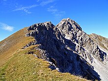
Loreak's head
| Loreak's head | ||
|---|---|---|
|
Loreakopf with Loreascharte (west side) |
||
| height | 2471 m above sea level A. | |
| location | Tyrol , Austria | |
| Mountains | Lechtal Alps | |
| Dominance | 5.2 km → Heiterwand | |
| Notch height | 907 m ↓ Schweinsteinjoch | |
| Coordinates | 47 ° 21 '14 " N , 10 ° 46' 17" E | |
|
|
||
| rock | Main dolomite | |
| Age of the rock | Upper Carnium - Norium | |
| Normal way | Fernstein - Loreahütte - Loreascharte -Loreakopf | |
The Loreakopf is a 2471 m above sea level. A. high mountain in the Lechtal Alps in the Austrian state of Tyrol .
Surname
The name Lorea is derived from the Rhaeto-Romanic "Luraria" and means 'funnel'. In addition to the name Loreakopf , the name Loreaspitze is also used for this mountain.
location
Within the Lechtal Alps, the Loreakopf is located on the eastern edge of this mountain group, directly above the Fernpass . To the north, the Loreakopf sends a four-kilometer-long mountain ridge that ends at the summit of the Red Stone . In the south lies the Heiterwand mountain range . The most important valley locations at the foot of the mountain are Fernstein am Fernpass in the east and the Berwang district of Mitteregg in the north-west .
history
Since the summit is relatively easy to reach for the experienced, the first ascent should have been made early by local shepherds and hunters. The first documented ascent was carried out by Karl Sander from Saxony on behalf of the geognostic-mining association for Tyrol and Vorarlberg , which had set itself the goal of geological exploration. Sander reached the summit on August 19, 1840 via the Lorea-Alpe and the southern ridge, which roughly corresponds to today's normal route. The oldest report on a tourist ascent comes from the Memmingen mountaineer Anton Spiehler . Spiehler climbed the Loreakopf on August 15, 1883 together with the chamois hunter Sprenger from Mitteregg. Sprenger had previously climbed the Loreakopf over the north flank through the Wildkar and was therefore selected by Spiehler as a local guide.
Routes to the summit
The normal route , which requires surefootedness and a head for heights, leads from the Fernpass over the uncultivated Loreahütte to the Loreascharte . From there you can reach the summit via the south ridge. Individual climbing points in the ascent are rated with difficulty level I (UIAA). From the north-west, the Loreakopf can also be reached from Mitteregg via the Loregghütte and from there on to the Loreascharte.
Summit panorama
Literature and map
- Dieter Seibert: Alpine Club Guide alpine - Lechtal Alps . 2nd Edition. Bergverlag Rother , Munich 2008, ISBN 978-3-7633-1268-9
- Alpine Club Map 1: 25,000, sheet 4/1, Wetterstein-Mieminger Gebirge, Westblatt
Web links
Individual evidence
- ^ Federal Office for Metrology and Surveying Austria: Austrian Map online (Austrian map 1: 50,000) . Retrieved September 30, 2012.
- ↑ Compass map no. 4 Füssen-Ausserfern , Kompass-Karten GmbH, Rum / Innsbruck Austria
- ↑ Karl Bünsch: The mountains of Loreagruppe and their Ersteigungsgeschichte , journal of the German and Austrian Alpine Association, Volume 61, born in 1930, Innsbruck, starting on page 143, view the Digital Archive of the Austrian National Library
- ^ Anton Spiehler: Die Lechthaler Alpen , magazine of the German and Austrian Alpine Association, Volume 19, year 1888, published by the German and Austrian Alpine Association in Munich, from page 235
- ^ Heinz Groth: Alpine Club Guide Lechtal Alps . 3. Edition. Bergverlag Rother, Munich 1981, ISBN 3-7633-1224-2 , from page 505


