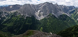
Heiterwand
| Heiterwand | ||
|---|---|---|
|
North side of the Heiterwand (left the east summit, middle right the main summit) |
||
| height | 2639 m above sea level A. | |
| location | Tyrol , Austria | |
| Mountains | Lechtal Alps | |
| Dominance | 6.1 km → Hintere Platteinspitze | |
| Notch height | 745 m ↓ Hahntennjoch | |
| Coordinates | 47 ° 18 '50 " N , 10 ° 43' 58" E | |
|
|
||
| rock | Wetterstein lime | |
| Age of the rock | Triad | |
| First ascent | 1890 Shepherd J. Kolb | |
| Normal way | South wall ( II ) | |
| particularities | Longest wall in the Northern Limestone Alps | |
The Heiterwand is a 7.5 km long, closed rock face in the Lechtal Alps , Tyrol , Austria with numerous peaks.
construction
According to the Alpine Club Leader, the Heiterwand is the longest closed wall in the Northern Limestone Alps and never falls below a minimum height of 2,400 m . The wall runs in a west-east direction, to the north and south it presents closed walls. In the west the Steinjöchl, 2198 m , connects with the Falschkogel, in the north the Kromsattel, 2120 m , and the Hinterbergjoch, 2210 m , with the neighboring elevations Tschachaun and Hinterberg ( 2303 m ) to the north . In the south, the Kratzersattel, 2130 m , separates from the Kienberg, 2204 m , and the Grubegg Joch, 2010 m , from the Schafkopf, 2490 m . The Grubeggjoch at the southeastern corner of the Heiterwand is the location of the Heiterwandhütte , to the west is the Kromsee, north of the Steinjöchl and west of the Kromsattel is the Anhalter Hütte . According to its structure, the Heiterwand has numerous peaks, from west to east the most important are:
- Maldongrat, 2544 m above sea level A.
- Gabelspitze, 2581 m above sea level A.
- Alpeilspitzen, 2552 m above sea level. A.
- Tarrentonspitze, 2608 m above sea level A.
- Main summit, 2639 m above sea level A.
- East summit, 2471 m above sea level A.
First ascent
Main summit through the southern flank: Kolb, 1890, Maldongrat 1875 through Vögele and Lechleitner.
Tour possibilities
The Heiterwand area is easily accessible through the nearby Hahntennjoch and the two Alpine Club huts Anhalter Hütte and Heiterwandhütte .
The Heiterwand can be circled on paths and climbs. The northern part corresponds to the connecting route Anhalter Hütte - Heiterwandhütte via the Hintere Tarrenton-Alpe and Reisenschuhtal, 5 hours. The southern part of the circuit runs on the former Heiterwandweg, 5 hours. This path should be in disrepair, but still be findable. The alpine club guide mentions “indestructible strength, instinctive orientation, climbing skills, absolute surefootedness, a head for heights - and humor” as the prerequisites for the ascent. Inexperienced people should only undertake this part of the trail in the company of experienced mountain hikers or guides.
The Heiterwand can be climbed over its entire length. The entire crossing takes 8 to 16 hours, it can be done in sections (with descents to the nearby huts for the night). Difficulty level mostly II to III, some sections IV.
Further climbs:
- Maldongrat, 2552 m , marked trail from Steinjöchl, later climbing I, a good 1 hour from Steinjöchl
- Main summit, 2638 m , through the south face, difficulty level II, 2.5 hours
- East summit, 2461 m , east ridge, difficulty level II, 2.5 hours
- Numerous climbing routes, difficulties from II (few climbs), mostly III to VIII lead through the north and south walls.
literature
- Heinz Groth: Alpine Club Leader Lechtal Alps . Bergverlag Rother , Munich
Web links
Individual evidence
- ↑ a b c d e f g Federal Office for Metrology and Surveying Austria: Austrian Map online (Austrian map 1: 50,000)
- ^ Geological map of Austria 1: 50,000 , Federal Geological Institute 2009, sheet 115 Reutte

