Valluga
| Valluga | ||
|---|---|---|
|
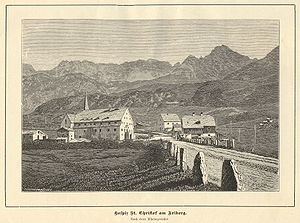
Historical view of St. Christoph in front of the pass, with Valluga in the background (1889) |
||
| height | 2809 m above sea level A. | |
| location | Tyrol and Vorarlberg , Austria | |
| Mountains | Lechtal Alps | |
| Dominance | 8.8 km → Vordere Rendlspitze | |
| Notch height | 579 m ↓ Almajurjoch | |
| Coordinates | 47 ° 9 '27 " N , 10 ° 12' 47" E | |
|
|
||
| First ascent | September 6, 1877 by Andreas Madlener from the Schindlerspitze (tourist) | |
| particularities | The mountain lies on the European watershed between the Danube and the Rhine | |
The Valluga (also Valfaggar , derived from the Rhaeto-Romanic Val vaccaria , German Kuhtal ) is a 2809 meter high mountain in the western Lechtal Alps and the highest peak in the Arlberg area on the border between the Austrian states of Tyrol and Vorarlberg . Was first climbed the Valluga on 6 September 1877 by the Bregenz mountaineers and chairman of DÖAV - section Vorarlberg, Andreas Madlener, alone.
Location and surroundings
The mountain is three and a half kilometers as the crow flies north of the winter sports resort St. Christoph am Arlberg . Neighboring peaks in the west are the Pazielfernerspitzen (2712 m), the Pazielspitze (2770 m) and in the north, separated by the southern Pazieljoch (2495 m), the Roggspitze with 2747 meters. In the southeast is the 2660 meter high Jahnturm . To the west of the Valluga is the Pazielferner , a small glacier below the Trittscharte, the size of which has decreased significantly in recent decades due to increasing global warming . An even smaller ice field (remnants of the earlier Vallugaferner) exists just above the Vallugagrat station of the Vallugabahn . The European watershed between the Danube and the Rhine runs across the ridge south of the summit.
Bases and tours
Madlener's path in September 1877 led from St. Christoph am Arlberg first to the Schindlerspitze, then over the Schindlerferner and then over the south side to the summit of the Valluga. The descent led in a south-westerly direction over the upper Pazieler Ferner to the summit of the Trittkopf and further down to the Flexenpass .
The Ulmer Hut on the southern flank of the mountain at an altitude of 2279 meters and the Stuttgarter Hut to the north (2305 m) serve as today's bases for ascent of the Valluga and for ski tours . From the Ulmer Hütte the normal route , the easiest ascent, leads in a north-easterly direction up to the Valfagehrjoch (2539 m) and from there north, then west to the Vallugagrat cable car station (2646 m). The Valluga summit can be reached in two hours via the south ridge . The mountain is also accessible via mountain railways from St. Anton am Arlberg and Galzig .
Winter sports
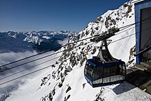
The large Ski Arlberg ski area extends around the Valluga . 88 lifts and cable cars open up 350 kilometers of slopes for downhill skiing. The Valluga is technically accessible from two aerial tramways (two sections). A slope is served from the Vallugabahn I mountain station, which branches off to a short connecting lift. At its mountain station you can either go to St. Anton or further to Stuben or to Warth.
The Vallugabahn II leads to the summit, where there is a viewing platform. In principle, this area is not suitable for skiing, but is still the starting point for many tourers.
Infrastructure
The Vallugabahn takes you to the summit of the Valluga in two cable car routes.
At the summit of Valluga is a C-band - weather radar of Austro Control , the data on the state warning center are available Vorarlberg.
The ZAMG weather radar, which was put into operation on the Valluga in October 2007 , now allows a comprehensive observation of Vorarlberg, which until then was only incomplete due to the detection with German and Swiss rain radars and a system on the Patscherkofel . Due to its very exposed position, it has a range of 220 km, but has been hit and paralyzed several times by lightning. It took several days to weeks for the spare parts to arrive from the USA.
According to those on the Hinterer Brunnenkogel , the Sonnblick and the Pitztal Glacier , the Valluga carries the fourth highest mountain weather station of the ZAMG, with which other values (temperature, wind speed, humidity etc.) are permanently recorded and made available to the public via the Internet be asked.
Also located on the Valluga infrastructure for the Amateur Radio: a 2-meter - relay station (enter 145.6875 MHz, 145.0875 MHz output) and a Digipeater for Packet Radio . These two have the common amateur radio call sign OE7XVR. Between 2004 and 2010 there was also a relay station for amateur radio television (callsign OE7XSI) with interlinks to other relay stations in Austria, Switzerland and Germany.
Literature and map
- Dieter Seibert: Alpine Club Guide Lechtaler Alpen , Bergverlag Rother , Munich 2008, ISBN 978-3-7633-1268-9
- Alpine club map 1: 25,000, sheet 3/2, Lechtal Alps, Arlberg area
Individual evidence
- ↑ Communications of the German and Austrian Alpine Club , Volume IV, Munich 1878, p. 88
- ↑ Dieter Seibert: Alpenvereinsführer Lechtaler Alpen , Munich 2008, p. 276 f., RZ 1085 ff.
- ↑ H. Paulitsch, F. Teschl and WL Randeu: Dual-polarization C-band weather radar algorithms for rain rate estimation and hydrometeor classification in an alpine region , Advances in Geosciences, 20, 3–8, 2009.
- ↑ Website of the weather radar ( Memento of the original from May 18, 2011 in the Internet Archive ) Info: The archive link was inserted automatically and has not yet been checked. Please check the original and archive link according to the instructions and then remove this notice.
- ↑ Valluga weather radar station: more precise forecast possible. Retrieved February 13, 2020 .
- ↑ Weather radar NEW on VOL! Retrieved February 13, 2020 .
- ↑ Marlies Mohr: No spare parts for breakdown radar on the Valluga. Retrieved February 13, 2020 .
- ↑ Weather radar back in operation from Tuesday - oesterreich.ORF.at. Retrieved February 13, 2020 .
- ↑ Mountain stations - ZAMG. Retrieved February 14, 2020 .
- ↑ ÖVSV: Amateur radio repeaters in Austria ( Memento of the original from January 15, 2015 in the Internet Archive ) Info: The archive link was inserted automatically and has not yet been checked. Please check the original and archive link according to the instructions and then remove this notice. As of January 8, 2015, accessed on January 15, 2015.
- ↑ ÖVSV: User frequencies of Digis & BBS in OE ( Memento of the original from March 4, 2016 in the Internet Archive ) Info: The archive link was inserted automatically and has not yet been checked. Please check the original and archive link according to the instructions and then remove this notice. As of August 2012, accessed on January 15, 2015.
- ↑ ÖVSV: OE7XVR ATV-Relais Valluga , status November 22, 2014, accessed on January 15, 2015.


