
St. Leonhard in the Pitztal
|
St. Leonhard in the Pitztal
|
||
|---|---|---|
| coat of arms | Austria map | |
 |
|
|
| Basic data | ||
| Country: | Austria | |
| State : | Tyrol | |
| Political District : | Imst | |
| License plate : | IN THE | |
| Surface: | 223.44 km² | |
| Coordinates : | 47 ° 4 ' N , 10 ° 51' E | |
| Height : | 1366 m above sea level A. | |
| Residents : | 1,384 (January 1, 2020) | |
| Population density : | 6.2 inhabitants per km² | |
| Postal code : | 6481 | |
| Area code : | 05413 | |
| Community code : | 7 02 17 | |
| NUTS region | AT334 | |
| Address of the municipal administration: |
No. 115 6481 St. Leonhard im Pitztal |
|
| Website: | ||
| politics | ||
| Mayor : | Elmar Haid (ÖVP - unified list of farmers, tradespeople and workers and employees) | |
|
Municipal Council : (2016) (13 members) |
||
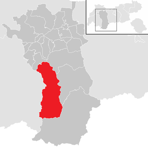
| Location of St. Leonhard im Pitztal in the Imst district | ||
  |
||
| Source: Municipal data from Statistics Austria | ||

St. Leonhard im Pitztal is an Austrian municipality with 1,384 inhabitants (as of January 1, 2020) in the Imst district in Tyrol .
geography
Geographical location
St. Leonhard is located in the inner Pitztal , on the narrow bottom of which hamlets and villages are scattered over a length of about 25 kilometers. Along with Sölden in the Ötztal and Neustift in the Stubai Valley, the municipality is one of the largest in area in Tyrol. The highest point in the municipality is the 3768 m high Wildspitze , with the main summit just outside the municipality.
In the outer municipality area there are some hamlets and farmsteads also on extreme slopes, in the middle and inner part almost exclusively in the valley floor area or on murk cones. Due to the altitude, the north-south orientation of the inner valley and the steep mountain slopes, the climate is rather harsh, the vegetation period usually only lasts four months.
Community structure
The municipality includes the following three localities (population in brackets as of January 1, 2020):
- Plangeross (244)
- St. Leonhard im Pitztal (738)
- Fence yard (402)
The community consists of the Pitztal cadastral community .
|
structure
|
||||||
|
Legend for the breakdown table
|
Localities
Zaunhof ( 1291 m )
The northernmost fraction extends with several districts mainly on the eastern slope of the central Pitztal.
The districts are Ausserlehn, Boden, Burg, Egghof, Enzenstall, Grüble, Grün, Hairlach, Moosbrücke, Oberlehn, Obermühl, Pfurmühl, Rauchbichl, Rehwald, Schußlehn, Wiese and Zaunhof.
Due to economic hardship, as in the entire Innerpitztal, the residents were forced to work seasonally, and some left their homeland forever, for example to the Rhineland or to Fehrbach near Pirmasens .
In 1775 Zaunhof got its own church, as the way to St. Leonhard was dangerous in winter due to avalanches .
Before the First World War , Zaunhof was known for its saw sharpeners, lumberjacks and carpenters. Today the district is a starting point for hikes and mountain tours in the area.
St. Leonhard ( 1366 m )

St. Leonhard ("the middle church") is the central fraction of the municipality.
Districts are Auhof, Bichl, Biedern, Eggenstall, Enger, Froschputzen, Gschwandt, Köfels, Neurur, Piösmes, Scheibe, Scheibrand, Schweighof, Stillebach, Trenkwald, Unterrain, Wald, Weixmannstall, Schrofen and Wiese.
St. Leonhard became a curate in 1646 and an independent parish in 1891. The eponymous parish church is consecrated to the abbot Leonhard von Limoges in central France, who lived in the 6th century . He is particularly popular in Austria, Bavaria and Swabia as a popular saint. The church was consecrated in 1778, but dates back to an older church from the 17th century that was rebuilt or rebuilt. The figures of St. Peter and James at the high altar were created around 1767 by Josef Georg Witwer from Imst.
The place name Piösmes goes back to an unknown pre-Roman population. In Neurur and Plangeross, farmers in Arzler had alpine pastures for a long time , when around 1300 the mighty lords of Starkenberg built two Schwaighöfe , where the two hamlets are today. In the last few decades Neurur has developed from a rural settlement to a tourist destination.
Plangeross ( 1617 m )

The place name (previous spelling with ß) comes from pre-Germanic times, but its origin and meaning are unclear.
The Lords of Starkenberg built a Schwaighof around 1300 in Plangeross. With increasing population pressure, it was divided several times. A modest silver ore mining facility temporarily contributed to the livelihood of the population. A first upswing took place in the 19th century with the advent of tourism, which received a strong boost from the completion of the road to Plangeross in 1956 and significantly shaped the townscape.
From Plangeross you climb in a westerly direction to the Kaunergrathütte . The approach to the Rüsselsheimer Hütte begins in an easterly direction at the parking lot just below Plangeross.
Mandarfen ( 1682 m )

The name Mandarfens is probably derived from mons arboris , which means something like "Baumberg", "Zirbelbaumberg", and was first mentioned in 1288. Even before the Second World War , the district developed from what was once two farmhouses into a summer and winter tourist destination. With the construction of the Rifflsee-Bahnen and the Pitztaler Gletscherbahn , Mandarfen became a mountain sports center.
Mittelberg ( 1736 m )
Mittelberg lies at the head of the valley at the foot of the 3,162 m high Mittagskogel and forms the last permanent settlement and the end of the bus route. In comparison to the rest of the Innerpitztal, Mittelberg has better sunshine duration.
Between Mandarfen and Mittelberg, at the Hotel Gletscherblick and Hotel Anger Alm , the Taschachbach from the Taschach Valley joins the Mittelbergerbach to the Pitze (sometimes the Mittelbergerbach is also shown as the Pitze). Part of the water is contained there and fed to the Gepatsch reservoir in the Kaunertal .
Rifflsee ( 2232 m )
The Rifflsee is the largest lake in the Ötztal Alps . The 27- hectare lake is a typical moraine reservoir and can be reached from Mandarfen with the Rifflsee-Bahn (6-seater gondola lift), which goes from about 1600 m to 2300 m . The Rifflsee area serves both as a winter ski area and as a hiking area in summer. The highest point in the Rifflsee ski area is the 2800 m high pit head.
Neighboring communities
history
The community of St. Leonhard im Pitztal consists of numerous villages, hamlets and scattered settlements . The settlements mostly emerged from Schweighöfen belonging to the owners of the Starkenberger , Hirschberger or Stams monastery at the time . The princely hunt also led to the settlement of their retinues in the Pitztal, as evidenced by the establishment of the village of Neurur. The place St. Leonhard itself has been part of the Imst court since records began , but is only mentioned in a document in 1300, together with "Planchenroß" (Plangeross) and "Niwenrur" (Neurur). Schrofen was previously mentioned in a document in 1265, later also "Piesins" (Piösmes) 1313. In the penal letter of 1485 St. Leonhard is called "Sand Leonharden im Putzental". The very same letter granted the residents of St. Leonhard their own chaplain, as previously care was only given by an assistant priest from the Imst parish in the then very remote areas of the Pitztal. The oldest baptismal register of the curate in St. Leonhard dates from 1646, around 1750 a curate of its own was set up in Plangeross, and in 1773 Zaunhof received a beneficiary .
In the 19th century there were four brotherhoods in St. Leonhard , including the Franz Xaver brotherhood founded in 1744. In 1891 it was raised to the status of an independent parish of St. Leonhard.
In 1935 the municipality of Pitztal was renamed St. Leonhard im Pitztal . As in many other municipalities in Tyrol, tourism developed into a major economic factor in the 20th century.
politics
The last municipal council election took place on February 28, 2016. 1,159 people were entitled to vote. The turnout was 79.55% (cf. 2004 86.30%; 2010 75.77%)
Distribution of votes 2016:
- ÖVP - single list of farmers, tradespeople and workers and employees - 43.95%
- One Church - One List - 27.08%
- Zaunhof standard list - "ACTIVE for EVERYONE" - 11.88%
- ACTIVE for St. Leonhard - Shaping the economy and the future with competence and experience - 6.99%
- FPÖ - Freedom and free list for St. Leonhard - 10.10%
Mayor Elmar Haid ("ÖVP - Unified List of Farmers, Tradespeople and Workers and Employees").
- 2016: 799 votes (100%)
- 2010: 674 votes (80.91%)
- 2004: 558 votes (61.79%)
coat of arms
Blazon : On a shield split by silver and red, two turned away ibex heads in mixed up colors.
The two ibex heads in the coat of arms refer to the importance of the community of St. Leonhard as a habitat for these magnificent animals in the past and present. The Tyrolean state colors white and red represent the local state hunting.
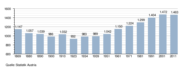
Population development
Culture and sights
See also: List of listed objects in St. Leonhard im Pitztal
- Parish church of St. Leonhard in the Pitztal
- Parish church Plangeross
- Expositurkirche Zaunhof
- Pilgrimage church hl. Maria am Bichele
Pitztaler Gletscherbahn


In December 1983, with the opening of the “Pitzexpress” glacier lift, the Pitztal Glacier ski area on the Mittelbergferner was opened up for tourism . The train, designed as a funicular in a tunnel (tunnel), begins at Mittelberg in 1720 and leads to the mountain station at 2840 meters above sea level. The maximum speed is 12 m / s (43 km / h) and the average travel time is eight minutes. After the fire disaster on the Kaprun 2 glacier lift , the safety measures were extensively expanded: the tunnel was completely illuminated, a smoke gas alarm system was installed in the train and, among other things, video surveillance was installed for the passenger areas.
Several lifts connect to the mountain station of the Stollenbahn, including the Wildspitzbahn from 2,840 to 3428 m to the Hinteren Brunnenkogel , the highest cable car in Austria. Skiing is offered there from mid-September to early June each year. The area also has a high altitude cross-country ski run in the altitude range of around 2600 m and a length of up to six kilometers.
The development of the glacier world for tourism has been criticized by nature conservationists and alpine associations, but it offers an important livelihood for the residents of the Pitztal and prevented emigration. However, the construction of a safety path on the Mittelbergferner in 2006 resulted in massive, visible interventions in the sensitive high alpine glacier landscape.
Personalities
- Simon Breitfuss Kammerlander (* 1992), ski racer starting for Bolivia
- Leonhard Jennewein (1682–1754), master builder, born in St. Leonhard
- Louis Zotz (1903–1989), theologian and university founder in the Philippines, died in Zaunhof.
Web links
- 70217 - St. Leonhard im Pitztal. Community data, Statistics Austria .
Individual evidence
- ↑ The official spelling is specified or shown in the list of Tyrolean municipalities in the appendix to the Tyrolean municipal code 2001; accessed on April 11, 2012 and on Statistics Austria: A look at the community
- ↑ Statistics Austria: Population on January 1st, 2020 by locality (area status on January 1st, 2020) , ( CSV )
- ↑ a b St. Leonhard im Pitztal-Tirol (= Christian Art Places Austria . No. 365), page 2, Verlag St. Peter, Salzburg 2001
- ↑ a b Chronicle of the community of St. Leonhard im Pitztal, viewed on November 4, 2015
- ^ State law and ordinance sheet for Tyrol, No. 45/1935
- ↑ https://wahlen.tirol.gv.at/gemeinderats_und_buergermeisterwahlen_2016/gemeinden/st_leonhard_im_pitztal.html
- ↑ a b https://wahlen.tirol.gv.at/gemeinderats_und_buergermeisterwahlen_2016/gemeinden/st_leonhard_im_pitztal.html
- ↑ Archived copy ( memento of the original dated November 6, 2012 in the Internet Archive ) Info: The archive link was inserted automatically and has not yet been checked. Please check the original and archive link according to the instructions and then remove this notice.
Arzl im Pitztal | Haiming | Imst | Imsterberg | Jerzens | Karres | Karrösten | Längenfeld | Mieming | Mils at Imst | Mötz | Nassereith | Obsteig | Oetz | Rietz | Roppen | St. Leonhard im Pitztal | Sautens | Silz | Sölden | Stams | Tarrenz | Umhausen | If it