Taschachferner
| Taschachferner | ||
|---|---|---|
|
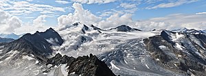
Taschachferner and Wildspitze (3768 m) seen from the Hinterer Brunnenkogel (3440 m) |
||
| location | Tyrol , Austria | |
| Mountains | Ötztal Alps | |
| Type | Valley glacier | |
| length | 5.3 km (2011) | |
| surface | 5.71 km² (2006, only to the east) | |
| Exposure | North nutrient area; Consumption area northwest | |
| Altitude range | 3760 m - 2240 m (1975) | |
| Coordinates | 46 ° 54 '7 " N , 10 ° 50' 11" E | |
|
|
||
| drainage | Taschachbach (also transfer tunnel to the Gepatsch reservoir ) → Pitze → Inn | |
The Taschachferner is a glacier in the Ötztal Alps in the Austrian state of Tyrol . It is located at the end of the Pitztal north of the Wildspitze ( 3768 m ), the highest mountain in North Tyrol .
expansion
The glacier consists of two parts: a larger, eastern part north of the Wildspitze and a western part that breaks up into many smaller fragments. In the upper area, the Petersenspitze ( 3472 m ) and its northeast ridge form the dividing line between the two areas. Towards the end of the 20th century, the eastern and western Taschachferner lost contact due to the retreat of the glaciers . A glacial lake has formed at the end of the tongue of the eastern Taschachferner since 2003 .
The nutrient area of the eastern Taschachferner is framed by the Schuchtkogel ( 3471 m ), Wildspitze, Hinterem Brochkogel ( 3628 m ) and Petersenspitze. The total area of the eastern Taschachferner was given in 2006 as 5.71 km². The glacier tongue ends at an altitude of approx. 2200 m, near the Taschachhaus , an alpine club hut . Since 1970 the glacier tongue has retreated by over 250 m. Of this, 104 meters were accounted for in the 2004/2005 measurement period alone, which is a record among the Eastern Alps glaciers, caused by the tearing off of the glacier tongue at the lower valley step. The former lowest icefall, which is still shown on many maps, has now almost completely melted away.
Events
During the Second World War, an American Boeing B-17 bomber crashed over the Taschachferner; the wreckage has been uncovered for several years by the melting of the glacier below the Taschachferner Abbruch, not far from the Taschachhaus.
On September 13, 1962, five officers were buried by an ice avalanche during an exercise as part of the so -called Alpine Gendarmerie Service on the Taschachferner. The exercise leader, Gendarmeriebergführer Oberstleutnant Friedrich Rainer and the two participants in the exercise, Gendarmerie alpinist Raimund Ertl and Gendarmeriebergführer Anton Kendlbacher, are killed.
Literature and map
- Glacier report 2004/2005 of the PES glacier measuring service
- Alpine Club magazine Bergauf , issue 2-06
- Alpine club map sheet 30/2, 1: 25,000, Ötztal Alps, Weißkugel , ISBN 3-928777-39-4
Web links
- swisseduc.ch: Taschachferner
Individual evidence
- ↑ a b WGMS: Fluctuations of Glaciers Database. World Glacier Monitoring Service, Zurich 2012 ( DOI: 10.5904 / wgms-fog-2012-11 ), accessed on February 7, 2013
- ↑ a b M. Mergili: Compilation of the changes in length of the Austrian glaciers 1970–2013. ( online ( Memento of the original from January 27, 2016 in the Internet Archive ) Info: The archive link has been inserted automatically and has not yet been checked. Please check the original and archive link according to the instructions and then remove this note. ). Based on: Austrian Alpine Association: Glacier Reports. Collective reports on the glacier measurements of the Austrian Alpine Club from 1971 to 2011. Compiled by H. Kinzl, G. Patzelt, A. Fischer. In: Messages from the Austrian Alpine Club / Uphill. Volume 27-67. Retrieved April 30, 2013
- ^ J. Abermann et al .: Quantifying changes and trends in glacier area and volume in the Austrian Ötztal Alps (1969-1997-2006). In: The Cryosphere . Volume 3, 2009, pp. 205–215 ( online )
- ↑ swisseduc.ch: Taschachferner. Retrieved May 1, 2013


