
Petersenspitze
| Petersenspitze | ||
|---|---|---|
 Petersenspitze over Taschachferner and Taschachhaus (2,434 m) |
||
| height | 3472 m | |
| location | Tyrol , Austria | |
| Mountains | Weißkamm , Ötztal Alps | |
| Dominance | 0.5 km → Hinterer Brochkogel | |
| Notch height | 61 m ↓ Brochkogeljoch | |
| Coordinates | 46 ° 53 '19 " N , 10 ° 50' 22" E | |
|
||
| First ascent | July 26, 1874 | |

The Petersenspitze is a 3,472 meter high mountain peak of the Weißkamm in the Ötztal Alps in the Austrian state of Tyrol . It has a firn-covered knoll and is popular with mountaineers as a demanding high-tour destination due to its north and north-west face. The tip is named after the chemist Theodor Petersen , who was chairman of the Frankfurt am Main section of the German Alpine Club between 1869 and 1894 . In the years from 1871 to 1893, Petersen achieved several first ascents in the Ötztal Alps. The summit was first reached on July 26, 1874 by Moritz von Déchy from Budapest, Victor Hecht from Prague, and the mountain guides Johann Pinggera and Josef Spechtenhauser as they crossed the Wildspitze into the Pitztal.
Location and surroundings
The Petersenspitze is located in the Weißkamm, a mountain range about 20 km long that runs from southwest to northeast. It sends pronounced ridges to the northeast, south and west, which are mostly covered by glaciers . In the north the Taschachferner stretches up to the summit, in the south lies the Großer Vernagtferner . Neighboring mountains are along the south ridge in the southeast, separated by the Brochkogeljoch (3423 m), the Hintere Brochkogel with 3625 meters height, in the west, separated by the Taschachjoch (3236 m), the 3400 meter high Hochvernagtwand and in the northeast lies in the ridge the Taschachwand with 3354 meters. The next important place is Vent, a good five kilometers to the south-east as the crow flies .
Tourist development
The path of the group around Victor Hecht and Moritz von Déchy on July 26, 1874 led from the Wildspitze over the Brochkogeljoch and over the south ridge to the summit, after which one descended into the Pitztal. The route from Brochkogeljoch is still the normal route today , the easiest ascent to the Petersenspitze. The Vernagthütte located at 2755 meters above sea level can serve as a base . According to the literature, the walking time is three hours and leads first over the Vernagtferner to the yoke and then over the south ridge to the summit. A combined difficult route, ice up to 60 ° incline and rock of difficulty UIAA II leads through the northwest flank. The 150 meter high north face with an ice slope of up to 50 ° can be reached from the Taschachhaus (2434 m) to the north . In 1940 Karl Prusik first climbed the Petersenspitze over the Taschach ice flank (ice slope up to 50 °, rock UIAA I).
Literature and map
- Walter Klier , Alpine Club Leader Ötztaler Alpen , Bergverlag Rother , Munich 2006, ISBN 3-7633-1123-8
- Alpine club map 1: 25,000, sheet 30/6 Ötztal Alps, Wildspitze
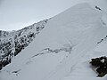
North face

North wall from below

In the north wall

Petersenspitze from the ascent to the Wildspitze


Web links
- Information on the ascent (English)
Individual evidence
- ^ Austrian Map online of the BEV
- ↑ www.oetztal.com: Hiking routes. Retrieved November 2, 2017 .
- ↑ Description on summitpost.org
- ↑ Tour description on bergdias.de
- ^ Journal of the German and Austrian Alpine Club : Year 1876, Munich, p. 225
- ↑ Walter Klier: Alpine Club Guide Ötztaler Alpen , Munich 2006, p. 315 f., Rz 2660 ff.