Vernagtferner
| Vernagtferner | ||
|---|---|---|
|
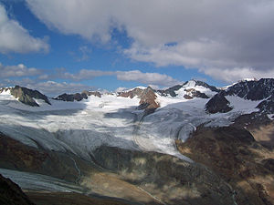
Vernagtferner from the south (2005), from Hintergrasleck |
||
| location | Tyrol , Austria | |
| Mountains | Ötztal Alps | |
| Type | Mountain glacier | |
| length | 2.6 km | |
| surface | 7.31 km² | |
| Exposure | Nutrient area: south; Consumption area: Southeast | |
| Altitude range | 3631 m above sea level A. - 2793 m above sea level A. | |
| Coordinates | 46 ° 52 ′ 0 ″ N , 10 ° 49 ′ 0 ″ E | |
|
|
||
| drainage | Vernagtbach , Rofenache , Venter Ache , Ötztaler Ache , Inn , Danube | |
The Vernagtferner [ fɐˈnaktˌfɛrnɐ ] is a glacier in the Ötztal Alps in Tyrol . It currently extends over an area of 7.31 km², making it one of the larger glaciers in the Eastern Alps . The glacier lies on the south side of the Weißkamm . The highest peaks in its catchment area are the Hochvernagtspitze and the Brochkogel . On many maps, the Vernagtferner is divided into small and large Vernagtferner , with the eastern part in the area of Brochkogel being referred to as Kleiner Vernagtferner . However, according to scientific criteria, these two sub-areas are not sufficiently independent to justify a separate designation.
The Vernagtferner is probably the best historically documented glacier in the Eastern Alps. The reason for this is the glacial lake eruptions it caused , which were feared in the Ötztal from the 16th to the 19th century . Today the Vernagtferner has withdrawn far from the Rofental and is particularly affected by the retreat of the glacier .
Position and shape

The Vernagtferner is located north above the Rofental , an extension of the Venter Valley , which in turn is a side valley of the Ötztal . It is located on the south side of the Weißkamm , a mountain range in the Ötztal Alps , just a little west of the Wildspitze , Tyrol's highest mountain. The Vernagtferner is framed by the Schwarzwandspitze , the Hochvernagtspitze , the Petersenspitze and the Vorderen and Hinteren Brochkogel , all of which are peaks of the Weißkamm . The Vernagtferner feeds the Vernagtbach , which flows into the Rofenache after a few kilometers . The Vernagtferner finally drains into the Black Sea via the Venter and Ötztaler Ache , the Inn and the Danube .
The shape of the Vernagtferner, which currently extends in an altitude range of 3631 to 2793 m , differs significantly from that of a typical alpine valley glacier , to which, for example, the neighboring Hintereis or Kesselwandferner correspond. A weitausladendes, several large, flat Karmulden composite Firngebiet , large slightly inclined south Verebnungen in the central region and a short and wide tongue along with two other small tongue ends characterize this glacier. Accordingly, the Vernagtferner is classified as a Firnmulden Glacier (English classification: compound basin ).
Scientifically, the glacier is divided into three areas from west to east, the Schwarzwand, Taschachjoch and Brochkogel areas. The Brochkogel area corresponds to the part designated on many maps as Kleiner Vernagtferner . In contrast, the sub-area between Schwarzkögele and Platteikogel, referred to as Klein-Vernagtferner in the map drawn up by Sebastian Finsterwalder in 1889, represented a tiny and isolated ice stream that drained through its own drain. At the time of the map, this small patch of firn was still fed by the Vernagtferner, but later separated from it completely. The Klein-Vernagtferner has disappeared since the 1970s . There is the assumption that this Klein-Vernagtferner documented by Finsterwalder was misinterpreted while working on the later map material and that this led to the current division. Contrary to the classification documented on the maps, the western of the three areas, the black wall area, is most clearly separated from the rest of the glacier.
history

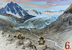
The Vernagtferner and the neighboring Hintereisferner are among the earliest explored glaciers on earth. The reason for this is that the then wildly torn Vernagtferner reached the Rofener Tal, accumulated on the opposite rock face, the Zwerchwand, and thus blocked off the Rofener Ache with an icy dam. A reservoir of up to 1.5 km in length, the Rofener Eissee , formed behind this ice dam . Most of the time it ran smoothly over the top of the dam during the snowmelt, but sometimes the water paved a way under the ice, widened it and finally burst the ice dam, so that in a very short time an icy tidal wave devastated the Venter and Ötztal and even that Inntal flooded.
The illustration shows a contemporary representation of the Rofener Eisseee. It is the oldest known representation of an alpine glacier. It was created during an investigation that was carried out at the instigation of the Tyrolean authorities in July 1601, “so that the Ötztal and above all the Inn Valley would not suffer any damage” . The dammed Rofener Eissee is reproduced as it appeared at that time with a lake level height of 2260 m . It extended over 1.7 × 0.4 km and had a volume of eleven million cubic meters. The picture shows the landscape rather fancifully, but some details, such as the icebergs floating on the lake , are reproduced correctly.
The abovementioned sudden outbreaks of the ice lake are well documented mainly on the basis of the records in the Längenfeld community chronicle, for the first time for the years 1600/1601 and described by the Innsbruck building scribe Abraham Jäger. Further outbreaks of catastrophic proportions occurred in 1678 and 1680. They also caused crop failures and thus numerous starvation victims. The desperation and powerlessness also led to a bitter witch hunt, to which more people fell victim. There were further series of eruptions in 1775, 1778 and 1780 and the last time in 1845, 1846 and 1848, with the eruption of 1845 again causing very severe damage.
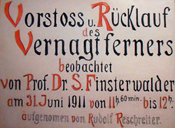
Such catastrophes also led to the glaciers in the Ötztal being given special attention very early on, long before scientific research into glaciers began . A year after the eruption of 1771, Joseph Walcher , mechanics teacher and mathematics professor in Vienna, visited the Vernagtferner and wrote the first scientific treatise on the Ötztal glaciers with the "News from the Icebergs in Tyrol" (1773). In it he also wrote what to do in which order in the event of imminent danger: "Pray, clear the stream, remove the wood from the bank." In the years that followed, the Ötztal glaciers and especially the Vernagtferner were instrumental in gaining new fundamental knowledge Glacier science involved. The works of Sebastian Finsterwalder , who was a professor at the Technical University in Munich and dedicated himself to glacier research, from around 1895 are regarded as standard works for the technique of glacier surveying . These works contain ideas about the laws of glacier movement that are still valid today.
The last major advance of the Vernagtferner took place from 1897 to 1902. Although it no longer reached the Rofental, the flow speed of the ice increased dramatically during this time from around 20 to almost 300 meters per year.
Research on Vernagtferner has been under the patronage of the Commission for Glaciology of the Bavarian Academy of Sciences (KfG of BAdW) in Munich since 1965 . With the establishment of a discharge measuring point on the Vernagtbach and the construction of a water level station in 1973, research on the Vernagtferner was greatly expanded and, above all, questions of the water balance in glaciated catchment areas were intensively investigated. This includes measurements of wind strengths and directions, snow and rain amounts, humidity, temperature and radiation balances as well as camera recordings. The German Research Foundation with the Collaborative Research Center 81 between 1974 and 1986, the Technical University of Munich and the Institute for Radiohydrometry of the Society for Radiation and Environmental Research as well as the institutes of the University of Innsbruck and the Hydrographic Service of the State of Tyrol were involved in studies.
Current development
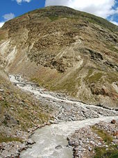
Today the Vernagtferner ends about 680 m above the Rofental and is more than four kilometers away from it. This means that the risk of the Rofenache being blocked by an ice dam has long been eliminated. However, the amount of water released by the glacier has increased significantly and the water release is also subject to greater fluctuations than before, which can also create dangerous tidal waves, as in the summers of 1987 and 1998. The main reason for this is that the glacier has almost all of its snow body which used to have a high storage capacity for melt water and thus dampened the runoff for days and weeks.
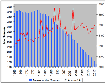
The diagrams on the right show data on the development of the Vernagtferner that have been collected by the BAdW Glaciology Commission since 1965. The upper diagram shows the area of the glacier, with the ablation and accumulation area ( nutrient and consumption area ) shown in different colors. The development of the total mass is shown in the diagram below. In addition, the altitude of the equilibrium line is noted there (ELA, Equilibrium Line Altitude ). This is the altitude at which the mass balance of the year under consideration is balanced. It separates the area of accumulation from the area of ablation.
After a weak growth phase in the mid-1970s, the glacier reached a short-term high in 1980, according to the glaciologist Oskar Reinwarth. The glacier has been steadily losing mass since the early 1980s. The last glacier-friendly summer with an almost balanced budget was in 1999. It can be seen that the glacier is currently losing less spectacularly in area, but mainly in ice thickness.
The summer of 2003 brought the Vernagtferner a loss of a magnitude that has not yet been observed since the beginning of scientific research. The reason for this were several factors: After a moderate amount of winter snow, the fumigation started very early. For the first time in the observation period, the ablation area (consumption area) extended over the entire surface of the glacier. Only a short fall of fresh snow interrupted the ablation period, which was twice as long as in the previous years of strongest losses in the 1990s. The extreme losses of 2003 continued to have an impact in 2004 and 2005. The weather in the summer of those years should actually have led to a balanced or even slightly positive mass budget, but this was not the case.
The weather in the summer of 2006 again led to a significant year of losses for the mass budget of the Vernagtferner. The fact that there was no new record was only due to the below-average cool and humid weather in August, because at the end of July the starting position was comparable to the situation at the same time in 2003.
In the summer of 2007 the Vernagtferner broke up into two independent parts. The western part, the Schwarzwand area, no longer has any connection to the eastern, much larger part in the area of the Taschachjoch and the Brochkogel.
forecast
According to the knowledge gained, the above-average losses of the Vernagtferner in recent years are not only due to a changed climate , but also to the special characteristics of the glacier. The fatal effect here is that it has lost most of the firn body required for the formation of new glacier ice . In order to build up the firn body again and "fan" the glacier movement again and thus bring about a new advance, a long period with a cool and humid climate would be required.
Without such a serious climate change in the next few decades, the Vernagtferner will continue to retreat to the high plateau, similar to the Schneeerner on the Zugspitze , disintegrating into partial areas and finally disappearing completely, leaving behind a barren moraine landscape .
The appearance in the glacier region will also change because the ice masses have so far supported the rock edge in the ridge layers and prevented the subsoil from thawing. The disappearance of the ice masses causes a loss of stability and considerable erosion phenomena , such as the collapse of an entire rock pillar near the Sexenjoch at the beginning of 1999. The famous rock fall on the Eiger in the summer of 2006 is also due to the same effect.
Alpinism

The alpinistic importance of the Vernagtferner is not outstanding, nevertheless, according to Richard Goedeke , the glacier is still "extensive and equipped with crevasses ". The starting point or end point of a tour over the Vernagtferner is typically the Vernagthütte . Probably the most frequently taken tour leads from there over the Brochkogeljoch to the Wildspitze ( 3770 m above sea level ). However, since this takes around 4½ hours and there are much shorter climbs to the Wildspitze today, this tour is also relatively rarely done.
Worth mentioning are the four-hour tour to the Hochvernagtspitze ( 3539 m above sea level ) and the transition over the Taschachjoch and the Taschachferner to the Taschachhaus , where you walk large parts of the Vernagtferner. In the summer season, however, it is usually quite lonely on the glacier. The Vernagtferner is a little more frequented during the ski tour season, as the tour to the Hochvernagtspitze is a popular ski tour .
Literature and maps
- Eduard Richter : On the history of the Vernagt glacier. Contributions to the history and geography of the Alps. IV.. In: Journal of the German Alpine Association / Journal of the German and (the) Austrian Alpine Association , year 1877, (Volume VIII), pp. 164–168. (Online at ANNO ). .
- Gernold Patzelt: Glacier research with tradition . In: Mountains. The international magazine of the mountain world , No. 26/1987, ZDB -ID 283675-0 , Wabern-Bern 1987.
- Ludwig Braun, Markus Weber: Glacier research on Vernagtferner (PDF; 418 kB); In: DAV Panorama. Announcements from the German Alpine Club. ; Issue 1/2001; Pp. 34-39.
- Ludwig Braun, Markus Weber: Glacier - water cycle and water donation . In: Alpine Spatial Planning. Technical articles by the Austrian Alpine Association , issue 27/2005, ZDB -ID 1064777-6 , pp. 41–46.
- Glacier research on Vernagtferner , Journal for Glacier Science and Glacial Geology (ZGG), Volume 45/46 (2011/12), online
- Alpine club map sheet 30/2, 1: 25,000, Ötztal Alps, Weißkugel, ISBN 3-928777-39-4 .
Web links
- Commission for Glaciology of the Bavarian Academy of Sciences (KfG of BAdW) .
- M. Weber, KfG of BAdW: Visualization of the future of the Vernagtferner in this century .
- Features section. From the Vernagt glacier. In: Innsbrucker Nachrichten , No. 243/1900 (XLVII. Volume), October 23, 1900, p. 1 ff. (Online at ANNO ). .
- Measurement data from the level station on Vernagtferner , archived in the data system PANGEA
- Ice-free: Interview with the glaciologist Dr. Ludwig Braun In: Energiewende-Magazin , September 20, 2017
Individual evidence
- ^ A b c World Glacier Monitoring Service (WGMS): Fluctuations of Glaciers 2005–2010 (Vol. X). Zurich 2012 ( online ; PDF; 5.0 MB)
- ↑ a b c Commission for Glaciology, Bavarian Academy of Sciences (BAdW); Parameters of the mass budget of the Vernagtferner 1964-2015
- ↑ a b University of Graz; The glaciers - Bernina and Ötztal Alps in comparison ( Memento from February 17, 2009 in the Internet Archive )
- ↑ Sebastian Finsterwalder : The Vernagtferner in 1889 (PDF; 1.6 MB)
- ↑ a b Message from Markus Weber, KfG der BAdW, message from August 24, 2009 (unpublished)
- ↑ The big ADAC Alps words, 9th edition 1997, page 317
- ^ Commission for Glaciology of the BAdW; Contemporary depiction of the Rofener ice lake dammed by the Vernagtferner
- ^ University of Graz; Natural hazards in Carinthia, Tyrol, South Tyrol and Graubünden ( Memento from May 7, 2010 in the Internet Archive )
- ↑ Geography Innsbruck, Tirol Atlas, Naturchronik Tirol, keyword search "outbreak"
- ↑ Patzelt 1987, see literature
- ↑ Information on the advance of 1900
- ↑ Eckart Roloff : Lost and found office for yesterday's snow. Glaciers are the leaky freezers in climate history - ice and water have been remembered for centuries. Many researchers want to understand their signals - also with a view to the future. In: Rheinischer Merkur of November 16, 1990, p. 36 (detailed report on research on the Vernagtferner as well as on the gauge station and on Vent )
- ↑ a b Braun / Weber 2001, see literature
- ↑ KfG of the BAdW; M. Weber; Information on glacier retreat ; 2003 (PDF; 3.3 MB)
- ↑ Richard Goedeke : 3000er in the Northern Alps , Munich 2004, page 95
