
Taschachhaus
| Taschachhaus DAV category I |
||
|---|---|---|
 Taschachhaus |
||
| location | in the Pitztal between the tongues of the Taschachferner and Sexegertenferner; Austria , Tyrol | |
| Mountain range | Ötztal Alps | |
| Geographical location: | 46 ° 54 '35 " N , 10 ° 49' 3" E | |
| Altitude | 2434 m above sea level A. | |
|
||
| owner | Munich Section of the DAV | |
| Built | 1873/74, new building 1898/99 | |
| Development | Material ropeway | |
| Usual opening times | Mid June to late September | |
| accommodation | 38 beds, 87 camps | |
| Winter room | 28 bearings | |
| Web link | Hut website | |
| Hut directory | ÖAV DAV | |

The Taschachhaus is an alpine club hut of the Munich section of the German Alpine Club , in the Ötztal Alps in Tyrol .
location
The Taschachhaus is located at 2434 m above sea level. A. between the tongues of the Taschachferner and Sexegertenferner in the Pitztal . To the south are the Hochvernagtspitze ( 3535 m ), the Hintere Brochkogel ( 3628 m ) and the Wildspitze ( 3768 m ).
history
The first hut was built in 1873/74, making it the third hut of the German Alpine Club. In 1898/99 the Taschachhaus was rebuilt by the Frankfurt (Main) section . Modernizations and extensions followed in 1969 and 1979/80; the winter house was built in 1999. From 2005 to 2008 the main building was completely renovated for the last time, the cubature of the building was doubled and a seminar wing was built. The house thus meets the requirements of a central DAV training facility. On January 1, 2010, the hut became the property of the Munich Section.
Approach
- From the Gletscherbahn car park in Mittelberg via the Taschachalm, walking time 2½ to 3 hours.
Tours
Transitions to other huts
- Breslauer Hütte , 2844 m , walking time 6 hours
- Rauhekopfhütte , 2731 m , walking time 5 hours
- Vernagthütte , 2755 m , walking time 5½ hours
- Via the Mittelberg Joch to the Braunschweiger Hütte , 2758 m , walking time 4½ hours
- Via the Ölgrubenjoch to the Gepatschhaus , 1928 m , walking time 4½ hours
- via the Fuldaer Höhenweg to the Riffelseehütte , 2293 m , walking time 3 hours
summit
- Wildspitze, 3768 m , walking time 4½ hours
- Hinter Ölgrubenspitze , 3296 m , walking time 3 hours
- Vordere Ölgrubenspitze , 3456 m , walking time 3½ hours
- Pitztaler Urkund , 3201 m , walking time 2 hours
- Bliggspitze , 3454 m , walking time 3½ hours
- Wurmtaler Kopf , 3228 m , walking time 2½ hours
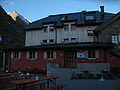
photos

Complex with winter house
Main entrance

With Taschachferner

Winter house

Taschachhütte around 1894

Floor plan of the Taschachhütte (1874) by Johann Stüdl


Literature / maps
- Alpine Club Card 30/6 Ötztal Alps, Wildspitze (1: 25,000)
- Alpine Club Card 30/2 Ötztal Alps, Weisskugel (1: 25,000)
- Glacier Report 2004/2005 of the Austrian Alpine Club (ÖAV)
Web links
- Taschachhaus in the historical alpine archive of the alpine clubs in Germany, Austria and South Tyrol (temporarily offline)
Individual evidence
- ^ History of Taschachhaus. In: taschachhaus.com. Retrieved August 3, 2020 .