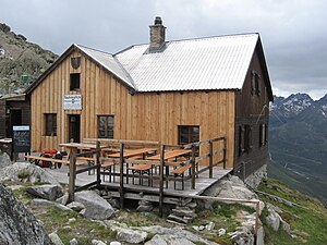
Rauhekopfhütte
| Rauhekopfhütte DAV hut category I |
||
|---|---|---|
| location | rear Kaunertal in the Weißkamm ; Landeck district , state of Tyrol , Austria ; Valley location: Municipality of Kaunertal , | |
| Mountain range | Ötztal Alps | |
| Geographical location: | 46 ° 52 '12 " N , 10 ° 45' 46" E | |
| Altitude | 2731 m above sea level A. | |
|
|
||
| owner | Frankfurt am Main section of the DAV | |
| Built | 1888 | |
| Construction type | hut | |
| Usual opening times | End of June to mid-September | |
| accommodation | 0 beds, 21 camps | |
| Winter room | 9 bearings | |
| Web link | Website of the Frankfurt am Main section | |
| Hut directory | ÖAV DAV | |
The Rauhekopfhütte is an Alpine Club hut belonging to the Frankfurt am Main section of the German Alpine Club . It is located in the rear Kaunertal in the Weißkamm in the Ötztal Alps .
History
The Rauhekopfhütte was built in 1888 and expanded in 1939 and 1977/1978.
getting there
- Arrival by train: to Landeck .
- Arrival by bus: bus stop at the Gepatschhaus.
- Arrival by car: Kaunertaler Gletscherstraße to Fernergries (toll road).
Ascent
- From the Gepatschhaus or from the Fernergries via Steig to the Gepatschferner . Crossing the glacier tongue and via a path to the hut. The walking time is two to three hours.
- From the Gepatschhaus or from the Fernergries via Steig to the glacier gate of the Gepatschferner. Then over the glacier tongue and over the path to the hut. The walking time is two to three hours.
- Over the Weißseespitze : From the parking lot of the Kaunertaler Gletscherbahnen over the west ridge to the summit of the Weißseespitze. From there down over the glacier to the hut. The walking time is three to four hours.
- From the Kaunertaler Gletscherbahnen parking lot to the Nöderjoch (glacier, slope) and over the ridge and glacier to the hut. The walking time is two to three hours.
Tour possibilities
- Weißseespitze , 3498 m , walking time: 3 hours.
- Hochvernagtspitze , 3539 m .
- Fluchtkogel , 3500 m , walking time: 3 hours.
- Front 3437 m , middle 3450 m , rear Hintereisspitze 3485 m .
- Hochvernaglwand , 3435 m .
- Pinnacle , 3381 m .
- Großer Rauher Kopf , 2990 m .
Transitions
- On the ascent to the Gepatschhaus , 2–3 hours.
- Over the Wannetjoch (3110 m) to the Taschachhaus , 4½ hours.
- Wroclaw Hut
- To the Vernagthütte via the Gepatschjoch (3241 m), 5 hours.
- Brandenburger Haus , 3 hours
- Weißkugelhütte
- Hochjoch hospice
literature
- Walter Klier : Alpine Club Guide Ötztal Alps . Bergverlag Rother , Munich 2006. ISBN 3-7633-1123-8
- Alpine Club Card 30/2 Ötztal Alps, Weißkugel . German Alpine Association, Munich 2003. ISBN 3-928777-39-4
Web links
- Rauhekopfhütte in the historical Alpine archive of the Alpine clubs in Germany, Austria and South Tyrol (temporarily offline)

