
Hochjoch hospice
| Hochjoch Hospice DAV hut category I |
||
|---|---|---|
 |
||
| location | rear Rofental, south below the Guslarspitze ; Imst District , State of Tyrol , Austria ; Valley location: Vent | |
| Mountain range | Ötztal Alps | |
| Geographical location: | 46 ° 49 ′ 31 ″ N , 10 ° 50 ′ 2 ″ E | |
| Altitude | 2412 m above sea level A. | |
|
||
| owner | Berlin section of the DAV | |
| Built | 1927 | |
| Construction type | hut | |
| Usual opening times | Late June to late September | |
| accommodation | 20 beds, 50 camps , 16 emergency camps | |
| Winter room | 16 bearings | |
| Web link | Hochjoch hospice | |
| Hut directory | ÖAV DAV | |

The Hochjoch-Hospiz (also Hochjochhospiz ) is an Alpine Club hut of the Berlin section of the German Alpine Club . It is located in the furthest Rofental on the southeast slope of the Guslar peaks in the Weißkamm of the Ötztal Alps at an altitude of 2412 m above sea level. A. and is the base for crossing the Hochjoch , for climbing the three Guslar peaks, as well as the intermediate station on the way to the Brandenburger Haus .
history
First hut
At the suggestion of Franz Senn , the original hut was built between 1869 and 1872 on the southeast slope of the Rofental at an altitude of 2,450 m . Since 1911 it has belonged to the then Mark Brandenburg section of the German and Austrian Alpine Club (DOeAV) . The house was built in the form of a crouched building with a sheet metal pent roof, which was widespread at the time, directly on the slope so that any avalanches could be diverted via the roof. The hut was looted during the First World War , the outer walls were also deformed due to the pressure on the slopes, and the roof was destroyed several times by avalanches, so that it could no longer be used.

New building
A new house was to be built elsewhere since the early 1920s. In 1927 the new Hochjoch hospice was opened on the opposite side of the Rofenache valley . The old building has not been maintained since then and fell into disrepair. From 2002 to 2004 the house was completely renovated and equipped with new building technology.
Hut rise

The ascent takes place from Vent on the marked long-distance hiking trail no. 902 (walking time: 2½ hours). First past the Rofenhöfen and the junction to the Vernagthütte . The path leads along the rocky slope and on a gentle slope up to the hut.
The ascent route was previously named after Waldemar Titzenthaler , the long-time chairman of the Berlin section of the Mark Brandenburg region of the German and Austrian Alpine Association , which has not accepted any Jewish mountaineers as members since it was founded in 1899. That is why the path was renamed Cyprian-Granbichler-Weg in 2003 as a symbol against anti-Semitism. Granbichler was Franz Senn's guide and companion . A plaque commemorating Titzentaler, behind which his urn was buried, is still on the way. A memorial for Cyprian Granbichler stands at the place where he died on the old, no longer used path on the right side of the Rofental valley. The monument can be seen from the valley station of the material cable car to the Vernagthütte on the other side of the valley, about 100 meters above the Rote Bach.

View of Rofen

Haflinger horses near Rofen with a view of the rear Rofental
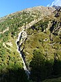
View to the Red Brook with a monument to Cyprian Granbichler (annotated)

Cyprian-Granbichler-Weg with Titzenthaler's grave

Cyprian-Granbichler-Weg: Bridge over the Vernagtbach


Transitions
- to Vernagthütte (altitude 2755 m )
- to the Brandenburg House via Delorette-Weg (altitude 3272 m )
- to the Weißkugelhütte (altitude 2544 m )
- to the restaurant Schöne Aussicht (altitude 2842 m )
- to the Similaunhütte (altitude 3019 m )
- to the Martin-Busch-Hütte (altitude 2501 m )
Tour possibilities
- Guslar peaks (3147 m) in approx. 2 hours
- Kesselwandspitze (3414 m) in approx. 4 hours
- Mutspitze in about 3 hours
- Weißkugel (3738 m) in approx. 6 hours
- Saykogel (3355 m) in approx. 4 hours
- Kreuzspitze (3455 m) in approx. 4 hours
- Fineilspitze (3514 m) in approx. 4 to 5 hours
- Fluchtkogel (3494 m) in approx. 4 to 5 hours
cards
- Alpine Club Card Sheet 30/2 Ötztal Alps - Weißkugel (1: 25,000)
Web links
- Flyer Hochjoch Hospice of the DAV section Berlin, 2016.
- 75 years Hochjoch-Hospiz , DAV Panorama, 2002, issue 4, pp. 42–46.
- Hochjoch-Hospiz in the historical Alpine archive of the Alpine associations in Germany, Austria and South Tyrol (temporarily offline)
Individual evidence
- ^ DAV section Berlin, leaflet on the Hochjochhospiz, Berlin 2007
- ↑ A board for dealing critically with history using the example of Rofental , alpenverein.at, accessed on April 16, 2020
- ↑ Alpine Club Maps of the Eastern Alps. Retrieved October 6, 2019 .