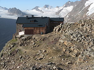
Ramolhaus
| Ramolhaus DAV hut category I. |
||
|---|---|---|
| location | rear Gurgler valley ; Tyrol , Austria | |
| Mountain range | Ötztal Alps | |
| Geographical location: | 46 ° 49 ′ 46 ″ N , 10 ° 58 ′ 10 ″ E | |
| Altitude | 3006 m above sea level A. | |
|
|
||
| owner | DAV - Hamburg and Niederelbe section | |
| Built | 1881-1883 | |
| Construction type | hut | |
| Usual opening times | End of June to around September 20th | |
| accommodation | 18 beds, 34 camps , 4 emergency camps | |
| Winter room | 10 bearings | |
| Web link | Ramolhaus | |
| Hut directory | ÖAV DAV | |
The Ramolhaus is an Alpine Club hut belonging to the Hamburg and Niederelbe section of the German Alpine Club . It is located on the southeast slope of the rear Gurgler Valley on a prominent rock head high above the melting tongue of the Gurgler Ferners in the main ridge in the Ötztal Alps .
The Ramolhaus was built from 1881 to 1883 and expanded in 1898, 1929 and 2005.
Hut rise
The ascent takes place from Obergurgl ( 1927 m ) on the marked long-distance hiking trail No. 902 in a walking time of four hours. In Obergurgl, the Gurgler Ache is first crossed in a south-westerly direction. The path first climbs up the western slope of the valley in two bends , then crosses a stream and continues with a moderate incline over Hochmäder (mowing meadows) of the Gurgl farmers up into the valley. After passing the Küppele-Alm at an altitude of approx. 2300 m , the path initially climbs steeply and crosses further streams under the rocky and craggy slopes of the Ramolkogel . Finally, it goes up over rubble slopes and in a right bend to the rock head on which the hut stands.
Transitions
- To the Langtalereckhütte (altitude 2430 m, walking time: 2 hours): The descent is first on the Hüttenweg towards Obergurgl . After a short time after the first big bend, the marked but not signposted path branches steeply down to the right and meets the path that leads from Obergurgl to the Piccard bridge , a suspension bridge that has been the old one since 2017 Way over the Gurgler Ferner replaced. After the well-secured climb on the other side, you reach the hut path to the Hochwildehaus, which you follow to the left down to the Langtalereckhütte.
- To the Hochwildehaus (altitude 2866 m, walking time: 1½ hours): On the way in the direction of the Langtalereckhütte to the ascent to the Hochwildehaus. There, however, up to the right on a good path to the hut, which is visible from afar.
- To Vent over the Ramoljoch (altitude 3186 m, walking time: 3½ hours): Behind the hut, first on a well-marked path over boulders, then a little downhill to the remains of the Ramolferner . On it to the northwest until you can see a quite long ladder on the left, over which the lowest climbing point can be easily overcome. With additional safety devices, the path follows an easy climb over rocks up to the Ramoljoch. On the other side, first down over steep firn or rubble on the right edge of the glacier and later on and next to the right moraine on the marked trail that leads over the slopes of the north-west falls of the Ramolkogel to the Ramolalm (altitude 2215 m) and further down to Vent .
- To the Martin-Busch-Hütte (altitude 2501 m, walking time: 5 hours) over the Ramoljoch (altitude 3186 m): As on the way to Vent, first over the Ramoljoch. At an altitude of approx. 2840 m, turn left onto the Diemweg , cross the Spiegelbach and around the Vorderen Spiegelkogel in a wide arc to the south, after crossing the Diembach westwards steeply down into the Niedertal and there first over the southern bank of the Niedertalbach into the valley . After crossing it steeply up through a ditch to the wide Hüttenweg, past the Schäferhütte to the Martin-Busch-Hütte.
Tour possibilities
- Ramolkogel (altitude: 3550 m); Walking time: 2½ to 3 hours
- Hinterer Spiegelkogel (altitude 3426 m); Walking time: 2–2½ hours
- Firmisanschneide (altitude 3491 m); Walking time: 2–3 hours
- Schalfkogel (altitude 3540 m); Walking time: 3 hours
cards
- Alpine Club Card Sheet 30/1 Ötztal Alps - Gurgl (1: 25,000)
literature
- Britta Wilken: 125 years of the DAV hut - Hamburg's highest house in Obergurgl in Ötztal . In: DAV Panorama . No. 6 , December 2006, ISSN 1437-5923 , p. 54–57 ( PDF , 602 kB).
Web links
- Hamburg and Lower Elbe Section
- Ramolhaus in the Historical Alpine Archive of the Alpine Clubs in Germany, Austria and South Tyrol (temporarily offline)

