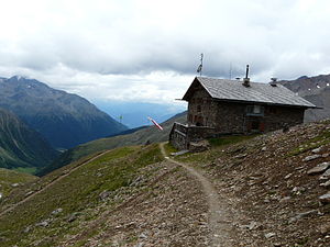
Oberetteshütte
| Oberetteshütte AVS hut category I |
||
|---|---|---|
|
Oberetteshütte from the northeast |
||
| location | Muddy valley ; South Tyrol , Italy | |
| Mountain range | Ötztal Alps | |
| Geographical location: | 46 ° 45 '53.3 " N , 10 ° 42' 40.3" E | |
| Altitude | 2670 m slm | |
|
|
||
| builder | Section Upper Venosta Valley (local group: Mals ) of the AVS | |
| owner | Section Upper Venosta Valley (local group: Mals ) of the AVS | |
| Construction type | hut | |
| Usual opening times | Late June to late September | |
| accommodation | 50 beds, 23 camps | |
| Winter room | 20 bearings | |
| Web link | Oberetteshütte | |
| Hut directory | ÖAV DAV | |
The Oberetteshütte is a refuge in the Matscher Valley in the South Tyrolean part of the Ötztal Alps .
Location and surroundings
The hut is located on the eastern side of the upper Matscher valley at an altitude of 2670 m . It is the starting point for the route to the eastern Schnalstal via the Bildstöckljoch and to the Schwemser Spitze , which can be reached after an ascent over the Oberettesferner and Oberettesjoch . In northern direction to get over the Holler-lip to the interior and exterior source tip , the white ball and the interior and exterior bears Bart Kogel .
history
A first refuge on the site of today's Oberetteshütte was built by the Prague section of the German and Austrian Alpine Club as the Carlsbader Hut and inaugurated in 1883. In 1902 it was renamed Höllerhütte after the Karlsbad city councilor Franz Höller, who had supported the building . After the First World War , the Italian state expropriated the refuge and handed it over to the Club Alpino Italiano . After the previous building burned down with the exception of a few remains of the wall in 1945, the Upper Venosta Valley (local group: Mals ) of the Alpine Association South Tyrol built today's hut in 1988, which owes its name to the nearby Oberettesferner.
Neighboring huts
- Hochjochhospiz ( 2413 m ), walking time 6 hours
- Weißkugelhütte (Rif.Pio XI) ( 2557 m ), walking time 8 hours
- Schöne-Aussicht-Hütte (Rif. Bella Vista) ( 2842 m ), walking time 6 hours
Mountain tours
- Weißkugel ( 3739 m ), walking time 4½ hours
- Outer spring peak ( 3385 m ), walking time 3 hours
- Schwemserspitze , also Oberettesspitze ( 3459 m ), walking time 4 hours
- Saldurspitze ( 3433 m ), walking time 3–4 hours
- Innerer Bärenbartkogel ( 3557 m ), walking time 4½ hours
- Outer Bärenbartkogel ( 3473 m ), walking time 4½ hours
- Freibrunnerspitze ( 3355 m ), walking time 20 minutes
- Lagaunspitze ( 3439 m ), walking time 4 hours
- Upper Saldurkopf ( 3429 m ), walking time 3½ hours
- Southern Schwemmserspitze ( 3296 m ), walking time 1½ hours
- Matscherjochsee, walking time 8 hours
- Saldurseen, walking time 6¾ hours
cards
- Alpine Club Card . Sheet 30/2: Ötztal Alps - Weißkugel (1: 25,000)
Web links
- Höllerhütte in the historical Alpine archive of the Alpine clubs in Germany, Austria and South Tyrol (temporarily offline)
- Oberetteshütte in the historical Alpine archive of the Alpine clubs in Germany, Austria and South Tyrol (temporarily offline)
Individual evidence
- ↑ Casa Editrice Tabacco : Topographical hiking map 1: 25,000, sheet 043, Vinschgauer Oberland
- ↑ Hans Kammerer: Refuge huts in South Tyrol . Tappeiner, Lana 2008, ISBN 978-88-7073-422-5 , pp. 18 .
- ^ Franz Mock: Oberetteshütte . In: AVS-Mitteilungen . March 2012, p. 26-27 .
- ↑ To the Weißkugel (3,739m) from the Oberetteshütte. Retrieved June 20, 2019 .
- ↑ To the lonely Saldurspitze 3.433m. Retrieved June 20, 2019 .
- ↑ From the Oberetteshütte to the southern Schwemmserspitze 3296m. Retrieved June 20, 2019 .
- ↑ Oberetteshütte - Matscherjoch - Oberetteshütte. Retrieved June 20, 2019 .
- ↑ To the Saldurseen. Retrieved June 20, 2019 .


