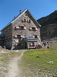
Big game house
| Hochwildehaus DAV hut category I |
||
|---|---|---|
| location | Eastern edge of the Gurgler Ferners ; State of Tyrol , Austria ; Valley location: Sölden (Ötztal) , district Obergurgl | |
| Mountain range | Ötztal Alps | |
| Geographical location: | 46 ° 48 '17 " N , 10 ° 59' 17" E | |
| Altitude | 2883 m above sea level A. | |
|
|
||
| owner | DAV - Karlsruhe section | |
| Built | Original construction in 1896, extension in 1939 | |
| Construction type | hut | |
| Usual opening times | Beginning of July to mid-September | |
| accommodation | 30 beds, 60 camps , 10 emergency camps | |
| Winter room | 14 bearings | |
| Web link | Website of the section | |
| Hut directory | ÖAV DAV | |
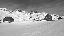
The Hochwildehaus is an Alpine Club hut belonging to the Karlsruhe section of the German Alpine Club . It is located on the eastern edge of the Gurgler Ferners at the stone table on the Schwärzenkamm next to the old Fidelita hut in the Ötztal Alps . It has been closed for an indefinite period since 2016.
history
The Hochwildehaus was built in 1938/39. It was built next to the unmanaged Fidelita hut built in 1896. The latter now serves the Hochwildehaus as a winter room and self-catering hut for 12 people. From 2011, increasing structural damage was documented at the Hochwildehaus. The reason is the thawing of the permafrost ground on which the house was founded, caused by global warming . A supporting structure erected in 2014 temporarily secured it. In 2016 it was closed for security reasons. A new replacement building is being planned.
Hut rise
The ascent is from Obergurgl ( 1927 m , walking time to the hut: 5 hours) first to the Langtalereckhütte ( 2430 m ). Behind the hut, the path first leads briefly down into the Langtal, over a good bridge and on the other side very steeply westwards, up the rocky ridge of the Schwärzenkamm and onto the moraine of Gurgler Ferners . Past the junction towards Obergurgl and past a small lake, finally a little steeper up to the hut.
Transitions
- To the Langtalereckhütte (altitude 2430 m ): back on the ascent of the hut.
- To the Ramolhaus (altitude 3006 m ): First back on the Hüttenweg and past a small lake. After that, marked climbing tracks down to Gurgler Ferner can be seen on the left . Once at the bottom, there is a generally uncritical glacier crossing in the lower flat zone of the glacier. The way down to and across the glacier is no longer signposted separately, as the crossing from the glacier to the opposite side has recently become critical. In July 2007 only a small glacier bridge was left. On the left side, the path initially leads only moderately steeply towards the north, later it branches off quite steeply to the left and meets the ascent of Obergurgl . On this in an arc to the hut, which has been visible for a long time.
- To the Eishof .
- To the Martin Busch Hut .
- To the Stettiner Hütte (altitude 2895 m ) via Nördliche Hochwilde ( 3461 m ) in 6 hours.
Tour possibilities
- Hochwilde (north summit 3461 m , south summit 3482 m ; 4 hours)
- Annakogel (altitude 3336 m ; 2 hours)
- Schwarzenkamm (altitude 2980 m ; 1 hour)
- Bankkogel (altitude 3309 m ; 3 hours)
- Falschunggspitze (altitude 3363 m ; 3½ hours)
- Karlesspitze (altitude 3465 m ; 4½ hours): Over the Querkogeljoch
- Querkogel (altitude 3448 m ; 4 hours): Over the Kleinleitenjoch
- Schalfkogel (altitude 3540 m ; 4 hours): From the Schalfkogeljoch over the south ridge
- Firmisanschneide (altitude 3491 m )
cards
- Alpine Club Card Sheet 30/1 Ötztal Alps - Gurgl (1: 25,000)
literature
- Walter Klier : AVF Ötztaler Alpen , Bergverlag Rother , Ottobrunn, ISBN 3-7633-1123-8
Web links
- Karlsruhe section in the DAV
- Hochwildehaus in the historical alpine archive of the alpine clubs in Germany, Austria and South Tyrol (temporarily offline)
- Fidelitashütte in the historical Alpine archive of the Alpine clubs in Germany, Austria and South Tyrol (temporarily offline)
Individual evidence
- ^ Alpenverein-Karlsruhe.de: Hochwildehaus
- ^ "Karlsruhe's tallest building" collapses. In: Press review Karlsruher Alpenverein. September 3, 2014, archived from the original on February 10, 2019 ; accessed on February 10, 2019 .


