Schalfkogel
| Schalfkogel | ||
|---|---|---|
|
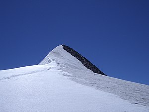
Schalfkogel from the north, from Firmisanjoch |
||
| height | 3537 m above sea level A. | |
| location | Tyrol , Austria | |
| Mountains | Ötztal Alps | |
| Dominance | 4.4 km → Back blackness | |
| Notch height | 348 m ↓ Ramoljoch | |
| Coordinates | 46 ° 48 '6 " N , 10 ° 57' 32" E | |
|
|
||
| First ascent | 1830 by Frédéric Mercey | |
| Normal way | over the south ridge from the Hochwildehaus as an alpine tour | |
|
North ridge |
||
The Schalfkogel is 3537 m above sea level. A. high mountain in the Ramolkamm , a northward branch of the main ridge in the Ötztal Alps , in the Austrian state of Tyrol . Seen from the east, the mountain shows a steep firn and rock flank above the Gurgler Ferner , to the north a firn ridge extends , which forms a steep firn divide in the upper area. From the west you can see the summit as a flat, even pyramid. The mountain was first climbed in 1830 by the French travel writer Frédéric Mercey, a few porters from the Pfelder Valley and a mountain guide from Meran, whose name has not been passed down.
Location and surroundings
The Schalfkogel is about seven kilometers as the crow flies south-southwest of Obergurgl , a district of the municipality of Sölden . The mountain is completely surrounded by glaciers . In the north-west lies the Diemferner , in the north-east the Gurgler Ferner and the Kleinleitenferner and in the south the Nördliche Schalfferner , which was previously connected to the Schalfferner . Adjacent peaks are in the west, separated by the Diemjoch ( 3315 m ) and the 3398 m high Hintere Diemkogel . In the course of Nordgrats , is separated by the 3287 meter high Firmisanjoch that Firmisanschneide with 3490 m height. In the south, separated by the Schalfkogeljoch ( 3373 m ), lies the 3446 m high Kleinleitenspitze .
Bases and routes
The route of the first climbers in 1830 led from the Pfelderer Tal up to the Hochwildejoch (at 3225 m above sea level) and over the Schwärzenkamm to the Stone Table , where the Hochwildehaus stands today. In 1830 there was already a stone shed there, in which Mercey and his companions stopped and then crossed west to the Schalfkogel. It turned out that the strong sunlight on the glacier caused serious eye problems for some of the members of society. After a short stay at the summit, you descended to Katharinaberg in Schnalstal .
For a celebration of Schalfkogels over the normal route , the leichtesten increase that of Obergurgl achievable serves Hochwildehaus on 2883 m height as the starting point. The path leads from the hut as an alpine tour with appropriate equipment and glacier experience, initially in a westerly direction along the 2800 meter contour line over the Gurgler Ferner. From the Schalfkogeljoch you can reach the summit via the rocky south ridge in, according to literature, a total of four hours of walking from the Hochwildehaus. It is also possible to climb from the Ramolhaus ( 3005 m ) to the north . The ascent from the north takes three hours via the Firmisanjoch and the north ridge .
Literature and map
- Walter Klier : Alpine Club Guide Ötztaler Alpen , Bergverlag Rudolf Rother , Munich 2006, ISBN 3-7633-1123-8
- Richard Goedeke : 3000er in the Northern Alps , Bruckmann, Munich 2004, ISBN 3-7654-3930-4
- Alpine Club map, scale 1: 25,000, sheet 30/1, Gurgl , ISBN 3-928777-38-6
Web links
Individual evidence
- ↑ Clem Clements, Jonathan de Ferranti, Eberhard Jurgalski , Mark Trengove: The 3000 m SUMMITS of AUSTRIA - 242 peaks with at least 150 m of prominence , October 2011, p. 10.
- ↑ Federal Office for Metrology and Surveying Austria: Schalfkogel on the Austrian Map online (Austrian map 1: 50,000) .
- ^ Frédéric Mercey: Le Tyrol et le Nord de l'Italie , Arthur Bertrand, Paris 1833
- ^ Walter Klier: Alpine Club Guide Ötztal Alps , Munich 2006, p. 376 f.


