Ramolkamm
| Ramolkamm | |
|---|---|
|
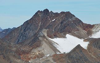
Großer Ramolkogel from the southeast ( Hochwilde ) |
|
| Highest peak | Great Ramolkogel ( 3549 m ) |
| location | Tyrol ( Austria ) |
| part of | Ötztal Alps |
| Coordinates | 46 ° 51 ' N , 10 ° 57' E |
The Ramolkamm is a mountain ridge running in north-south direction in the Ötztal Alps between the Venter Valley in the west and the Gurgler Valley in the east. At the Karlesspitze it branches off to the north from the Schnalskamm , part of the main Alpine ridge , and ends at Zwieselstein , where the two valleys unite. The highest point of the ridge is the eponymous Große Ramolkogel , the northern end point is the Mittagskogel ( 2825 m above sea level ), a pre-summit of the Nederkogel .
Important peaks
Some important peaks of the Ramolkamm are (from north to south):
| summit | Height (meters) |
|---|---|
| Nederkogel | 3163 m above sea level A. |
| Stockkogel | 3109 m above sea level A. |
| Zirmkogel | 3278 m above sea level A. |
| Gampleskogel | 3399 m above sea level A. |
| Ramolkogel | 3549 m above sea level A. |
| Spiegelkogel | 3426 m above sea level A. |
| Company cutting edge | 3490 m above sea level A. |
| Schalfkogel | 3537 m above sea level A. |
| Karlesspitze | 3463 m above sea level A. |
literature
- Walter Klier : Alpine Club Guide Ötztaler Alpen , Bergverlag Rudolf Rother , Munich 2006. ISBN 3-7633-1123-8
